


Introduction
Nessana is located in the south-western Negev desert, on the modern border between Israel and Egypt (Figure 1). The site consists of a mound (the acropolis) and a lower city separated by a stream bed of the Nahal Ezuz (Figure 2). Initially established in the Hellenistic period (c. fourth–third centuries BC) and housing a garrison in the late Roman period (from fourth century AD), Nessana reached its zenith serving as a principal hub for Christian pilgrims travelling from the Holy Land to Mount Sinai (Külzer Reference Külzer, Daim, Pahlitzsch, Patrich, Rapp and Seligman2020) in the Byzantine and early Islamic periods (sixth–seventh centuries CE). The acropolis includes a late Roman–Byzantine fort with a monumental staircase down the hill to the lower town, on the eastern bank of Nahal Ezuz.

Figure 1. Location of Nessana (figure by M. Frumin).

Figure 2. Aerial view of ancient Nessana showing excavation areas (photograph by Y. Shmidov & A. Wiegmann).
The important role of pilgrimage in the life of the settlement is clearly reflected in the large number of church buildings at the site, the inscriptions and graffiti in various languages—Greek, Arabic, Aramaic, Armenian and Georgian—and the testimony of the Nessana papyri, discovered in the 1930s (Casson & Hettich Reference Casson and Hettich1950; Kraemer Reference Kraemer1958; Hoyland Reference Hoyland2021). Apparently, Byzantine Nessana became an essential stopping point for pilgrims entering the Sinai desert; a place where caravans were formed and where guides and other essential services were supplied. This role was maintained during the early Islamic period. Abandoned sometime during the Abbasid period, the site was inhabited again only on the eve of the First World War when the Ottoman authorities decided to turn it into their regional administrative and military centre. This new settlement, known as ‘Auja al-Hafir, was built on top of the ancient remains and badly damaged the archaeology.
The Nessana archaeological project
Previous archaeological excavations, conducted during two expeditions, have exposed churches and private dwellings (Colt Reference Colt1962; Urman Reference Urman2004), and the cemeteries have recently been the focus of another study (Betzer Reference Betzer2021). Rubbish mounds of the site were also excavated within the framework of a wide-scope project on the Byzantine–Islamic transition in the Negev (Tepper et al. Reference Tepper, Weissbrod, Erickson-Gini and Bar-Oz2020).
The solid work produced by excavations in the Negev, in general, over the preceding decades (e.g. Bar-Oz et al. Reference Bar-Oz, Weissbrod, Erickson-Gini and Boaretto2019; Avni Reference Avni, Mizzi, Rassalle and Grey2023) provides a base for the renewed investigation of Nessana. The Nessana Archaeological Project was launched in 2022, on behalf of Ben-Gurion University, with the aim of exposing the material remains of religious structures and pilgrim facilities at the site and revealing the ground plan of the ancient settlement.
Synchronised investigations and renewed excavation at the site were initiated in 2022 and involved extensive efforts to gather and examine available historic sources and field documentation and materials from prior archaeological work. New and existing data were thus compiled and collated to ascertain the overall plan of the site and the spatial outline of its main arteries and public spaces, which had so far remained archaeologically obscure.
Revealing ancient Nessana
Attempts to use ground penetrating radar and other geomagnetic-research techniques in the area were unsuccessful due to the saturation of the soil with modern metal—iron reinforcements, shells, canisters, tin cans, etc. It was, however, possible to combine GIS modelling of the ancient remains with surface survey, carried out by the project team, to reconstruct primary plans of the urbanised village—the most detailed plan of the site produced in 100 years of research at Nessana (Figure 3). In contrast to other large Byzantine villages of the Negev with their ‘organic growth’ schemes, Nessana seems to present a pre-planned layout, with main street arteria dividing the lower settlement into small quarters and churches located along these central streets.

Figure 3. Survey map of ancient Nessana with main street arteria highlighted in red (drafting by Y. Shmidov).
Two large churches and a small monastery were found at the acropolis, two more churches are known down the hill; all appear to have functioned simultaneously during the Byzantine and early Islamic periods. The churches were the only public structures of Nessana to have been previously exposed; all were ornately decorated basilicas, belonging to the most common architectural form of early ecclesiastical edifices in the Holy Land. The unusual number of churches at the site is probably related to the economic wealth of Nessana, its role in the pilgrimage movement and investments made by the local elite (see Ruffini Reference Ruffini2011: 207–8).
Observed during preliminary surveys for the project, and partly exposed in a salvage excavation by the Israel Antiquities Authority in 2022, the remains of yet another chapel were excavated in our first excavation season. The chapel was part of an impressive architectural complex with a chapel, bathhouse, mosaic-decorated courtyard, paved rooms and various water installations; all interpreted as parts of a pilgrim hospice, located on the southern periphery of the site—the first of its kind discovered at Nessana (Figure 4). The complex functioned during the Byzantine and early Islamic periods, and its final abandonment phase is marked by an informal Kufic inscription from the late seventh–early eighth century AD.

Figure 4. A pilgrimage hostel complex partly exposed during the 2023 excavations (photograph by Y. Shmidov & A. Wiegmann).
Owing to the arid desert climate, Nessana is exceptional in the high preservation of organic materials such as textiles, leather, baskets and botanical remains. Even in the first season of the renewed excavations, numerous botanical remains were collected, together with textile and leather fragments, and wooden beams (Figure 5).

Figure 5. Finds from collapse layers of the pilgrimage hostel: a) fragment of a carved bone; b) Greek dipinto on fragments of a locally produced jar; c) wooden beams; d) ostrich eggshell (photographs by Y. Ivanovsky & A. Peretz).
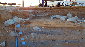
The first two fieldwork seasons have facilitated the formulation of the stratigraphic sequence for the site, determination of the thickness of the archaeological layers and identification of the ceramic repertoire. Of special interest are the processes of the decline and final abandonment of the architectural complexes, which began during the Byzantine-Islamic transition (Figure 6).

Figure 6. Excavation profile showing the deposition of decline and abandonment layers, Area CC, view to east (photograph courtesy of the Nessana Expedition).
We expect that the future exploration of Nessana, undertaken in conjunction with the study of data from previous excavations, will provide a more coherent picture of life in the small late antique settlement on the desert fringe and will shed light on the material culture of ancient pilgrimage to the Holy Land.
Acknowledgements
The author would like to thank the members of the excavation team, students and volunteers for their devoted work, and our colleagues for their generous help and consultations.
Funding statement
The ongoing project receives generous financial support from Gerda Henckel Stiftung (Grants AZ 56/V/22 and AZ 29/F/23) and the Archaeology Department of the Ben Gurion University of the Negev.


 Open access