Introduction
For over a century, the earliest Viking activity in Britain and Ireland (the `Insular area` referred to in this paper) has been the topic of intense scholarly discussion. The written and archaeological evidence have been regularly reviewed, most recently by Emer Purell (Reference Purcell, Clarke and Johnson2015) and Clare Downham (Reference Downham2017) who have studied the first generation of Vikings in Ireland and the written sources for the earliest Viking activity in England, respectively.
The purpose of this article is to consider the Norwegian evidence in light of the current discussions into initial direct contact across the North Sea. First, it reviews the chronology and geographical distribution of 16 early burials containing Insular metalwork, including new finds and data which have not been included in previous debates about the earliest Viking activity. Second, the article examines the nature of the initial phase of contact with a focus on maritime mobility and environmental knowledge, which must have been vital aspects but remain under-investigated components of the initial phase of contact. Finally, the article brings together these elements and proposes a model of movement and maritime communication for the earliest voyages across the North Sea.
The Earliest Recorded Raids and The Beginning of the Viking Age
Over the years, many scholars have expressed different views about when the earliest direct contact between Norway and the Insular world took place and the nature of this interaction. The relationship between the archaeological evidence and information recorded in the Irish annals and the Anglo-Saxon Chronicle has been central to these discussions.
The first written record of a Viking attack on Insular land took place in Portland, Dorset, in ad 789—or sometime during the reign of King Beorthric of Wessex between ad 786 and 802 if we base the dating on a cautious use of the sources (Dumville, Reference Dumville, Brink and Price2008: 356). According to the Anglo-Saxon Chronicle, three ships of Northmen arrived near a royal residence, where they killed the king's reeve who rode out to meet them. While the earliest source refers to the Northmen as ‘Dani’ (a general term for Scandinavians), later versions of the Chronicle (Versions D, E, and F) identify the ships as originating from Hordaland in the western part of present-day Norway (Dumville, Reference Dumville, Brink and Price2008: 356, Downham, Reference Downham2017: 1). Possibly after the altercation in Portland, the earliest Viking raid on an ecclesiastical location is the well-known attack on the monastery on Lindisfarne in north-eastern England in June 793, recorded in the Northern recension of the Anglo-Saxon Chronicle, versions D and E (Downham, Reference Downham2017: 2).
In the following decade, the Insular sources record repeated raids around the shores of Britain and Ireland. This includes the sacking of the monastery at the ‘mouth of the River Don’ (possible Jarrow, or a monastery in South Yorkshire) and raids throughout the Hebrides in ad 794, on the islands of Iona, Inishmurray, Inishbofin, and Rechru (probably Lambay Island, Co. Dublin) in ad 795, while mainland Scotland (Argyll) and Ireland were targeted from ad 796 onwards (Dumville, Reference Dumville, Brink and Price2008; Downham, Reference Downham2000). While the annals and Chronicle show an emphasis on early raids on Ireland and northern Britain, other written sources including letters, foreign chronicles, and charters, suggest that large parts of southern England were also targeted by ‘pagans’ around the same time. These accounts are however somewhat supressed in the Chronicle, which mainly records the Vikings as a regular threat to southern England from c. ad 830 and onwards. It appears that the Anglo-Saxon Chronicle is somewhat biased towards King Alfred and his family by playing down the impact of the Vikings before the reign of King Ecgberht, King Alfred's grandfather (Downham, Reference Downham2017: 12).
Since the early twentieth century, the earliest recorded raids have generally been regarded as the starting point of contact across the North Sea. By tradition, this has led to the widespread notion that any Insular metalwork could only have reached Scandinavia after these events. This principle is often referred to as the ‘Shetelig axiom’ and has been both influential and much debated. While early researchers were also open to the idea of direct pre-Viking contact, this topic became the subject of lively scholarly discussion in the 1990s. Instead of viewing the Lindisfarne attack as the first time the ‘Norwegian’ Vikings entered the Insular world, it was strongly argued that a pre-Viking phase of migration and trade to Atlantic Scotland took place from the early to mid-eighth century or even earlier (e.g. Myhre, Reference Myhre, Faulkes and Perkins1993, Reference Myhre, Clarke, Ní Mhaonaigh and Floinn1998, Reference Myhre2000; Weber, Reference Weber, Ambrosiani and Clarke1994, Reference Weber, Kroger and Naley1996; Solli, Reference Solli1996). This view is sometimes referred to as the ‘Myhre’ model because of Bjørn Myhre's influential role in these discussions. As summarized elsewhere (see Barrett, Reference Barrett, Brink and Price2008: 418–21), the debate principally centred around four aspects of the archaeological evidence: 1) Viking graves with early types of brooches or weapons in Scotland; 2) early combs from Orkney made of Scandinavian reindeer antler; 3) pollen analysis on Faroe indicating a pre-Viking presence; and 4) early Insular objects in Norwegian graves. The first of these pieces of evidence has since been largely dismissed because the early brooches show clear signs of wear and repair and because of the difficulties of dating Scottish graves on the basis of Norwegian typologies (e.g. Morris, Reference Morris, Clarke, Ní Mhaonaigh and Floinn1998: 88; Owen, Reference Owen, Adams and Holman2004). The presence of Scandinavian reindeer antler from Orkney has also been reviewed and has shown that the arrival of this material cannot be securely dated to before the early ninth century (Ashby, Reference Ashby2009; von Holstein et al., Reference Von Holstein, Ashby, van Doorn, Sachs, Buckley and Meiri2014). The evidence for a pre-Viking Age presence on the Faroes has recently been confirmed by new pollen evidence and dates. These results are interpreted as ‘firm evidence for the human colonisation of the Faroes by people of unknown geographical and ethnic origin some 300–500 years before the large-scale Viking colonisation of the ninth century’ (Church et al., Reference Church, Arge, Ascough, Bond, Cook and Dockrill2013: 231–32). While not forming part of the original discussion, an early date from a site in Norwick, Shetland, obtained in 2003, has also been used to suggest Norse settlement before ad 793 (Ballin Smith, Reference Ballin Smith, Smith, Taylor and Williams2007). However, the date was obtained from carbonized food deposits and could easily be a result of marine reservoir effects on cooked fish, or even statistical chance, since the remaining dates from the site largely suggest a later settlement date (Barrett, Reference Barrett, Anderson, Barrett and Boyle2010: 291). At present, there is little archaeological evidence to support the hypothesis of a Norse settlement in the Scottish Isles before the mid-ninth century (see Barrett, Reference Barrett, Brink and Price2008, Reference Barrett, Anderson, Barrett and Boyle2010).
As shown above, much of the Insular evidence of possible pre-Viking contact has been thoroughly reviewed, and in some cases dismissed, in the last two decades. In the following section, I shall focus on the fourth, and perhaps least studied, element of evidence for early Scandinavian activity in the west: Insular metalwork found in early burials in Norway.
The Earliest Insular Metalwork: Composition
Over forty years ago, Egil Bakka discussed the chronology of a group of eleven early graves from Norway with Insular metalwork, all of which also contained brooches of the late Vendel/Merovingian periods or transitional types that survived into the Early Viking Age (Bakka, Reference Bakka1973; see also Wamers, Reference Wamers, Clarke, Ní Mhaonaigh and Floinn1998: 51–54). To this group, five further finds, from Ytre Kvarøy, Skei, Geite, Myklebost, and Farmen, can be added (Figure 1 and Table 1).
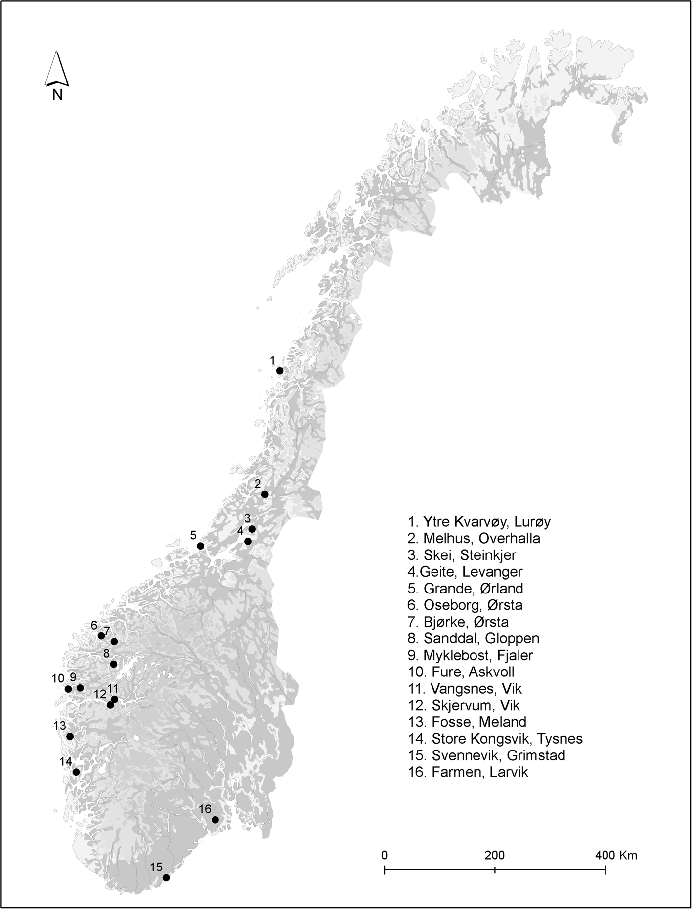
Figure 1. Distribution of the earliest Insular finds found in Norway.
Table 1. Overview of the early burials containing Insular material.
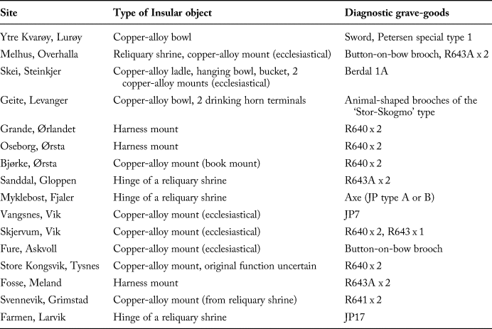
As shown in Table 1, the Insular metalwork comprises twenty-three objects from sixteen graves representing fourteen female and two male burials. The most significant piece is the complete reliquary from a woman's burial in Melhus (see Figure 6), one of only twelve largely complete Insular house-shaped shrines to have survived in Europe. The grave contained a further Insular find in the form of a reworked ecclesiastical mount, which was probably used as a brooch to fasten the deceased's fur cloak (see Heen-Pettersen & Murray, Reference Heen-Pettersen and Murray2018 for a recent presentation of this find). Such decorative and gilded copper-alloy mounts are by far the most common object type in the early Insular material, with fifteen pieces known from fourteen locations. Three of these, from Oseborg (Møre and Romsdal county) (Figure 2), Grande, and Fosse are harness mounts, all of which were reworked into dress accessories (Wamers, Reference Wamers1985: 93–96). While the metalwork from Store Kongsvik cannot be ascribed to an identified parent object, the remaining examples were probably once mounted on ecclesiastical objects. This includes an Anglo-Saxon book mount from Bjørke (Figure 2) that served as a pendant suspended from a bead-necklace worn by the deceased (Wamers, Reference Wamers1985: 95).
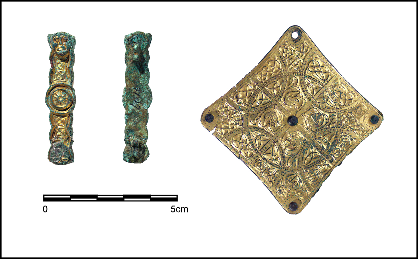
Figure 2. Left: back and front of harness-mount from Oseborg, Ørsta. Right: Anglo-Saxon book mount from Bjørke, Ørsta.
The metalwork from Sanddal, Farmen, and Myklebust is identified as hinges from reliquary shrines (Wamers, Reference Wamers1985: 19, 95; Aannestad, Reference Aannestad2015: 80). Further pieces from either reliquary shrines or other reliquaries are represented by the mounts from Skjervum, Melhus, Skei, and Svennevik. On five of these pieces, secondary perforations, sometimes associated with the remains of pin fittings and/or textiles, suggest that these were adapted for use as brooches (see Stenvik, Reference Stenvik2001: 33; Aannestad, Reference Aannestad2015: 307). The remaining ecclesiastical pieces belong to a group of mounts which may originally have been altar or tabernacle decorations, or decorations on processional crosses. This includes the hemispherical and flanged boss from Vangsnes and the metalwork from Fure (Figure 3). The latter belongs to a group of hollow, cast mounts in the shape of a truncated pyramid, similar to the mounts decorating the ‘Antrim Cross’. These two pieces were also reworked and probably worn as dress ornaments (Wamers, Reference Wamers1985: 96).
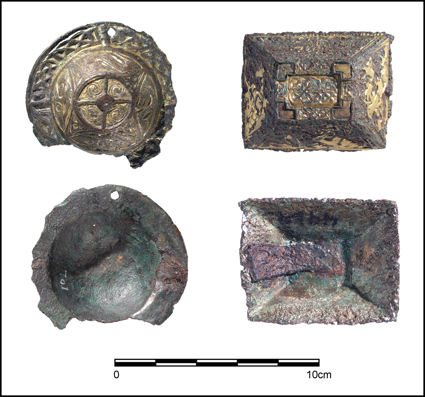
Figure 3. Left: the flanged boss from Vangsnes, Vik. Right: the mount from Fure, Askvoll.
Finally, the Insular finds from Ytre Kvarøy, Geite, and Skei were various items used for serving food and drink. The only hanging-bowl from this corpus comes from Skei, where it formed part of a fine set of serving equipment, together with a large bronze ladle and a small, bronze-bound bucket (Stenvik, Reference Stenvik2001). The large Insular bowls from Ytre Kvarøy (see Figure 7) and Geite belong to a group of copper-alloy vessels, which can be isolated from the hanging-bowl series since they lack suspension devices. The Geite grave also included two drinking horn terminals of Insular origin.
Chronological Difficulties
The material from the earliest burials, which provides the best indication of deposition dates, consists of decorated dress ornaments and weapon types, since other plain and undiagnostic finds are more difficult to place within a narrower time frame (see e.g. Bakka, Reference Bakka1973; Stenvik, Reference Stenvik2001; Heen-Pettersen & Murray, Reference Heen-Pettersen and Murray2018 for details about these further grave goods). As for beads, the work of Callmer (Reference Callmer1977) still forms the main typology for the Norwegian material. However, in our case, the problem with using his classification is the fact that Callmer explicitly used the ‘Shetelig Axiom’ when building his chronology and, therefore, presumed a post-Lindisfarne date for beads found with early Insular material (see e.g. Callmer, Reference Callmer1977: 77). Likewise, when Bakka discussed the early graves with Insular metalwork in 1973, he had to deal with the ‘problem’ of early styles of ornamented brooches in burials with imports. His solution was to propose that the styles continued in use until around ad 800 and that the deposition of Insular metalwork, therefore, largely corresponded with the ‘Shetelig Axiom’ (Bakka, Reference Bakka1973: 16-17). Since then, a number of researchers have studied and suggested various chronologies for the brooches of late Vendel-period Scandinavia, including transitional types surviving into the early Viking Age (e.g. Shetelig, Reference Shetelig and Nordman1927; Ørsnes, Reference Ørsnes1966; Jansson, Reference Jansson1985; Myhre, Reference Myhre, Faulkes and Perkins1993; Klæsøe, Reference Klæsøe1999; Rundkvist, Reference Rundkvist2010). The difficulties within a fine chronology have yet to be resolved, especially since these brooches were in use in the decades before and after the first recorded overseas raids.
Five of the graves in this study contained pairs of thin-shelled brooches of R640/JP 4 type (Figure 4). While older research grouped these brooches collectively under the type name R640, it is now generally agreed that they can be divided into two main types: The Small Plain type and the Large Plain brooches. All our examples belong to the latter group, with a suggested deposition date of c. ad 770–840 (see Rundkvist, Reference Rundkvist2010: table 10). A further four burials contained pairs of type R643 brooches. This group is also believed to date to the late eighth and early ninth century (see Rundkvist, Reference Rundkvist2010: 135). A similar date is suggested for the animal-shaped brooches of the rare ‘Stor-Skogmo’ type found in the richly-furnished cremation burial from Geite, which has recently been confirmed by radiocarbon dates (see below).
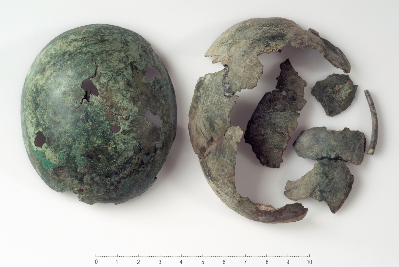
Figure 4. Oval brooches of R640 type from Bjørke, Ørsta.
Two further pairs of oval brooches from Vangsnes and Farmen (types JP7 and JP17) are classed as ‘transition types’ (TT) (Rundkvist, Reference Rundkvist2010: finds catalogue). Petersen (Reference Petersen1928) certainly suggested a slightly later manufacturing sequence for the Norwegian TT examples compared with the simple, thin-shelled R640 and R643 brooches. While he regarded JP7 as an early type going back to the end of the eighth century, JP17 was defined by Petersen as one of the earliest Viking-age types based on the ‘gripping beast’ motif. Rundqvist has however suggested a bipartition of this decoration, where the beasts used on the earliest types (such as JP17) may pre-date the Lindisfarne raid by a few decades (Rundkvist, Reference Rundkvist2010: 159–60).
A late eighth-century production date is also argued for the late types of button-on-bow brooches from Melhus and Fure (Gjessing, Reference Gjessing1934; Glørstad & Røstad, Reference Glørstad, Røstad, Vedeler and Røstad2015: 186–88). Finally, while representing a slightly later find, an early date is also indicated by the find of a Berdal type 1a brooch with a gripping beast ornament from Skei. It has been suggested that production of this brooch type began during the mid-eighth century, based on the finds of moulds in Ribe, Jutland (Myhre, Reference Myhre, Faulkes and Perkins1993: 186). There has, however, been considerable debate regarding the chronology of the layers associated with these finds. Feveile and Jensen (Reference Feveile and Jensen2000: 17–18) have reassessed the dating evidence and argued that the date of the earliest occurrence of Berdal brooches in Ribe must be adjusted to c. ad 780–790.
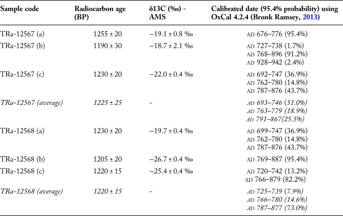
None of the above burials has previously been dated by radiocarbon analysis. In connection with this study, two samples were obtained from cremated animal bones from the base of the Insular bowl in the Geite burial. Since no collagen was preserved, the results were obtained by measuring the carbonate fraction in cremated bones (bio apatite). Each of the two samples was tested three times (see Table 2 and Figure 5) and the best estimates for the age are the average of the three measurements (at 95.4% probability): cal ad 693–867 (Tra-12567) and cal ad 725–877 (Tra-12568). However, a closer look at the individual results indicate a narrower timeframe. Only one measurement gave an early date of cal ad 676–776 (95.4% probability), while three samples provided very similar results of cal ad 768–896 (91.2% probability), ad 769–887 (95.4% probability) and cal ad 766–879 (82.2% probability). A deposition date of sometime after ad 766 therefore seems most likely, but the results also underline the methodological difficulties in obtaining the necessarily chronological resolution to confidently date burials to before or after the first recorded raids.
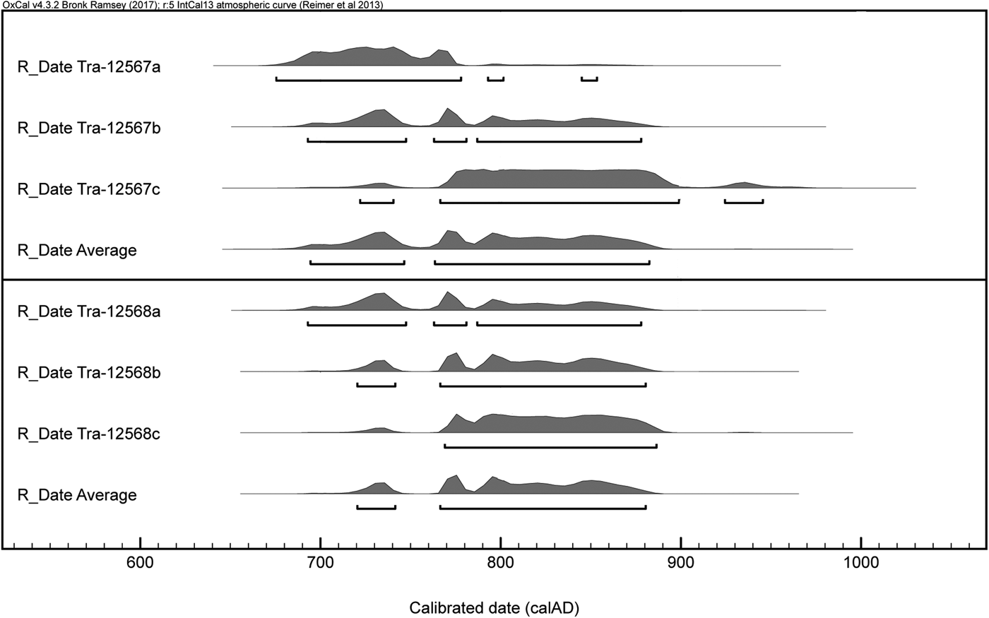
Figure 5. Geite, Levanger: calibrated dates using OxCal 4.2.4 (Bronk Ramsey, Reference Bronk Ramsey2013; Reimer et al., Reference Reimer, Bard, Bayliss, Warren Beck, Blackwell and Bronk Ramsey2013).
Table 2. Geite, Levanger: calibrated dates.
While this group of finds represents the earliest evidence of direct contact across the North Sea, it is also clear that both the typological and radiocarbon dates are coarse and offer us room to interpret the finds as either supporting or speaking against the ‘Shetelig axiom’. Since it is difficult to achieve fine-grained dating, the methodological and theoretical framework against which the imports can be interpreted becomes essential. This is especially true for interaction models, which have implications for the chronology and characterisation of the earliest Norse activity in Britain and Ireland.
Models of Movement
Today, there is general agreement that some form of pre-Lindisfarne contact must have existed (e.g. Barrett, Reference Barrett, Anderson, Barrett and Boyle2010: 297), but there have been few attempts to suggest new models of how this interaction took place since the discussions led by Myhre. Since the 1990s, the evidence to support a pre-Viking period of well-established connections has been significantly weakened, especially by Ashby's (Reference Ashby2009) dismissal of the reindeer comb evidence which was used as one of the principal pieces of evidence in these models. The main problem is still the lack of archaeological evidence for such early activity on either side of the North Sea. Admittedly, John Hines has argued convincingly for a phase of small-scale immigration from western Norway to south-eastern England in the fifth and sixth centuries, based on parallel stylistic elements found on square-headed brooches and other types of dress jewellery in these two areas (Hines, Reference Hines and Carver1992, Reference Hines, Kroger and Naley1996). This contact does, however, not seem to have continued into the following centuries (Hines, Reference Hines, Kroger and Naley1996: 27). Moreover, the small amount of western glassware in early eighth-century Scandinavian contexts are generally believed to have reached Scandinavia through the continental route (Myhre, Reference Myhre, Faulkes and Perkins1993: 189 and citations therein).
While there are indications that the continental route to southern England may have been known, I follow Ashby (Reference Ashby2009: 27) in believing that ‘we still lack the smoking gun’ of early contact between Norway and the Insular world of northern Britain and Ireland. This calls for a revision or certainly a modification in the characterisation of the earliest, direct Norse activities. The following section focuses on the geographical distribution of the Norwegian material, acknowledging the revised status of other archaeological evidence for early contact in an attempt to search for and propose a model of movement for the earliest Norse voyages across the North Sea.
Finds Distribution and the Significance of the Nordvegr
The location of early Insular material is often considered to be an indicator of where the first Vikings originated (Wamers, Reference Wamers, Clarke, Ní Mhaonaigh and Floinn1998: 52; Barrett, Reference Barrett, Anderson, Barrett and Boyle2010: 293; Baug et al., Reference Baug, Skre, Heldal and Jansen2018). Most early Insular finds are found in western Norway, in Hordaland to Sunnmøre, but there is also a number of notable finds from further north, including Trondheimsfjord, Melhus in Overhalla (Figure 6), and Kvarøya in Lurøy (see distribution in Figure 1). These finds show that the earliest oversea voyages were not exclusively a western-Norway phenomenon.
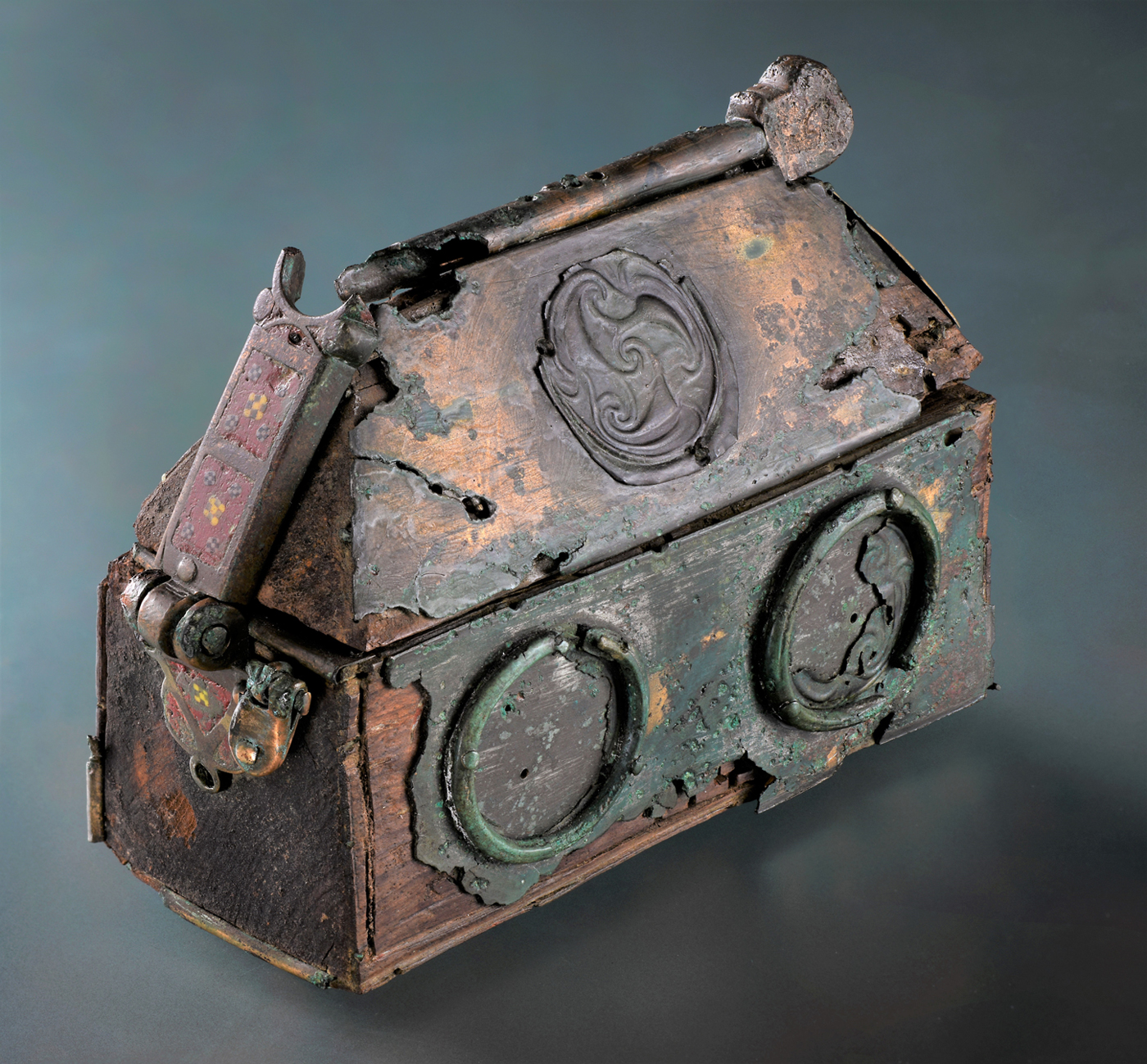
Figure 6. The reliquary from Melhus, Overhalla, (length: 118 mm; height: 83 mm) is one of only twelve complete Insular house-shaped shrines to have survived in Europe.
The overall finds concentration falls within the geographical area of Norway traditionally referred to as ‘Nordafjells’, representing the area north and west of Langfjella, a mountain chain on the southern Norwegian peninsula. These mountains separated the Nordmenn—the men from the north—from the Austmenn, the men from east of the mountains. This geographical division probably stems from at least the Viking Age (Skre, Reference Skre2014: 34–35). Apart from two finds from Farmen and Svennevik, the area ‘east of the mountains’ is remarkably lacking in early Insular finds. The overall distribution pattern clearly strengthens the impression that these objects reached Norway along a direct route over the North Sea, rather than via Denmark and continental Europe. This is further supported by the lack of early finds of Insular metalwork from Denmark (see Baastrup, Reference Baastrup2013).
The sailing route which connected the lands north of the mountains was called Nordvegr, ‘the northern way’ and stretched for more than 1000 km from Rogaland in the south-west to Lofoten, north of the Arctic circle (Skre, Reference Skre2014: 35). In this part of Scandinavia, seafarers mastered ‘shipbuilding, seamanship and naval warfare to a level that was difficult to match for anyone in Northern Europe’ (Skre, Reference Skre2014: 43). The most northerly find in our finds group, a bowl from a cemetery at Ytre Kvarøy (Figure 7), is located just to the south of where the traveller Othere, who visited the court of King Alfred in the late ninth century, is reported to have come from (Storli, Reference Storli, Bately and Englert2007: 81–84). This may also be one of the earliest finds in the current study, based on the early type of decorated sword (Petersen special type 1) found together with the bowl in a plough furrow. The sword is discussed by Vinsrygg (Reference Vinsrygg1979: 67–69), who has identified it as a probable import from the Frankish Rhine area and suggests a deposition date towards the middle or late eighth century. This date fits well with the other eleven graves from this cemetery which are typologically dated from the late sixth to the end of the eighth century (Vinsrygg, Reference Vinsrygg1979: tables I–VIII). Further imported finds from Ytre Kvarøy included cowry shells from the Maldives, a piece of gold-plated metalwork with a Latin inscription, as well as beads and brooches probably produced in southern Scandinavians towns such as Ribe and Birka (Vinsrygg, Reference Vinsrygg1979: 67–70; Sindbæk, Reference Sindbæk, Graham-Campbell, Sindbæk and Williams2011: 58–59). These finds show that the population of a small northern Norwegian island had the means, seafaring skills and connections to acquire objects from far-away places.
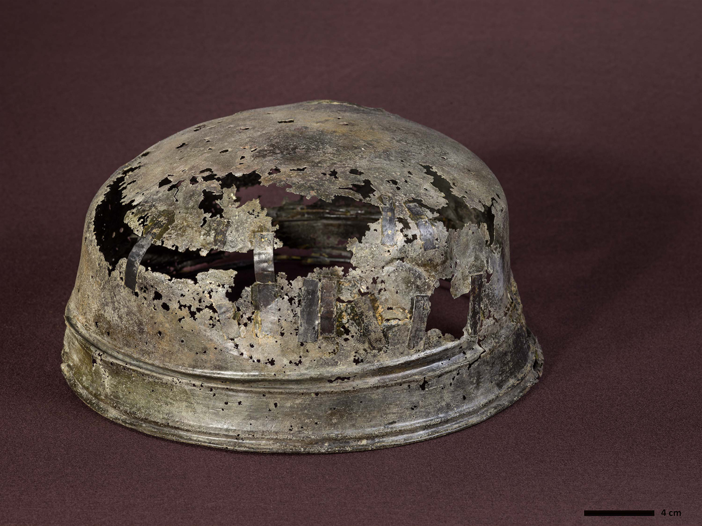
Figure 7. The large bowl from Ytre Kvarøy, Lurøy, is the most northerly find of early Insular metalwork from Norway. Bowl diameter: 31 cm.
The early maritime mobility of these parts of Norway is further emphasized by the presence of reindeer antler, used for comb making which was recovered from early town layers in Ribe, indicating the existence of direct trade links already from the late eighth century (Ashby et al., Reference Ashby, Coutu and Sindbæk2015). Likewise, Baug et al. (Reference Baug, Skre, Heldal and Jansen2018) have recently shown how there was a ‘steady supply’ of ‘Mostadmarka’ type whetstones from Trøndelag to markets in southern Scandinavia from at least the early eighth century. These results also suggest increasing economic activity in the North Sea area which drew large parts of Norway into supra-regional networks in the decades before and after the first recorded Viking attacks (as underlined by Myhre, Reference Myhre, Faulkes and Perkins1993, and Baug et al., Reference Baug, Skre, Heldal and Jansen2018). Frisian Tating ware is found as far north as Borg in Lofoten (Holand, Reference Holand, Munch, Johansen and Roesdahl2003: 203–09), and seventh- and eighth-century Frankish coins were recently recovered in excavations at Ranheim, Trøndelag (Grønnesby & Heen-Pettersen, Reference Grønnesby and Heen-Pettersen2015: 176). Further, the Skei burial mentioned earlier contained fragments of rare Frankish textiles as well as a Berdal 1A brooch probably produced in Ribe (Stenvik, Reference Stenvik2001: 31–37). Through such long-distance voyages, Scandinavians along the Nordvegr became well aware of the Insular lands, either first-hand (as demonstrated by the incident in Dorset, possibly carried out by men from Hordaland), or through information gained second-hand on their journeys to continental Europe. This activity not only moved goods, it also facilitated the movement of knowledge and improved navigational ability, which ultimately may have encouraged voyages of exploration further west over the sea (see Sindbæk, Reference Sindbæk, Graham-Campbell, Sindbæk and Williams2011: 58–59).
Environmental Knowledge and the Earliest North Sea Crossings
An awareness of the Insular land through increased interaction with continental Europe would not have been enough to transform the North Sea passage from a body of water to ‘the highway to the Irish Sea’ (to borrow an expression used by Barrett, Reference Barrett, Anderson, Barrett and Boyle2010: 297). This process also involved a phase where people along the Nordvegr started to travel in unfamiliar maritime environments and, therefore, had to acquire and make use of new environmental knowledge. This issue is often implied in discussions concerning the earliest Viking activity but is rarely considered as a primary factor in the origin of the Viking Age. Rockman (Reference Rockman, Rockman and Steele2003: 4–9) has emphasized the need to examine the importance of different types of environmental knowledge when constructing general models of movement in archaeological research; and, in the following, I will consider the importance of two of these aspects: locational and social knowledge (Rockman, Reference Rockman, Rockman and Steele2003: 13–14). While primarily developed as a tool in colonisation archaeology, a modified version of this model may prove fruitful as a framework for conceptualizing the nature of the earliest North Sea crossings.
Locational knowledge refers to knowledge of the spatial and physical characteristics of new landscapes and particular resources present in new environments. It includes the ability to find places and resources again after their initial discovery (Rockman, Reference Rockman, Rockman and Steele2003: 4–5). For the earliest Viking raiders, this included locational information of desired resources and favourable locations to attack, such as lightly defended places with accumulated portable wealth and potential slaves. It also comprised the right maritime skills and nautical knowledge needed to cross the North Sea and move around in the challenging coastal waters of the Northern British Isles. Locational knowledge is closely linked to social knowledge, where the latter may be understood as the processes and experiences that serve as a means of transforming unfamiliar environments into a social landscape, for instance through the attribution of names, meaning, and experiences to landscapes features in a new environment (Rockman, Reference Rockman, Rockman and Steele2003: 5–7). This approach is comparable to Sindbæk's concept of ‘routinisation’ in the Viking Age, which emphasizes how establishing geographical routes was very much a matter of social practice that had to be experienced and ‘worked out’ (Sindbæk, Reference Sindbæk2005: 32, 274–75).
For Scandinavians in the eighth and early ninth centuries, expeditions to the west must have been daunting experiences, when ‘relatively small open vessels, in the beginning probably with quite limited ability to survive severe weather, carried fairly small groups of men with few provisions’ (Bill, Reference Bill and Klæsøe2010: 38). The passage from western Norway to the Northern Isles is approximately 170 nautical miles long and, with the use of sail in good weather conditions, the crossing could have taken a day or two (Wamers, Reference Wamers, Clarke, Ní Mhaonaigh and Floinn1998: 52). The question of when the sail was adopted in the Norse homelands and how this affected the beginning of the earliest overseas voyages has been hotly debated. Some scholars support the idea that sails were used in Scandinavia long before the Viking Age, while a mid to late eighth-century date has been the generally accepted opinion (see Bill, Reference Bill and Klæsøe2010; Westerdal, Reference Westerdahl, Barrett and Gibbons2015: 18). One of the two vessels discovered at Salme in Estonia in 2008 and 2010, dates to around ad 750 and is the earliest evidence of a combined rowing/sailing vessel used by the Scandinavians (Price et al., Reference Price, Peets, Allmäe, Maldre and Oras2016). For Norway, the use of sail is not archaeologically attested before the Oseberg ship which was constructed in ad 820 (Bill, Reference Bill and Klæsøe2010: 27–28), although it is unlikely to have been the first sailing vessel in Norwegian waters. Nevertheless, the introduction of the sail and developments in shipbuilding technology during the Viking Age in this setting should be regarded as improvements and adaptions in response to new uses rather than the result of revolutionary inventions (Barrett, Reference Barrett, Anderson, Barrett and Boyle2010: 290).
While Denmark and continental Europe could largely be reached by sea passages in sight of land, the situation was quite different when crossing the open North Sea, where land could at times remain out of sight for days. Undertaking such a journey represented a far greater risk and required different skills and methods for estimating a ship's position and speed, such as latitude sailing achieved by using the sun and the stars to estimate direction. Successful landings and return voyages also involved knowledge of the northerly coastline and the behaviours of the North Sea currents to avoid drifting off course or arriving in hostile environments (Van de Noort, Reference Van de Noort2011: 141). This was very much a cognitive and personal experience: ‘Memorized characteristics of coasts and waters, helped along by descriptive toponyms, were essential navigation aids, and pilots with local knowledge were always valuable’ (Bill, Reference Bill, Brink and Price2008: 178–79). This practice is especially visible in Orkney and mainland Scotland, where a large number of Norse landmarks are named after their distinctive features visible from the sea (see Jesch, Reference Jesch, Dekker, Olsen and Hofstra2009 for examples). Many of these probably reflect ‘the voyages that preceded settlement’ and expresses the visual perception and geographical knowledge of the early Norse seafarers (Jesch, Reference Jesch, Dekker, Olsen and Hofstra2009: 78). Maritime-oriented communities, such as the Nordvegr, must have been especially receptive to the cognitive character of such environmental learning (Bill, Reference Bill, Brink and Price2008: 179; Van de Noort, Reference Van de Noort2011: 136–42).
The North Sea was very much a fluctuating and unpredictable force, which was given an ‘other-than-human’ agency with its own will, intentions, and emotions (Van de Noort, Reference Van de Noort2011: 231–33). After navigating this open seascape, the shortest and most direct route would take the Norwegian seafarers to the archipelagic waters of Shetland or Orkney, an area with persistent sea fogs, strong tidal currents, and many skerries and submerged reefs (Crawford, Reference Crawford1987: 19–23). Some of the dangers of sailing in northern waters are expressed in a number of eleventh- to thirteenth-century poems and sagas which describe the hazardous conditions facing seafarers, as well as the wrecks of ships and ships caught in storms (see Jesch, Reference Jesch, Barrett and Gibbons2015). For instance, the waters of the southern tip of Shetland are known as Dynrøst (roaring whirlpool), where tidal currents and strong winds have caused difficulties for many sailors. According to The Saga of Håkon Håkonsson, this is where Harald Olavsson, King of Man, and his bride Cecilia (the daughter of King Håkon Håkonsson) probably drowned when their ship was lost in ad 1248 (HHS: 295, chp. 261). The seafarers who sailed south from Orkney to mainland Scotland also had to avoid the whirlpool Svelkie in the Pentland Firth, one of the most powerful tidal currents in the world. Many ships are known to have been lost there, possibly also that of Earl Håkon of Lade, which The Saga of Olaf Haraldsson tells us disappeared in this area when returning to Norway from England in ad 1029 (Crawford, Reference Crawford1987: 21; OHS, chp. 184).
Without doubt, there must have been many other Scandinavians who met a similar fate along the coasts of Britain and Ireland, and the success of the earliest wave of Vikings must have depended on an intimate knowledge of the maritime landscape along the northern coastline. Wayfinding based on such cognitive mapping was not a skill acquired overnight, but emerged over time as a dynamic process where new information was gradually added in the minds of individuals (see Golledge, Reference Golledge, Rockman and Steele2003: 31–33). Consequently, and following Rockman (Reference Rockman, Rockman and Steele2003: 4–5) and Sindbæk (Reference Sindbæk2005: 30–33), as more knowledge was accumulated and natural features in the new land named and understood, the journey became routinized and the Insular land was gradually transformed from an unfamiliar territory to a socialized landscape.
A revised model of movement
Do the observations made above allow us to propose a revised model of movement and maritime communication for the earliest voyages to northern Britain and Ireland?
First, regarding chronology, it is clear that we still lack the methods and conclusive archaeological material that would provide a fine dating of the earliest evidence of Viking North Sea crossings. However, it is argued here that the revised status of the ‘reindeer comb evidence’ should be incorporated into a current model of contact.
Second, concerning the importance of maritime communication, the distribution analysis has shown that most of the early Insular finds are found in areas along the Nordvegr, which indicates early maritime mobility and sometimes early links with urban networks further south in Scandinavia. This observation is in accordance with Sindbæk's (Reference Sindbæk, Graham-Campbell, Sindbæk and Williams2011) and Baug et al.’s (Reference Baug, Skre, Heldal and Jansen2018) suggestions that pre-Viking journeys to such urban markets may have facilitated the movement of knowledge and improved maritime mobility, which ultimately led to the Viking expansion.
Finally, it has been argued here that the earliest recorded Viking attacks were only possible after a phase in which people along the Nordvegr had acquired a sufficient level of environmental knowledge to navigate in new seascapes and coastal environments. It also included the ability to re-locate places with accumulated wealth and resources after their initial discovery. As Purcell (Reference Purcell, Clarke and Johnson2015, 54) puts it, the questions involved were ‘where the target sites were in relation to one another; how to get there; how long it would take; what supplies were necessary to conduct the attack and to ensure sufficient resources to complete the return journey, or indeed to make it to the next target.’
When constructing a model of maritime movement, these observations may be formalized, although somewhat simplified, as a suggested process involving three main stages:
1. Information stage: Seafarers along the Nordvegr became increasingly informed about the Insular land on their journeys to markets further south in Scandinavia and continental Europe (around ad 750/770)
2. Environmental learning: Consequently, this activity triggered maritime expansion, ultimately leading to voyages of exploration further west over the sea, where some seafarers gained first-hand experience with the sea routes and maritime landscape along northern Britain and Ireland (around ad 770/790)
3. The earliest recorded raids: The attack on Lindisfarne and other targets off the coast of Ireland and Britain from ad 793 onwards could only have happened after a period of reconnaissance and preparation. This necessarily involved a level of a priori environmental knowledge and perhaps also a conceptual ‘conquest’ of the open seascape.
While the nature of the second phase of ‘environmental learning’ would leave few traces in the archaeological material, it also opens the possibility that some of the earliest Insular metalwork may have reached Norway as a result of such contact, presuming that this stage could involve small-scale exchange or even plunder. While clearly favouring the notion of pre-Lindisfarne communication, this model does however not suggest that there was a long period of well-established migration and trade between Norway and the northern Insular areas from as far back as the early to mid-eighth century.
Through these early voyages, seafarers developed the necessary environmental knowledge, which, in addition to a range of social and political causes (see Barrett, Reference Barrett, Anderson, Barrett and Boyle2010; Ashby, Reference Ashby2015; Baug et al, Reference Baug, Skre, Heldal and Jansen2018 for recent summaries or discussions), must have been a vital precondition for the successful attacks from the last decade of the eighth century onwards. These experiences were materialized in distinctive foreign goods brought back to the Norse homelands, creating a visual distinction between families involved in overseas ventures and others within their community (Aannestad, Reference Aannestad2015).
Concluding thoughts
While this article has proposed an interaction model which opens up a period of Pre-Viking contact, it is primarily with the first recorded raids from AD 793 onwards, that the Viking activity on Insular land becomes visible. Indeed, much of our modern image of the earliest interaction across the North Sea is affected by the numerous references to the devastation and chaos caused by ‘Gentiles’, ‘Northmen’ and ‘Danes’ in the late eight and early ninth centuries. However, the written sources concerning the ‘earliest wave’ of Viking activity give the impression of well-organized attacks were at least some of the crewmembers must have had first-hand experience with the sea route across the North Sea, the northerly coastline and favourable locations to attack. As such, the success of the earliest raids was not purely the result of superior warfare techniques and ship technology, but also very much a matter of maritime mobility and environmental knowledge where open-sea crossings were encouraged by ‘motivation and the related human factors such as people's knowledge of the sea, their skills, willingness to embrace risk and desire to explore’ (Dugmore et al., Reference Dugmore, Casely, Keller, Mcgovern, Anderson, Barrett and Boyle2010: 213). As shown by the distribution of the earliest Insular finds from Norway, such motivation seems to have been particularly strong amongst the seafaring communities along the Nordvegr.
Acknowledgements
I am most grateful to the four anonymous referees for their constructive and useful feedback, and to Martin Callanan, Unn Pedersen, Randi Bjørshol Wærdahl and Philip Wood for their valuable help in commenting on the original draft of the paper.

