Hostname: page-component-cd9895bd7-dzt6s Total loading time: 0 Render date: 2024-12-27T09:11:56.696Z Has data issue: false hasContentIssue false

A critical review on applications of hyperspectral remote sensing in crop monitoring

Published online by Cambridge University Press:  25 July 2022

Huan Yu*
Affiliation:
College of Earth Sciences, Chengdu University of Technology, 610059, Chengdu, China
Bo Kong
Affiliation:
Institute of Mountain Hazards and Environment, Chinese Academy of Sciences, 610041, Chengdu, China
Yuting Hou
Affiliation:
College of Earth Sciences, Chengdu University of Technology, 610059, Chengdu, China
Xiaoyu Xu
Affiliation:
Department of Geography and Environmental Resources, Southern Illinois University Carbondale, Carbondale, IL 62901, USA Environmental Resources and Policy, Southern Illinois University Carbondale, Carbondale, IL 62901, USA
Tao Chen
Affiliation:
College of Earth Sciences, Chengdu University of Technology, 610059, Chengdu, China
Xiangmeng Liu
Affiliation:
College of Earth Sciences, Chengdu University of Technology, 610059, Chengdu, China
*
*Corresponding author. Email: yuhuan0622@126.com
Rights & Permissions [Opens in a new window]

Summary

Numerous technologies have contributed to the recent development of agriculture, especially the advancement in hyperspectral remote sensing (HRS) constituted a revolution in crop monitoring. The widespread use of HRS to obtain crop parameters suggests the need for a review of research advances in this area. HRS offers new theories and methods for studying crop parameters, but much work needs to be done both experimentally and theoretically before we can truly understand the physical and chemical processes that predict these crop parameters. The study focuses on the following elements: 1) The article provides a relatively comprehensive introduction to HRS and how it can be applied to crop monitoring; 2) Current state-of-the-art techniques are summarized and analyzed to inform further advances in crop monitoring; 3) Opportunities and challenges for crop monitoring applications using HRS are discussed, and future research is summarized. Finally, through a comprehensive discussion and analysis, the article proposes new directions for using HRS to study crop characteristics, such as new data mining techniques including deep learning provide opportunities for efficient processing of large amounts of HRS data; combining the temporal and dynamic characteristics of crop parameters and vegetation growth processes will greatly improve the accuracy of crop parameter detection and monitoring; multidata fusion and multiscale data assimilation will become HRS monitoring. Multidata fusion and multiscale data assimilation will become another research hotspot for HRS monitoring of crop parameters.

Type
Review
Copyright
© The Author(s), 2022. Published by Cambridge University Press

Introduction

Precision farming or precision agriculture is based on using the inherent spatial and temporal variability in a field as a basis to manage farm operations (Goel et al., Reference Goel, Prasher, Landry, Patel, Bonnell, Viau and Miller2003). It is a management practice made possible by the advent of suitable information technologies (Ryu et al., Reference Ryu, Suguri and Umeda2009; Roslim et al., Reference Roslim, Juraimi, Che’Ya, Sulaiman, Abd Manaf, Ramli and Motmainna2021). Regarding time-effective methods, the practice of precision farming requires the development of accurate and reliable crop monitoring techniques to provide information on the spatial and temporal variations in key agronomic parameters (Steven, Reference Steven2004). A comprehensive review on status of various components for precision farming and application of information technology was presented by Plant (Reference Plant2001). He clearly highlighted the importance of high-altitude remote sensing to obtain information on crop growth condition. Remote sensing is a useful tool for monitoring spatial and temporal variation in crop morphology and physiological conditions and for supporting precision agriculture practices (Lu et al., Reference Lu, Dao, Liu, He and Shang2020).

Traditional methods for detecting and monitoring essential parameters of crops need detailed sampling, time, and expensive laboratory chemical analyses, which is neither economically viable nor environmentally acceptable on a large scale (Mahajan et al., Reference Mahajan, Pandey, Sahoo, Gupta, Datta and Kumar2017). Remote sensing can be used to collect information at vastly larger spatial extents more quickly and more cheaply per unit area than field sampling (Flynn et al., Reference Flynn, Frazier and Admas2020). It can also be combined with field data to more efficiently assess spatial and temporal distributions of crop parameters (Aneece et al., Reference Aneece, Epstein and Lerdau2017; Afrasiabian et al., Reference Afrasiabian, Noory, Mokhtari, Nikoo, Pourshakouri and Haghighatmehr2021). Over the past three decades, remote sensing techniques have been used as very useful tools to precisely monitor crops throughout their growing season to support decisions for good agricultural practices (Astor et al., Reference Astor, Dayananda, Nautiyal and Wachendorf2020).

Although the remote sensing technique is widely used for timely detection of variations in the spectral response of crops over large areas, the multispectral remote sensors exhibit serious limitations to accurately detect changes in crop because of coarse spectral resolutions that hide detailed information of signals from crop parameters (Hong and Abd El-Hamid, Reference Hong and Abd El-Hamid2020). Early multispectral images are limited by spectral resolution, which affects the accuracy of retrieval variables and leads to the inability to detect early signals of crop stress in a timely and effective manner (Ang and Seng, Reference Ang and Seng2021). Hyperspectral remote sensing (HRS), also known as imaging spectroscopy or hyperspectral imaging (HSI), involves hundreds of spectral narrow bands that are sensitive to distinct biophysical and biochemical characteristics masked by the broad bands of multispectral remote sensing (Goetz Reference Goetz2009; Slonecker et al., Reference Slonecker, Allen, Resmini, Rand and Paine2018; Gao et al., Reference Gao, Meng, Liang, Feng, Ge, Yin, Wu, Cui, Hou, Liu and Xie2019; Meivel and Maheswari, Reference Meivel and Maheswari2021). Thus, advances in HRS provide opportunities for detailed mapping, modeling, and biophysical characterization of crops (Nidamanuri and Zbell, Reference Nidamanuri and Zbell2011). It is more capable of detecting subtle changes in ground cover and its variation over time.

HRS can be used to address the above challenges and facilitate more accurate and timely detection of crop physiological states. The main research is on field and laboratory hyperspectral measurements for monitoring agriculture and vegetation, retrieval of plant traits in leaf and canopy layers from hyperspectral measurements (Berger et al., Reference Berger, Verrelst, Feret, Wang, Wocher, Strathmann and Hank2020; Dobrota et al., Reference Dobrota, Carpa and Butiuc-Keul2021); hyperspectral sensor calibration and product validation for agriculture and vegetation monitoring, product quality validation (Fahey et al., Reference Fahey, Hai, Gardi, Sabatini and Lamb2020; Jia et al., Reference Jia, Chen, Zheng, Wang and Chen2022); statistical and computational methods for agricultural and vegetation monitoring (Murphy et al., Reference Murphy, Boruff, Callow and Flower2020; Ma et al., Reference Ma, Rehman, Zhang, Maki, Tuinstra and Jin2021; Nansen et al., Reference Nansen, Murdock, Purington and Marshall2021); studies for agricultural and vegetation living environments, microbial load, surrounding species, etc. (Santos-Rufo et al., Reference Santos-Rufo, Mesas-Carrascosa, Garcia-Ferrer and Merono-Larriva2020).

HRS advances constitute a revolution in agriculture and in particular, crop monitoring. The widespread use of HRS for crop parameter acquisition suggests the necessity to review the progress of research in this field. The objectives of this paper are a) to discuss the different platforms and sensors of HRS, summarize the methods available for processing and analyzing hyperspectral information, and recent advances in HSI for agricultural applications; b) to discuss and summarize current developments in crop monitoring supported by HRS and to assess the performance of HRS under different applications; c) to further help agricultural researchers and practitioners better understand the advantages and limitations of HSI in agricultural applications and to promote the opportunities and challenges of using HRS for crop monitoring applications.

HRS monitoring platforms and sensors

Remote sensing platform is used to place various remote sensors to detect ground targets from a certain height or distance and to provide technical support and working conditions for the sensors (Zhong et al., Reference Zhong, Hu, Luo, Wang, Zhao and Zhang2020). According to the height of the platform from the ground, it can be divided into three categories: ground platform, airborne platform, and spaceborne platform (Table 1). These remote sensing platforms with different technical performances and working modes form a multilayer and three-dimensional modern remote sensing information acquisition system, which provides a technical guarantee for the completion of thematic or integrated, regional or global, and static or dynamic remote sensing activities. The working height of ground remote sensing platform is generally less than 100 m, which mainly includes vehicle, ship, handle, fixed or movable elevated platform, etc. Airborne remote sensing platform mainly includes balloon, plane, and other aircraft. Plane specially designed or modified as needed is the main platform of airborne remote sensing because of its flexibility, wide observation range, and high measurement accuracy. Spaceborne remote sensing platform mainly includes satellite, space shuttle, and spacecraft, etc. The prominent characteristics of spaceborne remote sensing are high altitude, large observation range, and fast monitoring speed (Wei et al., Reference Wei, Wang, Lu, Liang, Li, Wang, Wang and Cao2021). Satellite is the widely used platform of spaceborne remote sensing, which is suitable for large-scale surface accurate monitoring. With the continuous improvement of sensor resolution, the status of satellite monitoring platform will become more important. Existing or planned satellite HRS platforms are summarized in Table 2. It can be seen that not many satellites are currently in running and are about to be launched, but the progress of research and development has been significantly accelerated in recent years. Furthermore, sensors with higher spatial resolution and wider spectral range have become a trend.

Table. 1. The synoptic scheme chart showing different hyperspectral remote sensing platforms with diverse features
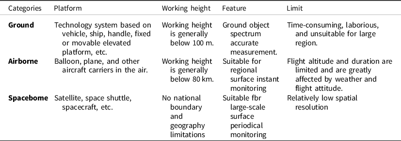
Table 2. Existing or planned satellite hyperspectral remote sensing platforms

Application of HRS in monitoring diverse crop objects

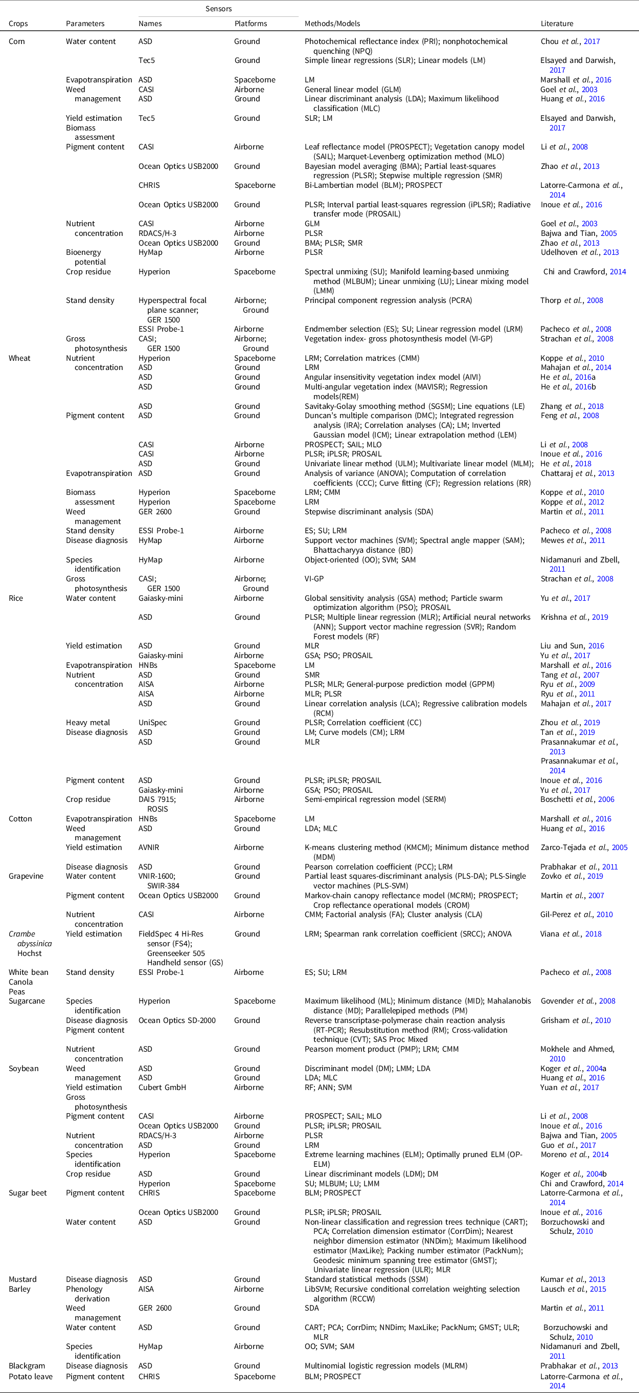
A literature search was performed to examine if more research in using HSI for agricultural purposes had been published in recent years. It was found that there was an increasing number of publications in recent years that used HSI for agricultural applications (Table 3). During 2013–2019, we searched papers on the ‘Web of Science’ website using keywords containing ‘HRS’ and ‘crop’ to find that HRS has been widely used in monitoring of various crops which includes corn (Essayed and Darwish, Reference Elsayed and Darwish2017), wheat (Zhang et al., Reference Zhang, Ren, Zhou, Wu, He, Heng, Feng and Wang2018), rice (Krishna et al., Reference Krishna, Sahoo, Singh, Bajpai, Patra, Kumar, Dandapani, Gupta, Viswanathan, Ahmad and Sahoo2019), cotton (Marshall et al., Reference Marshall, Thenkabail, Biggs and Post2016), grapevine (Zovko et al., Reference Zovko, Žibrat, Knapič, Kovačić and Romić2019), Crambe abyssinica Hochst (Viana et al., Reference Viana, Mercante, de Andrade, Felipetto, Cattani, Bombarda and Boas2018), white bean, canola, peas (Pacheco et al., Reference Pacheco, Bannari, Staenz and McNairn2008), sugarcane (Mokhele and Ahmed, Reference Mokhele and Ahmed2010), soybean (Yuan et al., Reference Yuan, Yang, Li, Wang, Liu, Yu, Feng, Xu, Zhao and Yang2017), sugar beet (Inoue et al., Reference Inoue, Guerif, Baret, Skidmore, Gitelson, Schlerf, Darvishzadeh and Olioso2016), mustard (Kumar et al., Reference Kumar, Vashisth, Sehgal and Gupta2013), barley (Lausch et al., Reference Lausch, Salbach, Schmidt, Doktor, Merbach and Pause2015), blackgram (Prabhakar et al., Reference Prabhakar, Prasad, Desai, Thirupathi, Gopika, Rao and Venkateswarlu2013), and potato leave (Latorre-Carmona et al., Reference Latorre-Carmona, Knyazikhin, Alonso, Moreno, Pla and Yan2014). A chart showing the application domain of HRS in crop monitoring is provided for clear description. These monitoring work takes place in many different places such as North America, Asia, Europe, South America, and Africa, which means that specific crops are widely distributed in certain regions, or different regions have their own concerned crops. Corn, wheat, and rice are the three most widely distributed crops in the world. It also can be seen from these literatures that they are the three most common monitoring objects in the application of HRS technology. However, there are relatively few studies on many other crops, and even many crops which are important for regional economic development have not been studied, e.g., tobacco, tomato, pepper, cucumber, and carrot. There are many types of hyperspectral sensors at present, and similar studies still need to be further conducted in other areas for different crop species.

Table 3. Applications of hyperspectral remote sensing in crop monitoring during 2003–2019
Application of HRS in retrieving key crop parameters

HRS provides an effective means for the extraction of plant parameters (Millan and Azofeifa, Reference Millan and Azofeifa2018; Yu et al., Reference Yu, Kong, Wang, Sun and Wang2018). It also has been widely used in retrieving crop parameters including water content (Chou et al., Reference Chou, Chen, Yu, Chen, Zhang, Croft, Khalid, Li and Shi2017), weed management (Huang et al., Reference Huang, Lee, Thomson and Reddy2016), evapotranspiration (Marshall et al., Reference Marshall, Thenkabail, Biggs and Post2016), yield estimation (Elsayed and Darwish, Reference Elsayed and Darwish2017), heavy metal (Zhou et al., Reference Zhou, Zhang, Zou, Liu, Du, Wang, Liu, Liu and Li2019), bioenergy potential (Udelhoven et al., Reference Udelhoven, Delfosse, Bossung, Ronellenfitsch, Mayer, Schlerf, Machwitz and Hoffmann2013), stand density (Pacheco et al., Reference Pacheco, Bannari, Staenz and McNairn2008), crop residue (Chi and Crawford, Reference Chi and Crawford2014), gross photosynthesis (Yuan et al., Reference Yuan, Yang, Li, Wang, Liu, Yu, Feng, Xu, Zhao and Yang2017), disease diagnosis (Prasannakumar et al., Reference Prasannakumar, Chander and Sahoo2014), phenology derivation (Lausch et al., Reference Lausch, Salbach, Schmidt, Doktor, Merbach and Pause2015), species identification (Moreno et al., Reference Moreno, Corona, Lendasse, Grana and Galvao2014), nutrient concentration (Mahajan et al., Reference Mahajan, Pandey, Sahoo, Gupta, Datta and Kumar2017), biomass assessment, and pigment content (Inoue et al., Reference Inoue, Guerif, Baret, Skidmore, Gitelson, Schlerf, Darvishzadeh and Olioso2016). In order to show the application of HRS in retrieving these parameters more clearly, a chronological diagram was drawn (Figure 1). In summary, pigment content and nutrient concentration were the most common theme in HRS for crop monitoring over decades (Table 3). Over time, the applications of HRS in crop monitoring have been growing and the contents have become more diversified and quantitative. Especially in recent years, the applications of HRS focus on emerging agricultural research domains, such as the heavy metal detecting and water content retrieving. However, most of the study cases were based on ground remote sensing platforms, and there were almost no airborne or spaceborne remote sensing platforms.
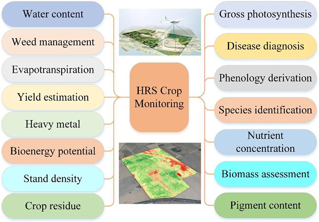
Figure 1. Applications of HRS in retrieving crop parameters (HRS: hyperspectral remote sensing).

Diversified extraction models and methods

It can be seen from the study cases in the past 20 years that various methods or models were used to extract crop parameters (Table 3). In order to clearly show the applications of methods or models, the network diagrams reveal the relationships between applied methods or models with monitoring objects, crop parameters, and monitoring platforms that were explored, respectively. As the three most widely distributed crops, corn, wheat, and rice had received extensive attention; therefore, many methods or models were involved (Xu et al., Reference Xu, Nie, Jin, Li, Zhu, Xu, Wang, Zhao and Feng2021) (Figure 2). A large number of methods or models had been applied to extract nutrient concentration, pigment content, and water content, which also showed that these parameters were concerned by researchers (Figure 3). Because most of the study cases were based on the ground monitoring platform, there were few methods applied to the airborne platform, especially to the spaceborne platform (Figure 4). These methods or models can be summarized into four main categories: linear analysis, non-linear analysis, image classification, and physical model. Linear analysis was the most commonly used method, but physical models were rarely used. A large number of methods reveal that the use of HRS technology for crop monitoring has received widespread attention (Figure 5). However, so many options confuse people in choosing models or methods, which indicates that there is still a need to explore universal quantitative models or methods and extensively apply them to practical work to test the actual effect.
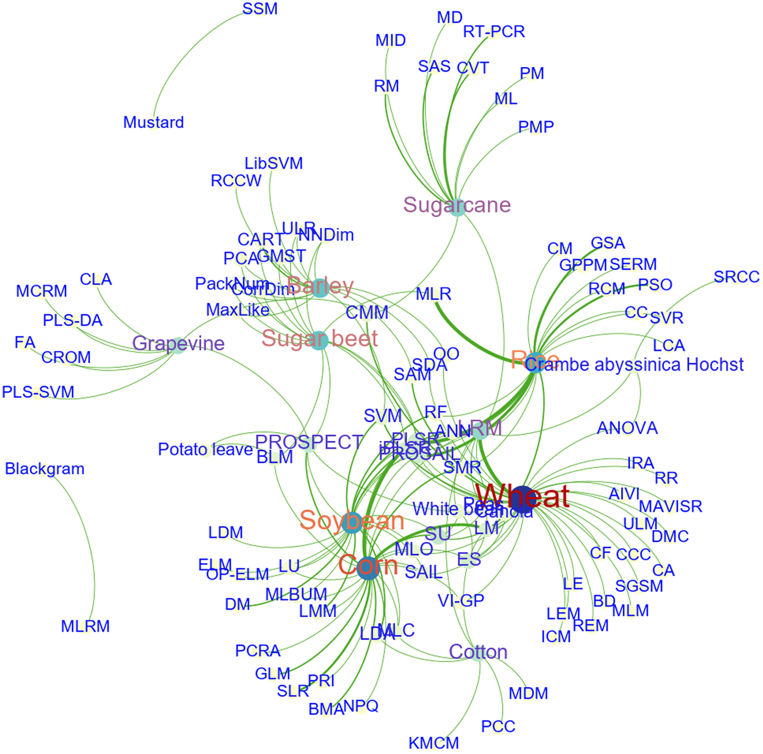
Figure 2. The relationships between objects and applied methods or models.
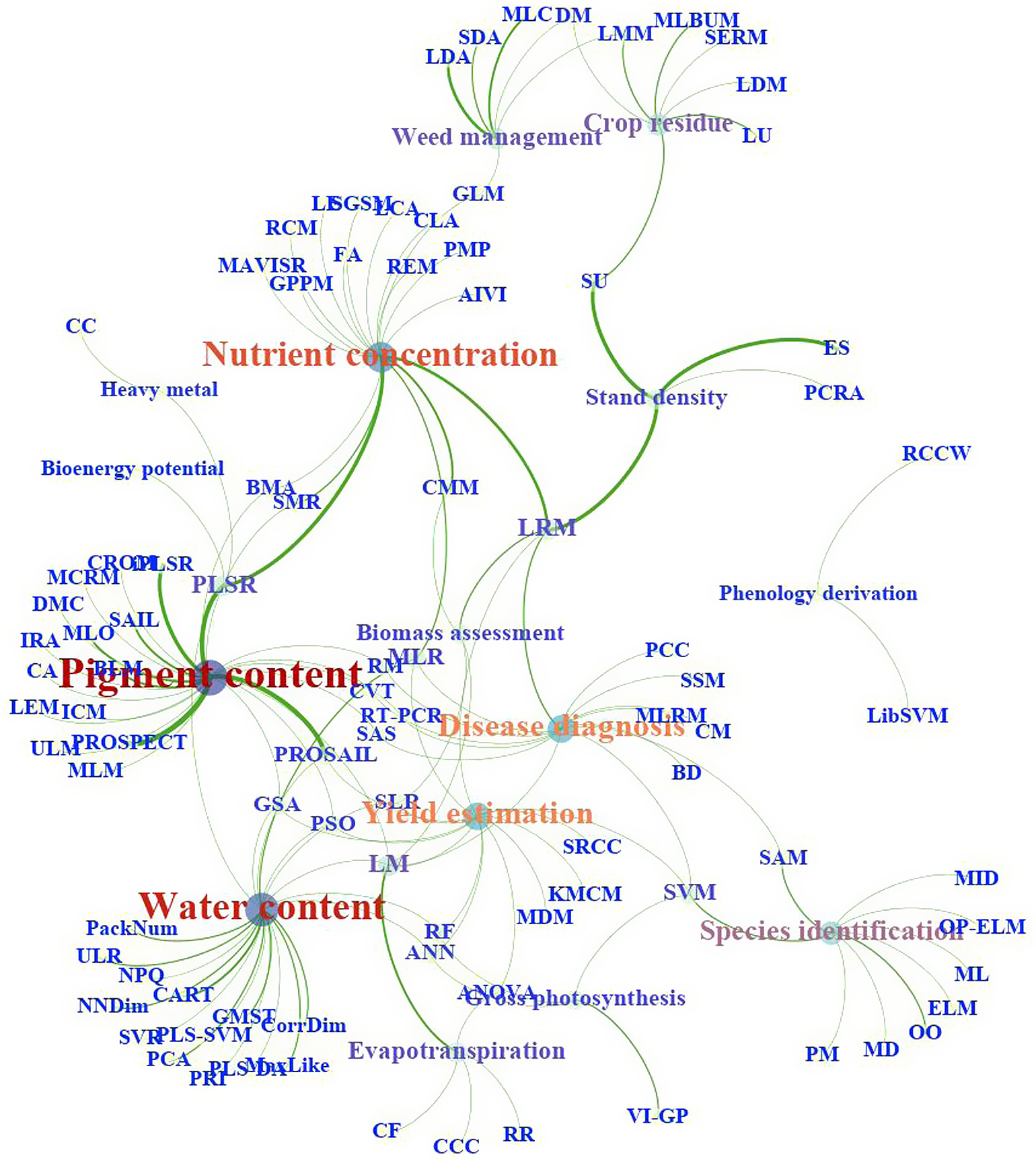
Figure 3. The relationships between parameters and applied methods or models.
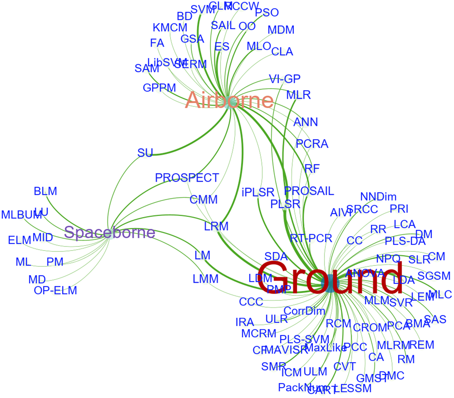
Figure 4. The relationships between platforms and applied methods or models.
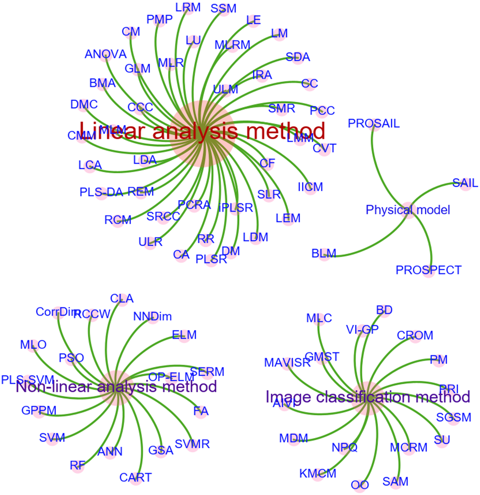
Figure 5. Classification of methods or models by features.

Opportunities and challenges

Although HRS provides new insights of its theory and methodology for studying the crop parameters, there is much work that has to be done both experimentally and theoretically before we can really understand the physical and chemical processes predicting these crop parameters. For example, in terms of data acquisition, the limitations are sensor calibration required; changes in ambient light conditions influence signal and need frequent white reference calibration; and canopy structure and camera geometries or sun angle influence signal. How to effectively achieve HRS data mining, information extraction, high-efficiency data compression and high-speed data transmission is one of the important issues to be solved in the future.

As the resolution of HSI remote sensing sensors increases, more and more dimensions of information are obtained and the volume of data shows significant growth. The limit of employing HRS is the large volume of data that can be generated from spectral images. The large amount of data can make data management particularly important. While acquiring large amounts of hyperspectral image data, one is faced with the problem of how to maximize the use of these massive data. Although some progress has been made in the technology of hyperspectral data classification and information extraction, it still lags behind the development of sensors in general. Therefore, there is still a long way for research on hyperspectral data classification and information extraction.

The current HRS processing methods are particularly rich. On the one hand, new data mining technologies such as deep learning provide opportunities for efficient processing of large amounts of HRS data. Deep learning proposes a method for computer to automatically learn pattern features and incorporates feature learning into the process of model building, thus reducing the incompleteness caused by artificial design features. The findings show that machine learning applications using deep learning as the core method have achieved excellent recognition or classification performance beyond existing algorithms. On the other hand, in view of the huge amount of HRS data, we must extract more effective feature parameters for crop monitoring from the original measurement data. There are two ways to realize this process: band selection and feature extraction. We all know that we should choose those bands with more information, less data correlation, large spectral difference of crop parameters and good separability as the best working bands, and develop feature extraction indexes or methods that are easy to implement with higher extraction accuracy. However, due to the different research objects and regions, the best spectral parameters or characteristic indices of the same crop attribute are also different. Most of the existing spectral indices are based on limited data sets, which makes the monitoring model still lack universality in the selection and application of characteristic parameters.

Specific methods are widely used in building models, including principal component regression analysis, multiple linear regression, partial least-squares regression, stepwise multiple regression, univariate linear method, multivariate linear model, linear correlation analysis, etc. Some studies have explored the methods of nonlinear mathematical analysis, such as support vector machines, nonlinear classification and regression trees technique and artificial neural networks technology. These nonlinear methods can compensate for the shortcomings of linear methods to some extent and improve the prediction accuracy of the model. On the basis of these studies, we should try new artificial intelligence modeling methods such as linear and nonlinear coupling, machine learning and explore their application in crop monitoring. Furthermore, the development from empirical model to physical model will improve the universality and robustness of the model. In addition, in the application of HRS for acquiring crop parameters, more attention should be paid to the application of multivariate models involving multiple parameters, rather than to the single-factor model.

Crop spectra have not only high similarity and spatial variability, but also strong temporal dynamics. The spectral variation of crop parameters with time will be more distinct due to the influence of seasonal characteristics of vegetation. Specifically reflected in the vegetative growth and reproductive growth stages, as well as the staggered stage of vegetative and reproductive growth will cause changes in physical and chemical components and their contribution to spectral reflectance differences. Therefore, by making full use of the advantages of HRS in distinguishing subtle differences of the surface and combining with the temporal and dynamic characteristics of crop parameters, the accuracy of detecting and monitoring of crop parameters will be greatly improved. Further data accumulation and methodological exploration are, however, required to achieve monitoring of crop parameters considering the dynamic process of vegetation growth due to the redundancy of the spectral resolution and the limitation of the temporal resolution of the HRS data, as well as the complexity of the associated models.

With the successful development and launch of ground-based, airborne and spaceborne hyperspectral sensors worldwide, it is easier to obtain reliable and time-sensitive hyperspectral data of the land surface. Moreover, the new features of high spatial resolution, high spectral resolution, and high temporal resolution of HRS technology have become more and more obvious. However, optical HRS means may be affected by many factors such as dust, rust, plowing, particle size distribution, and vegetation coverage, which makes single type of optical HRS data is rather limited and problematic when striving for quantitatively accurate information. Sensors with different working modes and wavelength ranges can provide a variety of detecting means and methods, which can form complementary information to improve monitoring accuracy. For this reason, multidata fusion and multiscale data assimilation will become another research hotspot in HRS monitoring of crop parameters. Fusing hyperspectral data with other types of sensor data, such as Li DAR, SAR, and high spatial resolution images, will have wide application prospects if it can expand the monitoring range or improve the detection accuracy. In addition, with the continuous improvement of temporal and spatial resolution of HRS data and the diversity of data acquisition ways (e.g., ground-based, air borne, and spaceborne), HRS data assimilation has great potential for application. Multiscale data assimilation will improve the monitoring accuracy of land surface process and promote the comprehensive application of multiresolution (temporal, spatial, and spectral) HRS data in agricultural science.

Spaceborne hyperspectral sensors are clearly less used than airborne hyperspectral sensors. Since remote sensing satellite hyperspectral data provide simultaneous views and repeat coverage, two important advantages over ground-based observations and airborne hyperspectral data, research into the potential of satellite hyperspectral data for crop monitoring has become an important issue. Furthermore, the estimation of crop parameters using airborne and satellite hyperspectral sensors is currently limited mainly to small agricultural areas and is still in the testing phase, mainly because the relatively high cost of HSI cameras does not allow for widespread use, which is one of the important issues to be addressed by HRS applications. In addition, the modeling technique used for crop monitoring in most of the previous studies was the simple statistical method, which has several drawbacks related to the physical interpretation of the results and the complexity of transferring the models from one sensor to another (Gomez et al., Reference Gomez, Rossel and McBratney2008; Peón et al., Reference Peón, Fernández, Recondo and Calleja2017). Laboratory and airborne imaging spectroscopy of crop have shown to have considerable potential for the estimation of crop parameters with promising results. However, only a few studies exist that determine crop parameters directly from satellite hyperspectral imagery. Although this approach holds great potential for digital crop mapping with satellite hyperspectral imagery, crop parameter assessment from image data acquired by spaceborne systems is a more difficult issue, mainly due to atmospheric distortions and lower spatial and spectral resolution of the sensors (Mulder et al., Reference Mulder, de Bruin, Schaepman and Mayr2011). In order to be able to fully exploit data from forthcoming hyperspectral satellites, information on several issues related to sensor spatial and spectral resolution and range, as well as on calibration and validation issues, is still required. The development of more physically based models in this context would offer a real step forward towards the generalization of the estimation approaches, but at present still seems an elusive objective (Casa et al., Reference Casa, Castaldi, Pascucci, Palombo and Pignatti2013).

Acknowledgements

This research was funded by the National Natural Science Fundation of China (grant no. 41971226; 41871357), National Basic Research Program of China (2017YFC1503103), and the Strategic Priority Research Program of the Chinese Academy of Sciences (XDA19030303, XDA28110503).

Conflict of Interest

The authors have declared no conflict of interest.

References

Afrasiabian, Y., Noory, H., Mokhtari, A., Nikoo, M.R., Pourshakouri, F. and Haghighatmehr, P. (2021). Effects of spatial, temporal, and spectral resolutions on the estimation of wheat and barley leaf area index using multi- and hyper-spectral data (case study: Karaj, Iran). Precision Agriculture 22, 660688. https://doi.org/10.1007/s11119-020-09749-9 CrossRefGoogle Scholar
Aneece, I.P., Epstein, H. and Lerdau, M. (2017). Correlating species and spectral diversities using hyperspectral remote sensing in early-successional fields. Ecology & Evolution 7, 34753488. https://doi.org/10.1002/ece3.2876 CrossRefGoogle ScholarPubMed
Ang, L.M. and Seng, J. (2021). Big data and machine learning with hyperspectral information in agriculture. IEEE Access PP, 11. https://doi.org/10.1109/ACCESS.2021.3051196 Google Scholar
Astor, T., Dayananda, S., Nautiyal, S. and Wachendorf, M. (2020). Vegetable crop biomass estimation using hyperspectral and RGB 3D UAV data. Agronomy-Basel 10. https://doi.org/10.3390/agronomy10101600 Google Scholar
Bajwa, S.G. and Tian, L.F. (2005). Soil fertility characterization in agricultural fields using hyperspectral remote sensing. Transactions of the Asae 48, 23992406. https://doi.org/10.13031/2013.20079 CrossRefGoogle Scholar
Berger, K., Verrelst, J., Feret, J.-B., Wang, Z., Wocher, M., Strathmann, M. and Hank, T. (2020). Crop nitrogen monitoring: recent progress and principal developments in the context of imaging spectroscopy missions. Remote Sensing of Environment 242. https://doi.org/10.1016/j.rse.2020.111758 CrossRefGoogle Scholar
Borzuchowski, J. and Schulz, K. (2010). Retrieval of leaf area index (LAI) and soil water content (WC) using hyperspectral remote sensing under controlled glass house conditions for spring barley and sugar beet. Remote Sensing 2, 17021721. https://doi.org/10.3390/rs2071702 CrossRefGoogle Scholar
Boschetti, M., Brivio, P.A., Carnesale, D. and Di Guardo, A. (2006). The contribution of hyperspectral remote sensing to identify vegetation characteristics necessary to assess the fate of Persistent Organic Pollutants (POPs) in the environment. Annals of Geophysics 49, 177186. https://doi.org/10.4401/ag-3167 Google Scholar
Casa, R., Castaldi, F., Pascucci, S., Palombo, A. and Pignatti, S. (2013). A comparison of sensor resolution and calibration strategies for soil texture estimation from hyperspectral remote sensing. Geoderma 197–198, 1726. https://doi.org/10.1016/j.geoderma.2012.12.016 CrossRefGoogle Scholar
Chattaraj, S., Chakraborty, D., Garg, R.N., Singh, G.P., Gupta, V.K., Singh, S. and Singh, R. (2013). Hyperspectral remote sensing for growth-stage-specific water uses in wheat. Field Crops Research 144, 179191. https://doi.org/10.1016/j.fcr.2012.12.009 CrossRefGoogle Scholar
Chi, J. and Crawford, M.M. (2014). Spectral unmixing-based crop residue estimation using hyperspectral remote sensing data: a case study at Purdue University. IEEE Journal of Selected Topicsin Applied Earth Observations and Remote Sensing 7, 25312539. https://doi.org/10.1109/JSTARS.2014.2319585 CrossRefGoogle Scholar
Chou, S., Chen, J.M., Yu, H., Chen, B., Zhang, X.Y., Croft, H., Khalid, S., Li, M. and Shi, Q. (2017). Canopy-level photochemical reflectance index from hyperspectral remote sensing and leaf-level non-photochemical quenching as early indicators of water stress in maize. Remote Sensing 9, 794. https://doi.org/10.3390/rs9080794 CrossRefGoogle Scholar
Dobrota, C.T., Carpa, R. and Butiuc-Keul, A. (2021). Analysis of designs used in monitoring crop growth based on remote sensing methods. Turkish Journal of Agriculture and Forestry 45, 730742. https://doi.org/10.3906/tar-2012-79 CrossRefGoogle Scholar
Elsayed, S. and Darwish, W. (2017). Hyperspectral remote sensing to assess the water status, biomass, and yield of maize cultivars under salinity and water stress. Bragantia 76, 6272. https://doi.org/10.1590/1678-4499.018 CrossRefGoogle Scholar
Fahey, T., Hai, P., Gardi, A., Sabatini, R. and Lamb, D.W. (2020). Active and passive electro-optical sensors for health assessment in food crops. Sensors 21, 171. https://doi.org/10.3390/s21010171 CrossRefGoogle ScholarPubMed
Feng, W., Yao, X., Tian, Y., Cao, W. and Zhu, Y. (2008). Monitoring leaf pigment status with hyperspectral remote sensing in wheat. Australian Journal of Agricultural Research 59, 748760. https://doi.org/10.1071/AR07282 CrossRefGoogle Scholar
Flynn, K.C., Frazier, A.E. and Admas, S. (2020). Nutrient prediction for Tef (Eragrostis tef) plant and grain with hyperspectral data and partial least squares regression: Replicating methods and results across environments. Remote Sensing 12. https://doi.org/10.3390/rs12182867 CrossRefGoogle Scholar
Gao, J., Meng, B., Liang, T., Feng, Q., Ge, J., Yin, J., Wu, C., Cui, X., Hou, M., Liu, J. and Xie, H. (2019). Modeling alpine grassland forage phosphorus based on hyperspectral remote sensing and a multi-factor machine learning algorithm in the east of Tibetan Plateau, China. ISPRS Journal of Photogrammetry and Remote Sensing 147, 104117. https://doi.org/10.1016/j.isprsjprs.2018.11.015 CrossRefGoogle Scholar
Gil-Perez, B., Zarco-Tejada, P.J., Correa-Guimaraes, A., Relea-Gangas, E., Navas-Gracia, L.M., Hernandez-Navarro, S., Sanz-Requena, J.F., Berjon, A. and Martin-Gil, J. (2010). Remote sensing detection of nutrient uptake in vineyards using narrow-band hyperspectral imagery. Vitis 49, 167173. https://doi.org/10.1007/s00122-009-1210-3 Google Scholar
Goel, P.K., Prasher, S.O., Landry, J.A., Patel, R.M., Bonnell, R.B., Viau, A.A. and Miller, J.A. (2003). Potential of airborne hyperspectral remote sensing to detect nitrogen deficiency and weed infestation in corn. Computers and Electronics in Agriculture 38, 99124. https://doi.org/0.1016/S0168-1699(02)00138-2 CrossRefGoogle Scholar
Goetz, A.F.H. (2009). Three decades of hyperspectral remote sensing of the Earth: a personal view. Remote Sensing of Environment 113 (Suppl. 1), S5S16. https://doi.org/10.1016/j.rse.2007.12.014 CrossRefGoogle Scholar
Gomez, C., Rossel, R.A.V. and McBratney, A.B. (2008). Soil organic carbon prediction by hyperspectral remote sensing and field vis-NIR spectroscopy: an Australian case study. Geoderma 146, 403411. https://doi.org/10.1016/j.geoderma.2008.06.011 CrossRefGoogle Scholar
Govender, M., Chetty, K., Naiken, V. and Bulcock, H. (2008). A comparison of satellite hyperspectral and multispectral remote sensing imagery for improved classification and mapping of vegetation. Water SA 34, 147154. https://doi.org/10.4314/wsa.v34i2.183634 CrossRefGoogle Scholar
Grisham, M.P., Johnson, R.M. and Zimba, P.V. (2010). Detecting Sugarcane yellow leaf virus infection in asymptomatic leaves with hyperspectral remote sensing and associated leaf pigment changes. Journal of Virological Methods 167, 140145. https://doi.org/10.1016/j.jviromet.2010.03.024 CrossRefGoogle ScholarPubMed
Guo, R., Zhao, M.Z., Yang, Z.X., Wang, G.J., Yin, H. and Li, J.D. (2017). Simulation of soybean canopy nutrient contents by hyperspectral remote sensing. Applied Ecology and Environmental Research 15, 11851198. https://doi.org/10.15666/aeer/1504_11851198 CrossRefGoogle Scholar
He, L., Song, X., Feng, W., Guo, B.B., Zhang, Y.S., Wang, Y.H., Wang, C.Y. and Guo, T.C. (2016a). Improved remote sensing of leaf nitrogen concentration in winter wheat using multi-angular hyperspectral data. Remote Sensing of Environment 174, 122133. https://doi.org/10.1016/j.rse.2015.12.007 CrossRefGoogle Scholar
He, L., Zhang, H.Y., Zhang, Y.S., Song, X., Feng, W., Kang, G.Z., Wang, C.Y. and Guo, T.C. (2016b). Estimating canopy leaf nitrogen concentration in winter wheat based on multi-angular hyperspectral remote sensing. European Journal of Agronomy 73, 170185. https://doi.org/10.1016/j.eja.2015.11.017 CrossRefGoogle Scholar
He, R.Y., Li, H., Qiao, X.J. and Jiang, J.B. (2018). Using wavelet analysis of hyperspectral remote sensing data to estimate canopy chlorophyll content of winter wheat under stripe rust stress. International Journal of Remote Sensing 39, 40594076. https://doi.org/10.1080/01431161.2018.1454620 CrossRefGoogle Scholar
Hong, G. and Abd El-Hamid, H.T. (2020). Hyperspectral imaging using multivariate analysis for simulation and prediction of agricultural crops in Ningxia, China. Computers and Electronics in Agriculture 172. https://doi.org/10.1016/j.compag.2020.105355 CrossRefGoogle Scholar
Huang, Y.B., Lee, M.A., Thomson, S.J. and Reddy, K.N. (2016). Ground-based hyperspectral remote sensing for weed management in crop production. International Journal of Agricultural and Biological Engineering 9, 98109. https://doi.org/10.3965/j.ijabe.20160902.2137 Google Scholar
Inoue, Y., Guerif, M., Baret, F., Skidmore, A., Gitelson, A., Schlerf, M., Darvishzadeh, R. and Olioso, A. (2016). Simple and robust methods for remote sensing of canopy chlorophyll content: a comparative analysis of hyperspectral data for different types of vegetation. Plant Cell and Environment 39, 26092623. https://doi.org/10.1111/pce.12815 CrossRefGoogle ScholarPubMed
Jia, J., Chen, J., Zheng, X., Wang, Y. and Chen, Y. (2022). Tradeoffs in the spatial and spectral resolution of airborne hyperspectral imaging systems: A crop identification case study. IEEE Transactions on Geoscience and Remote Sensing 60. https://doi.org/10.1109/tgrs.2021.3096999 Google Scholar
Koger, C.H., Shaw, D.R., Reddy, K.N. and Bruce, L.M. (2004a). Detection of pitted morningglory (Ipomoea lacunosa) by hyperspectral remote sensing. I. Effects of tillage and cover crop residue. Weed Science 52, 222229. https://doi.org/10.1614/WS-03-082R CrossRefGoogle Scholar
Koger, C.H., Shaw, D.R., Reddy, K.N. and Bruce, L.M. (2004b). Detection of pitted morningglory (Ipomoea lacunosa) with hyperspectral remote sensing. II. Effects of vegetation ground cover and reflectance properties. Weed Science 52, 230235. https://doi.org/10.1614/WS-03-083R1 CrossRefGoogle Scholar
Koppe, W., Gnyp, M.L., Hennig, S.D., Li, F., Miao, Y.X., Chen, X.P., Jia, L.L. and Bareth, G. (2012). Multi-temporal hyperspectral and radar remote sensing for estimating winter wheat biomass in the North China plain. Photogrammetrie Fernerkundung Geoinformation 3, 281298. https://doi.org/10.1127/1432-8364/2012/0117 CrossRefGoogle Scholar
Koppe, W., Li, F., Gnyp, M.L., Miao, Y.X., Jia, L.L., Chen, X.P., Zhang, F.S. and Bareth, G. (2010). Evaluating multispectral and hyperspectral satellite remote sensing data for estimating winter wheat growth parameters at regional scale in the North China Plain. Photogrammetrie Fernerkundung Geoinformation 3, 167178. https://doi.org/10.1127/1432-8364/2010/0047 CrossRefGoogle Scholar
Krishna, G., Sahoo, R.N., Singh, P., Bajpai, V., Patra, H., Kumar, S., Dandapani, R., Gupta, V.K., Viswanathan, C., Ahmad, T. and Sahoo, P.M. (2019). Comparison of various modelling approaches for water deficit stress monitoring in rice crop through hyperspectral remote sensing. Agricultural Water Management 213, 231244. https://doi.org/10.1016/j.agwat.2018.08.029 CrossRefGoogle Scholar
Kumar, J., Vashisth, A., Sehgal, V.K. and Gupta, V.K. (2013). Assessment of aphid infestation in mustard by hyperspectral remote sensing. Journal of the Indian Society of Remote Sensing 41, 8390. https://doi.org/10.1007/s12524-012-0207-6 CrossRefGoogle Scholar
Latorre-Carmona, P., Knyazikhin, Y., Alonso, L., Moreno, J.F., Pla, F. and Yan, Y. (2014). On hyperspectral remote sensing of leaf biophysical constituents: decoupling vegetation structure and leaf optics using chris-proba data over crops in barrax. IEEE Geoscience and Remote Sensing Letters 11, 15791583. https://doi.org/10.1109/LGRS.2014.2305168 CrossRefGoogle Scholar
Lausch, A., Salbach, C., Schmidt, A., Doktor, D., Merbach, I. and Pause, M. (2015). Deriving phenology of barley with imaging hyperspectral remote sensing. Ecological Modelling 295, 123135. https://doi.org/10.1016/j.ecolmodel.2014.10.001 CrossRefGoogle Scholar
Li, Q.M., Hu, B.X. and Pattey, E. (2008). A scale-wise model inversion method to retrieve canopy biophysical parameters from hyperspectral remote sensing data. Canadian Journal of Remote Sensing 34, 311319. https://doi.org/10.5589/m08-014 Google Scholar
Liu, X.D. and Sun, Q.H. (2016). Early assessment of the yield loss in rice due to the brown plant hopper using a hyperspectral remote sensing method. International Journal of Pest Management 62, 205213. https://doi.org/10.1080/09670874.2016.1174791 CrossRefGoogle Scholar
Lu, B., Dao, P.D., Liu, J., He, Y. and Shang, J. (2020). Recent advances of hyperspectral imaging technology and applications in agriculture. Remote Sensing 12, 2659. https://doi.org/10.3390/rs12162659 CrossRefGoogle Scholar
Ma, D., Rehman, T.U., Zhang, L., Maki, H., Tuinstra, M.R. and Jin, J. (2021). Modeling of diurnal changing patterns in airborne crop remote sensing images. Remote Sensing 13. https://doi.org/10.3390/rs13091719 Google Scholar
Mahajan, G.R., Pandey, R.N., Sahoo, R.N., Gupta, V.K., Datta, S.C. and Kumar, D. (2017). Monitoring nitrogen, phosphorus and sulphur in hybrid rice (Oryza sativa L.) using hyperspectral remote sensing. Precision Agriculture 18, 736761. https://doi.org/10.1007/s11119-016-9485-2 CrossRefGoogle Scholar
Mahajan, G.R., Sahoo, R.N., Pandey, R.N., Gupta, V.K. and Kumar, D. (2014). Using hyperspectral remote sensing techniques to monitor nitrogen, phosphorus, sulphur and potassium in wheat (Triticum aestivum L.). Precision Agriculture 15, 499522. https://doi.org/10.1007/s11119-014-9348-7 CrossRefGoogle Scholar
Marshall, M., Thenkabail, P., Biggs, T. and Post, K. (2016). Hyperspectral narrowband and multispectral broadband indices for remote sensing of crop evapotranspiration and its components (transpiration and soil evaporation). Agricultural and Forest Meteorology 218–219, 122134. https://doi.org/10.1016/j.agrformet.2015.12.025 CrossRefGoogle Scholar
Martin, M.P., Barreto, L., Riano, D., Fernandez-Quintanilla, C. and Vaughan, P. (2011). Assessing the potential of hyperspectral remote sensing for the discrimination of grass weeds in winter cereal crops. International Journal of Remote Sensing 32, 4967. https://doi.org/10.1080/01431160903439874 CrossRefGoogle Scholar
Martin, P., Zarco-Tejada, P.J., Gonzalez, M.R. and Berjon, A. (2007). Using hyperspectral remote sensing to map grape quality in ‘Tempranillo’ vineyards affected by iron deficiency chlorosis. Vitis 46, 714. https://doi.org/0042-7500(2007)46:1<7:UHRSTM>2.0.TX;2-4 Google Scholar
Meivel, S. and Maheswari, S. (2021). Remote sensing analysis of agricultural drone. Journal of the Indian Society of Remote Sensing 49, 689701. https://doi.org/10.1007/s12524-020-01244-y CrossRefGoogle Scholar
Mewes, T., Franke, J. and Menz, G. (2011). Spectral requirements on airborne hyperspectral remote sensing data for wheat disease detection. Precision Agriculture 12, 795812. https://doi.org/10.1007/s11119-011-9222-9 CrossRefGoogle Scholar
Millan, V.G. and Azofeifa, S.A. (2018). Quantifying changes on forest succession in a dry tropical forest using angular-hyperspectral remote sensing. Remote Sensing 10, 1865. https://doi.org/10.3390/rs10121865 CrossRefGoogle Scholar
Mokhele, T.A. and Ahmed, F.B. (2010). Estimation of leaf nitrogen and silicon using hyperspectral remote sensing. Journal of Applied Remote Sensing 4, 043560. https://doi.org/10.1117/1.3525241 Google Scholar
Moreno, R., Corona, F., Lendasse, A., Grana, M. and Galvao, L.S. (2014). Extreme learning machines for soybean classification in remote sensing hyperspectral images. Neurocomputing 128, 207216. https://doi.org/10.1016/j.neucom.2013.03.057 CrossRefGoogle Scholar
Mulder, V.L., de Bruin, S., Schaepman, M.E. and Mayr, T.R. (2011). The use of remote sensing in soil and terrain mapping—a review. Geoderma 162, 119. https://doi.org/10.1016/j.geoderma.2010.12.018 CrossRefGoogle Scholar
Murphy, M.E., Boruff, B., Callow, J.N. and Flower, K.C. (2020). Detecting frost stress in wheat: A controlled environment hyperspectral study on wheat plant components and implications for multispectral field sensing. Remote Sensing 12. https://doi.org/10.3390/rs12030477 CrossRefGoogle Scholar
Nansen, C., Murdock, M., Purington, R. and Marshall, S. (2021). Early infestations by arthropod pests induce unique changes in plant compositional traits and leaf reflectance. Pest Management Science 77, 51585169. https://doi.org/10.1002/ps.6556 CrossRefGoogle ScholarPubMed
Nidamanuri, R.R. and Zbell, B. (2011). Transferring spectral libraries of canopy reflectance for crop classification using hyperspectral remote sensing data. Biosystems Engineering 110, 231246. https://doi.org/10.1016/j.biosystemseng.2011.07.002 CrossRefGoogle Scholar
Pacheco, A., Bannari, A., Staenz, K. and McNairn, H. (2008). Deriving percent crop cover over agriculture canopies using hyperspectral remote sensing. Canadian Journal of Remote Sensing 34, S110S123. https://doi.org/10.5589/m07-064 CrossRefGoogle Scholar
Peón, J., Fernández, S., Recondo, C. and Calleja, J.F. (2017). Evaluation of the spectral characteristics of five hyperspectral and multispectral sensors for soil organic carbon estimation in burned areas. International Journal of Wildland Fire 26, 230239. https://doi.org/10.1071/WF16122 CrossRefGoogle Scholar
Plant, R.E. (2001). Site-specific management: the application of information technology to crop production. Computers and Electronics in Agriculture 30, 929. https://doi.org/10.1016/S0168-1699(00)00152-6 CrossRefGoogle Scholar
Prabhakar, M., Prasad, Y.G., Desai, S., Thirupathi, M., Gopika, K., Rao, G.R. and Venkateswarlu, B. (2013). Hyperspectral remote sensing of yellow mosaic severity and associated pigment losses in Vigna mungo using multinomial logistic regression models. Crop Protection 45, 132140. https://doi.org/10.1016/j.cropro.2012.12.003 CrossRefGoogle Scholar
Prabhakar, M., Prasad, Y.G., Thirupathi, M., Sreedevi, G., Dharajothi, B. and Venkateswarlu, B. (2011). Use of ground based hyperspectral remote sensing for detection of stress in cotton caused by leafhopper (Hemiptera: Cicadellidae). Computers and Electronics in Agriculture 79, 189198. https://doi.org/10.1016/j.compag.2011.09.012 CrossRefGoogle Scholar
Prasannakumar, N.R., Chander, S. and Sahoo, R.N. (2014). Characterization of brown plant hopper damage on rice crops through hyperspectral remote sensing under field conditions. Phytoparasitica 42, 387395. https://doi.org/10.1007/s12600-013-0375-0 CrossRefGoogle Scholar
Prasannakumar, N.R., Chander, S., Sahoo, RN and Gupta, V.K. (2013). Assessment of Brown Planthopper, (Nilaparvata lugens) [Stål], damage in rice using hyperspectral remote sensing. International Journal of Pest Management 59, 180188. https://doi.org/10.1080/09670874.2013.808780 CrossRefGoogle Scholar
Roslim, M.H.M., Juraimi, A.S., Che’Ya, N.N., Sulaiman, N., Abd Manaf, M.N.H., Ramli, Z. and Motmainna, M. (2021). Using remote sensing and an unmanned aerial system for weed management in agricultural crops: A review. Agronomy-Basel 11. https://doi.org/10.3390/agronomy11091809 Google Scholar
Ryu, C., Suguri, M. and Umeda, M. (2009). Model for predicting the nitrogen content of rice at panicle initiation stage using data from airborne hyperspectral remote sensing. Biosystems Engineering 104, 465475. https://doi.org/10.1016/j.biosystemseng.2009.09.002 CrossRefGoogle Scholar
Ryu, C., Suguri, M. and Umeda, M. (2011). Multivariate analysis of nitrogen content for rice at the heading stage using reflectance of airborne hyperspectral remote sensing. Field Crops Research 122, 214224. https://doi.org/10.1016/j.fcr.2011.03.013 CrossRefGoogle Scholar
Santos-Rufo, A., Mesas-Carrascosa, F.-J., Garcia-Ferrer, A. and Merono-Larriva, J.E. (2020). Wavelength selection method based on partial least square from hyperspectral unmanned aerial vehicle orthomosaic of irrigated Olive Orchards. Remote Sensing 12. https://doi.org/10.3390/rs12203426 CrossRefGoogle Scholar
Slonecker, E.T., Allen, D.W., Resmini, R.G., Rand, R.S. and Paine, E. (2018). Full-range, solar-reflected hyperspectral microscopy to support earth remote sensing research. Journal of Applied Remote Sensing 12, 026024. https://doi.org/10.1117/1.JRS.12.026024 CrossRefGoogle Scholar
Steven, M.C. (2004). Correcting the effects of field of view and varying illumination in spectral measurements of crops. Precision Agriculture 5, 5572. https://doi.org/10.1023/B:PRAG.0000013620.61519.86 CrossRefGoogle Scholar
Strachan, I.B., Pattey, E., Salustro, C. and Miller, J.R. (2008). Use of hyperspectral remote sensing to estimate the gross photosynthesis of agricultural fields. Canadian Journal of Remote Sensing 34, 333341. https://doi.org/10.5589/m08-051 Google Scholar
Tan, Y., Sun, J.Y., Zhang, B., Chen, M., Liu, Y. and Liu, X.D. (2019). Sensitivity of a ratio vegetation index derived from hyperspectral remote sensing to the Brown Planthopper stress on rice plants. Sensors 19, 375. https://doi.org/10.3390/s19020375 CrossRefGoogle Scholar
Tang, Y.L., Huang, J.F., Cai, S.H. and Wang, R.C. (2007). Nitrogen contents of rice panicle and paddy by hyperspectral remote sensing. Pakistan Journal of Biological Sciences 10, 44204425. https://doi.org/10.3923/pjbs.2007.4420.4425 Google ScholarPubMed
Thorp, K.R., Steward, B.L., Kaleita, A.L. and Batchelor, W.D. (2008). Using aerial hyperspectral remote sensing imagery to estimate corn plant stand density. Transactions of the Asabe 51, 311320. https://doi.org/10.13031/2013.24207 CrossRefGoogle Scholar
Udelhoven, T., Delfosse, P., Bossung, C., Ronellenfitsch, F., Mayer, F., Schlerf, M., Machwitz, M. and Hoffmann, L. (2013). Retrieving the bioenergy potential from maize crops using hyperspectral remote sensing. Remote Sensing 5, 254273. https://doi.org/10.3390/rs5010254 CrossRefGoogle Scholar
Viana, O.H., Mercante, E., de Andrade, M.G., Felipetto, H., Cattani, C.E.V., Bombarda, F.F. and Boas, M.A.V. (2018). Potential of hyperspectral remote sensing to estimate the yield of a Crambe abyssinica Hochst crop. Journal of Applied Remote Sensing 12, 016023. https://doi.org/10.1117/1.JRS.12.016023 CrossRefGoogle Scholar
Wei, L., Wang, K., Lu, Q., Liang, Y., Li, H., Wang, Z., Wang, Y. and Cao, L. (2021). Crops fine classification in airborne hyperspectral imagery based on multi-feature fusion and deep learning. Remote Sensing 13. https://doi.org/10.3390/rs13152917 Google Scholar
Xu, X., Nie, C., Jin, X., Li, Z., Zhu, H., Xu, H., Wang, J., Zhao, Y. and Feng, H. (2021). A comprehensive yield evaluation indicator based on an improved fuzzy comprehensive evaluation method and hyperspectral data. Field Crops Research 270.  108204. https://doi.org/10.1016/j.fcr.2021.108204 CrossRefGoogle Scholar
Yu, F.H., Xu, T.Y., Du, W., Ma, H., Zhang, G.S. and Chen, C.L. (2017). Radiative transfer models (RTMs) for field phenotyping inversion of rice based on UAV hyperspectral remote sensing. International Journal of Agricultural and Biological Engineering 10, 150157. https://doi.org/10.25165/j.ijabe.20171004.3076 Google Scholar
Yu, H., Kong, B., Wang, G.X., Sun, H. and Wang, L. (2018). Hyperspectral data-based prediction of ecological characteristics for grass species of alpine grasslands. Rangeland Journal 40, 1929. https://doi.org/10.1071/RJ17084 CrossRefGoogle Scholar
Yuan, H.H., Yang, G.J., Li, C.C., Wang, Y.J., Liu, J.G., Yu, H.Y., Feng, H.K., Xu, B., Zhao, X.Q. and Yang, X.D. (2017). Retrieving soybean leaf area index from unmanned aerial vehicle hyperspectral remote sensing: analysis of rf, ann, and svm regression models. Remote Sensing 9, 309. https://doi.org/10.3390/rs9040309 CrossRefGoogle Scholar
Zarco-Tejada, P.J., Ustin, S.L. and Whiting, M.L. (2005). Temporal and spatial relationships between within-field yield variability in cotton and high-spatial hyperspectral remote sensing imagery. Agronomy Journal 97, 641653. https://doi.org/10.2134/agronj2003.0257 CrossRefGoogle Scholar
Zhang, H.Y., Ren, X.X., Zhou, Y., Wu, Y.P., He, L., Heng, Y.R. Feng, W. and Wang, C.Y. (2018). Remotely assessing photosynthetic nitrogen use efficiency with in situ hyperspectral remote sensing in winter wheat. European Journal of Agronomy 101, 90100. https://doi.org/10.1016/j.eja.2018.08.010 CrossRefGoogle Scholar
Zhao, K.G., Valle, D., Popescu, S., Zhang, X.S. and Mallick, B. (2013). Hyperspectral remote sensing of plant biochemistry using Bayesian model averaging with variable and band selection. Remote Sensing of Environment 132, 102119. https://doi.org/10.1016/j.rse.2012.12.026 CrossRefGoogle Scholar
Zhong, Y., Hu, X., Luo, C., Wang, X., Zhao, J. and Zhang, L. (2020). WHU-Hi: UAV-borne hyperspectral with high spatial resolution (H-2) benchmark datasets and classifier for precise crop identification based on deep convolutional neural network with CRF. Remote Sensing of Environment 250. https://doi.org/10.1016/j.rse.2020.112012 CrossRefGoogle Scholar
Zhou, W.H., Zhang, J.J., Zou, M.M., Liu, X.Q., Du, X.L., Wang, Q., Liu, Y.Y., Liu, Y. and Li, J.L. (2019). Prediction of cadmium concentration in brown rice before harvest by hyperspectral remote sensing. Environmental Science and Pollution Research 26, 18481856. https://doi.org/10.1007/s11356-018-3745-9 CrossRefGoogle Scholar
Zovko, M., Žibrat, U., Knapič, M., Kovačić, M.B. and Romić, D. (2019). Hyperspectral remote sensing of grapevine drought stress. Precision Agriculture 20, 335347. https://doi.org/10.1007/s11119-019-09640-2 CrossRefGoogle Scholar
Figure 0

Table. 1. The synoptic scheme chart showing different hyperspectral remote sensing platforms with diverse features

Figure 1

Table 2. Existing or planned satellite hyperspectral remote sensing platforms

Figure 2

Table 3. Applications of hyperspectral remote sensing in crop monitoring during 2003–2019

Figure 3

Figure 1. Applications of HRS in retrieving crop parameters (HRS: hyperspectral remote sensing).

Figure 4

Figure 2. The relationships between objects and applied methods or models.

Figure 5

Figure 3. The relationships between parameters and applied methods or models.

Figure 6

Figure 4. The relationships between platforms and applied methods or models.

Figure 7

Figure 5. Classification of methods or models by features.