Regional survey by the Rio Frio Regional Archaeological Project (RiFRAP) in the Mountain Pine Ridge Forest Reserve, Belize has revealed the presence of a landscape-scale ancient Maya granitic-rock extraction and ground stone tool crafting industry. The items made from the rock originating there supplied Maya people throughout the central Maya region (Belize, northern Guatemala, and Quintana Roo and Campeche, Mexico) with many of their manos, metates, and other granite ground stone tools (GST) (see introductory article by Brouwer Burg et al. in this Compact Section; also Abramiuk and Meurer Reference Abramiuk and Meurer2006; Graham Reference Graham1987; Gunn et al. Reference Gunn, Folan and del Rosario Domínguez Carrasco2020; Halperin et al. Reference Halperin, Lopez, Salas and LeMoine2020; Hansen et al. Reference Hansen, Suyuc, Guenter, Morales-Aguilar, Hernández, Balcárcel, Masson, Freidel, Demarest, Chase and Chase2020; Shipley and Graham Reference Graham1987; Tibbits Reference Tibbits2016; Tibbits et al. Reference Tibbits, Peuramaki-Brown, Burg, Tibbits and Harrison-Buck2023). The granitic GST quarry-workshop sites discussed here are the first of their kind reported in the Maya Lowlands.
Background
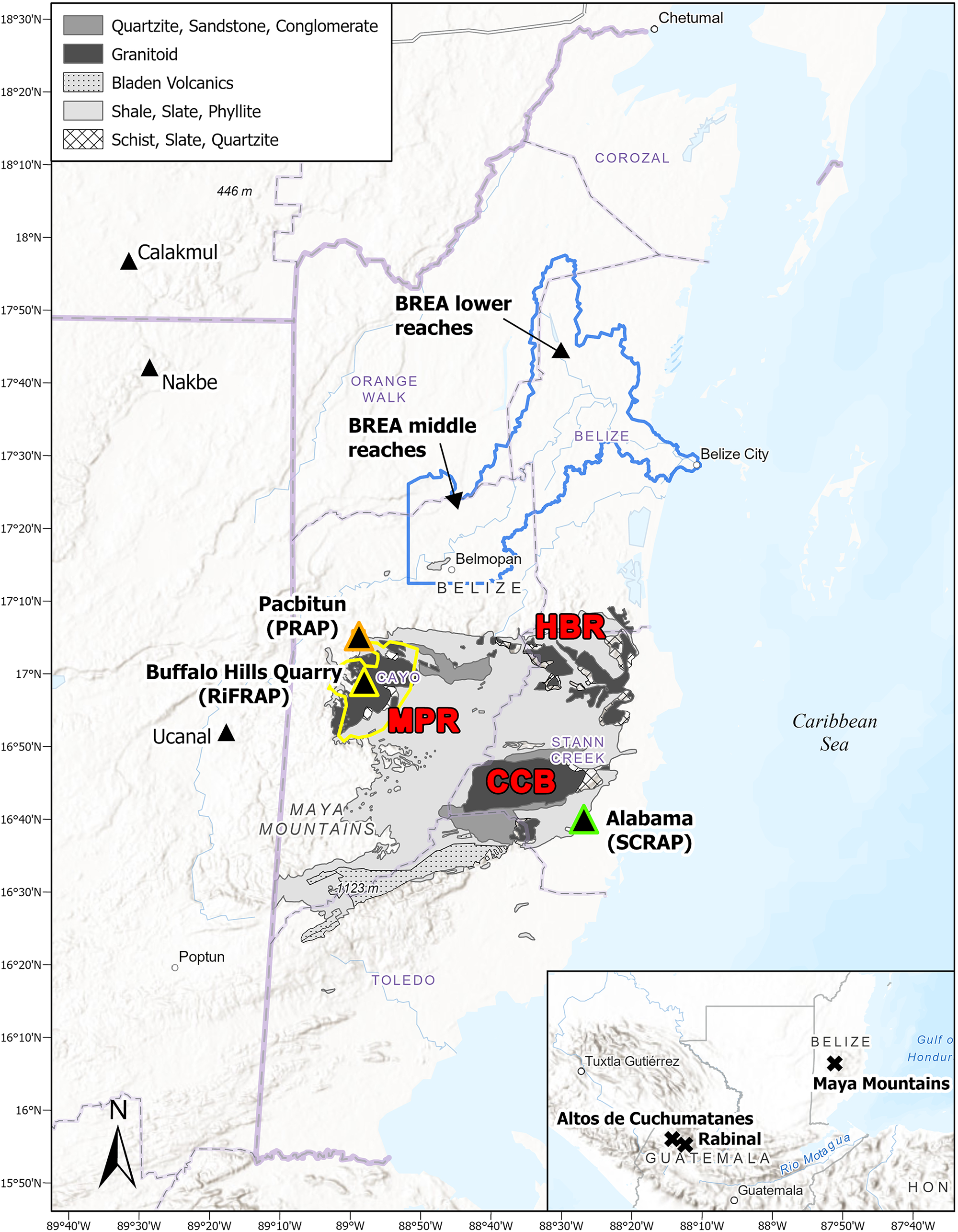
The Mountain Pine Ridge batholith, the namesake of the Mountain Pine Ridge Forest Reserve (hereafter, “the Reserve”), is one of just three granitic rock sources in the Maya Lowlands (Figure 1) (Weyl Reference Weyl and Borntraeger1980; see introductory article by Brouwer Burg et al. in this Compact Section). Though it has long been recognized as a primary source of vital resources for the ancient Maya, including granite (Graham Reference Graham1987), only two archaeological studies have been undertaken on the batholith. The earliest was an unsuccessful attempt to identify pre-agricultural deposits (Thompson Reference Thompson and Eric1938). The other documented a “unique Maya shrine site” consisting of a couple of platforms made from “rather irregular granite slabs laid in rough courses,” both associated with boulder formations (Bullard Reference Bullard1963:99). Although we have yet to relocate the site, the description is reminiscent of the quarry-workshop sites described in this article. That it includes a quarry-workshop area was confirmed by Tawny Tibbits (personal communication, Reference Tibbits, Peuramaki-Brown, Burg, Tibbits and Harrison-Buck2023) who had relocated it while conducting geochemical sourcing for a geoarchaeological study of GST recovered from sites throughout Belize (Tibbits Reference Tibbits2016). In particular, she recalled the presence of a similar artifact assemblage to those we describe here. The ritual function ascribed to the site remains unconfirmed (see Schneider in this Compact Section for common historical misattribution of quarries as ritual sites).

Figure 1. Map of the Eastern Maya Lowlands showing archaeological projects and sites mentioned in text. CCB = Cockscomb Basin, HBR = Hummingbird Ridge, MPR = Mountain Pine Ridge.
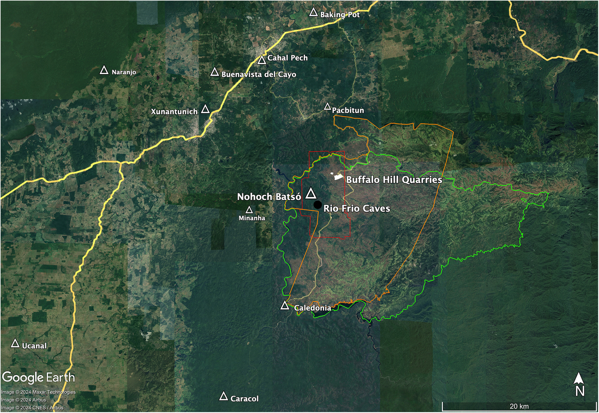
With a lack of previous survey data to draw on due to the erroneous belief that the Mountain Pine Ridge was largely devoid of ancient Maya sites, the archaeological potential of the Reserve was largely unknown at the onset of the RiFRAP. To date, the project has focused primarily on the Rio Frio caves (Mason Reference Mason1928; Spenard and Mirro Reference Spenard and Mirro2020) and the Nohoch Batsó site (Spenard et al. Reference Spenard, Mirro and Mai2023) in the west of the Reserve in an area underlain by limestone (Figure 2). RiFRAP’s survey of the Mountain Pine Ridge batholith has been limited to nonsystematic, opportunistic pedestrian survey along the Caracol Road. At the start of the 2022 field season, that work had resulted in the documentation of several low-density lithic (chert) scatters and isolated artifacts on deflated hilltops, and two small potential quarries along Granite Cairn Road (Mirro and Spenard Reference Mirro, Spenard and Spenard2020).

Figure 2. Regional map showing the Mountain Pine Ridge Forest Reserve (green polygon), RiFRAP permit concession area (orange polygon), area of LiDAR coverage (red polygon), RiFRAP sites, and a sample of ancient Maya settlements where granite GST have been reported. The light-yellow linear feature passing through the Mountain Pine Ridge is the Caracol Road.
Coauthor Mai had previously recognized Buffalo Hill Quarries as an ancient Maya site, and he brought project members to it while conducting opportunistic survey nearby in 2022. Surveying commenced that season, recording a dozen extraction loci, but a lack of time and thick vegetation covering its features prevented its full recordation. Acquisition of aerial LiDAR data for a geographically diverse portion of RiFRAP’s permit concession area that fortuitously included the entire site greatly aided survey efforts there (Spenard Reference Spenard and Spenard2023). Matching the previously mapped features of Buffalo Hill Quarries to the LiDAR data allowed us to identify its full extent (50 ha) as well as 14 additional sites spread over 11.5 km2 throughout the region. Twelve are composed of no more than four adjacent extraction pits surrounded by berms of debitage. The other two span 32 ha (∼80 acres) and 5 ha (∼12 acres) respectively. Ground truthing the LiDAR data in 2023 led to the discovery of Moshy’s Hill (7.5 ha). In total, the combined size of the quarry sites in the LiDAR-scanned area is approximately 100 ha or 1 km2, a testament to the landscape-scale extraction and GST-crafting industry centered there, yet their wide geographic distribution revealed in the data set suggests others remain unidentified in unscanned portions of the Reserve.
Site descriptions
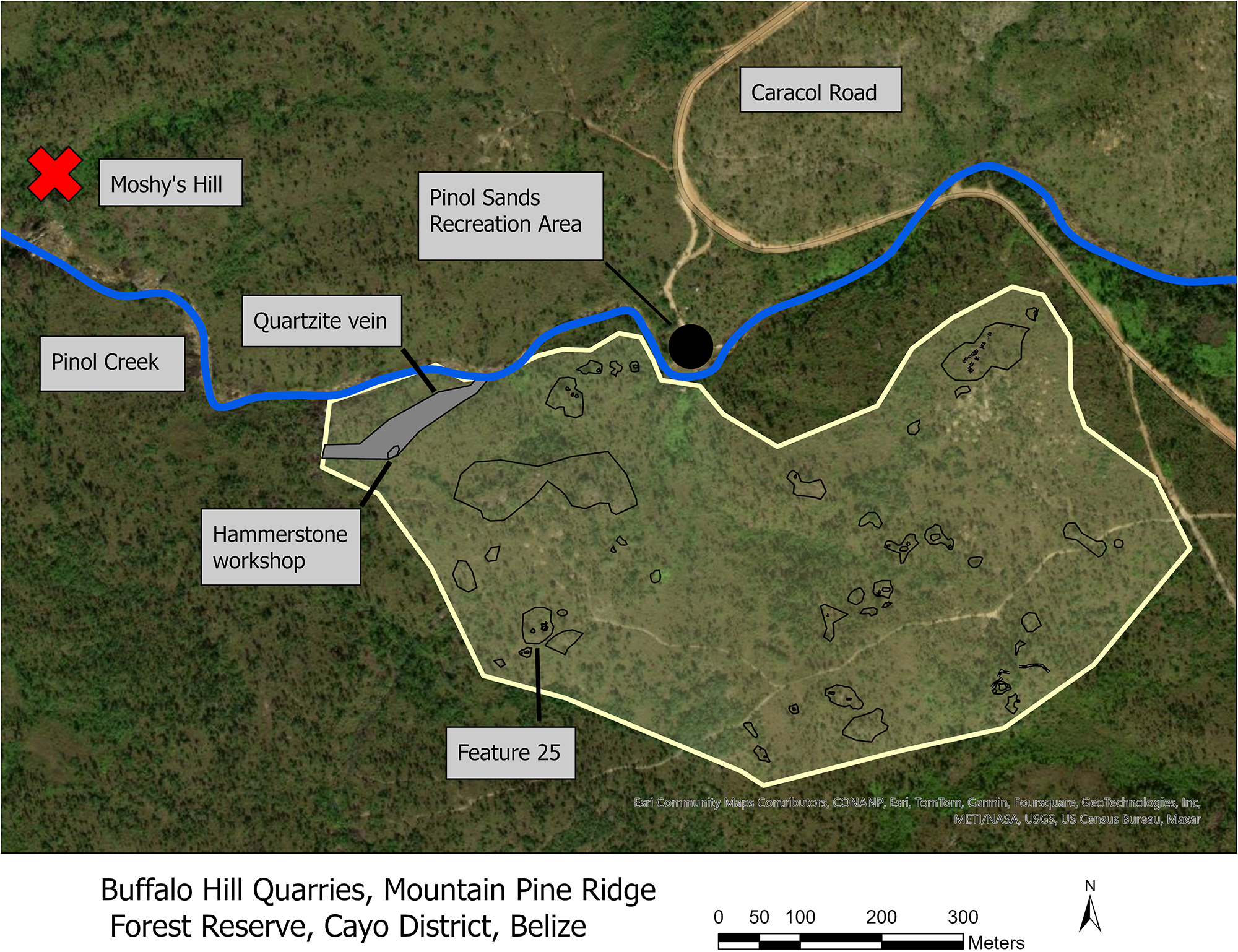
Buffalo Hill Quarries is the largest and most comprehensively studied of the Reserve extraction sites (Figure 3). It abuts Pinol Sands recreation area on an elevated ridge along the southern bank of Pinol Creek and is surrounded on its other three sides by an arroyo that drains into the larger waterway. The site covers an area of approximately 50 ha (about 123 acres) measuring 1 km east–west and 0.5 km north–south. We initially identified 27 distinct activity areas distributed across that span, although ground truthing efforts revealed that debitage piles frequently overlap and multiple extraction events occurred in the same pit, making it problematic to differentiate them. As such, we discontinued tallying activity areas and instead simply recorded the boundaries of debitage piles. As mapped, the total area of debitage piles in the site measures approximately 7.5 ha (18.5 acres). We undertook test excavations on two of the activity areas, Features 21 and 25, and data collected from them inform this report. That the quarries are the result of ancient Maya activity is confirmed by the regular presence of earthenware ceramics at the sites. Most are very badly eroded, but the few diagnostic pieces recovered (Belize group) are all known from elsewhere to date to the Late Classic period (a.d. 700–900).

Figure 3. Map of Buffalo Hill Quarries (shaded yellow polygon) and surrounding area. Hollow black polygons and black linear features within the Buffalo Hill Quarries polygon represent mapped extraction areas. The solid gray polygon in the same area is the mapped extent of the quartzite vein. Excavations were undertaken in the quarry pit marked “Feature 25.” Moshy’s Hill indicated by red “X.”
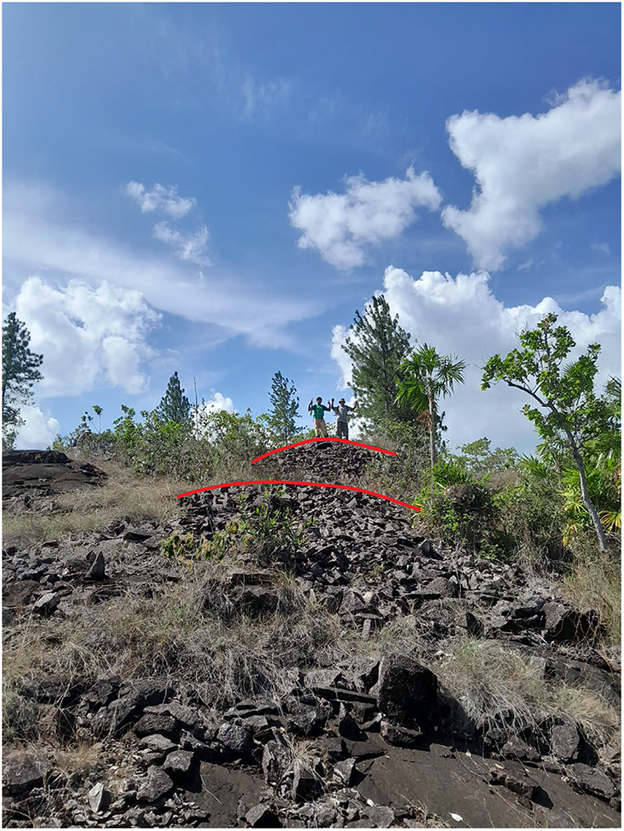
Overlooked in the initial review of the LiDAR data, Moshy’s Hill is on the north side of Pinol Creek approximately 0.5 km downstream from Buffalo Hill Quarries (Figure 4). It is much more compact than the latter, only extending over an area of approximately 7.5 ha (about 19 acres). The visited portion of the site consists of a series of massive debitage terraces beginning at the banks of Pinol Creek and continuing to the crest of the hill. Some are over 2 m tall and more than 8 m long. Few quarry pits are present; instead, raw-material extraction was largely achieved through strip mining and cutting faces. That they visualize the same as unmodified rock exposures in the LiDAR data, and the lack of quarry pits are the two paramount reasons the site was overlooked initially. Yet they are readily visible in aerial photographs, a lesson for future remote-sensing investigations. Though covering a much smaller area than Buffalo Hill Quarries, a visual comparison of debitage concentrations between the two sites indicates that the extraction and reduction activities were much more intensive at Moshy’s Hill.

Figure 4. Photograph looking uphill toward debitage terraces at Moshy’s Hill. Platform edges highlighted with red lines. Photograph by M. Flores, courtesy of the Rio Frio Regional Archaeological Project.
Extraction site types
Our investigations of Buffalo Hill Quarries and Moshy’s Hill have resulted in the identification of three common raw-material extraction site types: quarry pits, strip mines, and cut faces. Generally speaking, in all three cases, stone removal lacked efficiency and was largely dependent on the fortuitous fracturing of the bedrock, aided in part by natural jointing as elaborated below. The presence of reduction tools, preforms, and discards strewn around the extraction sites indicates some finishing also took place, but further studies are necessary to determine the full chain of operations that occurred at them.
Quarry pits are the most common type of extraction site at Buffalo Hill Quarries and in those identified in the LiDAR data. They are often ovoid- or “U-” shaped in form and measure anywhere from 5 to 30 m wide and up to 3 m deep, though most are between 1.5 and 2 m (Figure 5). They were usually made on gently sloping ridges near areas of exposed bedrock by digging through overlying matrix to expose underlying raw rock. Raw material was extracted in irregularly shaped blocks and slabs, facilitated, in part, by the use of expedient wedges made from beveled granitic blocks that were forced between natural joints in the bedrock (Figure 6). It is important to note that the jointing pattern in the bedrock is random and rarely tabular, and, as a result, much waste was created in the process. Unusable material was tossed to the edges of the extraction areas, in part, creating the berms of debitage around them (Figure 7). The floors of the quarry pits were largely free of debitage, indicating either that they were kept clean or that shaping and finishing activities happened elsewhere. The latter is more likely. Indeed, our excavations revealed pit-edge workshops as evidenced by large concentrations of conchoidal fractured granite flakes intermixed with the discarded, unworked slabs surrounding the holes.

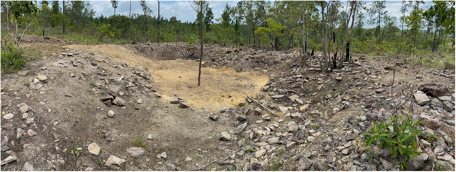
Figure 5. Panoramic overview of quarry pit cleared of vegetation (Buffalo Hill Quarries Feature 25). Photograph by J. Spenard, courtesy of the Rio Frio Regional Archaeological Project.

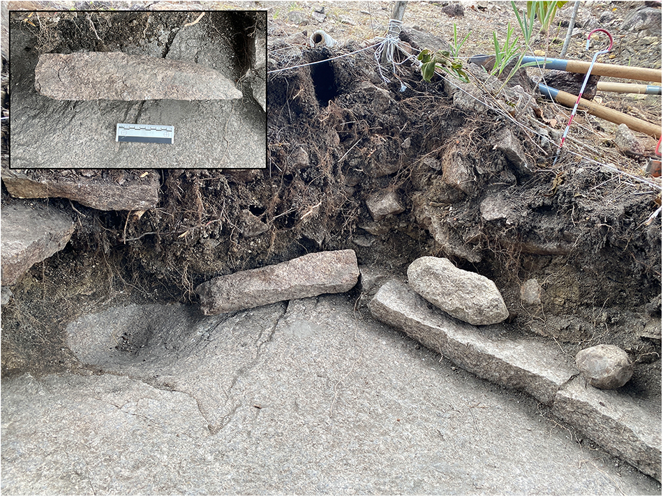
Figure 6. Detailed photograph of Buffalo Hill Quarries Feature 25 excavation showing, from left to right, a bedrock pit carved into the quarry floor, an expedient wedge, and a full-loaf mano preform and hammerstone on top of a natural bedding plane. Note the flake scar at the center point of the mano facing the unit wall. Inset photograph shows profile view of wedge. Photographs by J. Spenard, courtesy of the Rio Frio Regional Archaeological Project.

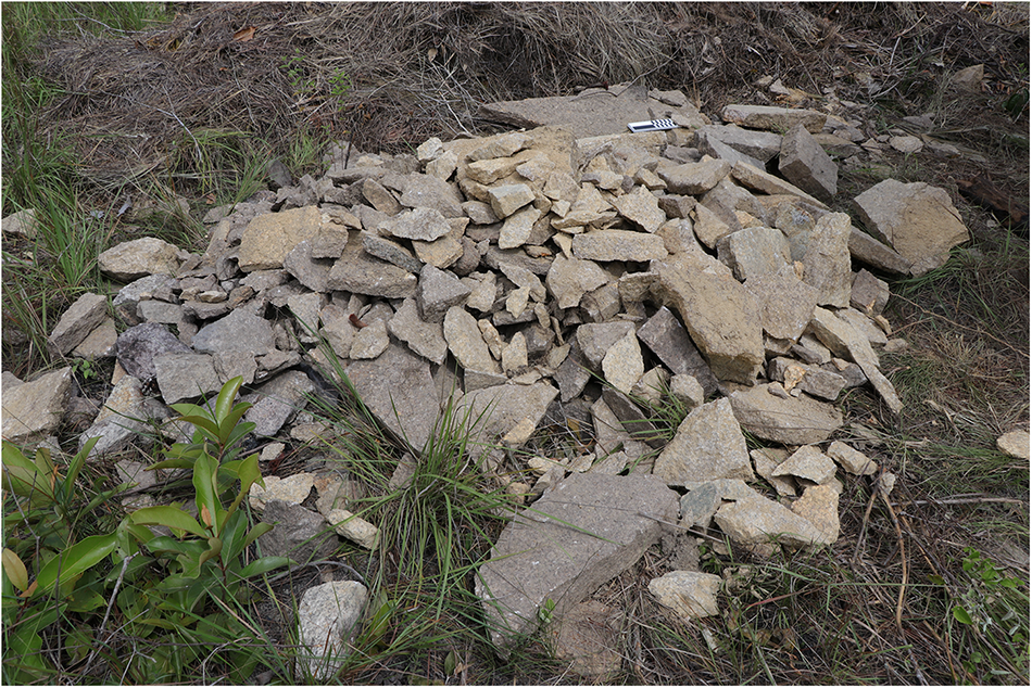
Figure 7. Photograph of debitage excavated from Buffalo Hill Quarries Feature 25 showing discarded granite slabs (quarry tailings) mixed with reduction debitage from GST production. Photograph by J. Spenard, courtesy of the Rio Frio Regional Archaeological Project.
Strip mines occur on low-profile exposures of bedrock with natural joints. Similar to quarry pits, wedges were used to pry blocks of workable material from the parent source. We distinguish strip mines from quarry pits because they are not excavated below the surface, although given their many other similarities, the two may be variations along a continuum rather than different raw-material removal strategies. The size of strip mines is nonuniform, their extent being determined by the quantity of exposed rock available and natural joints in it. Evidence for this method includes angular scars on low-profile exposures of bedrock, the result of removing natural bedded sheets of granite.
Cut faces consist of modified granite boulders and outcrops from which slabs of material were removed from exposed rock faces. They were noted at both Buffalo Hill Quarries and Moshy’s Hill and are evidenced by the presence of pecking and scarring on bedrock exposures. Though often much smaller than quarry pits, debitage, reduction tools, and discards are also commonly associated with such features.
Site features
Two classes of distinct features—bedrock pits and erected granite blocks—have been recorded at all three types of extraction sites. Their functions remain uncertain, but we interpret them as workshop components. Additional features are likely to be recognized as our investigations continue.
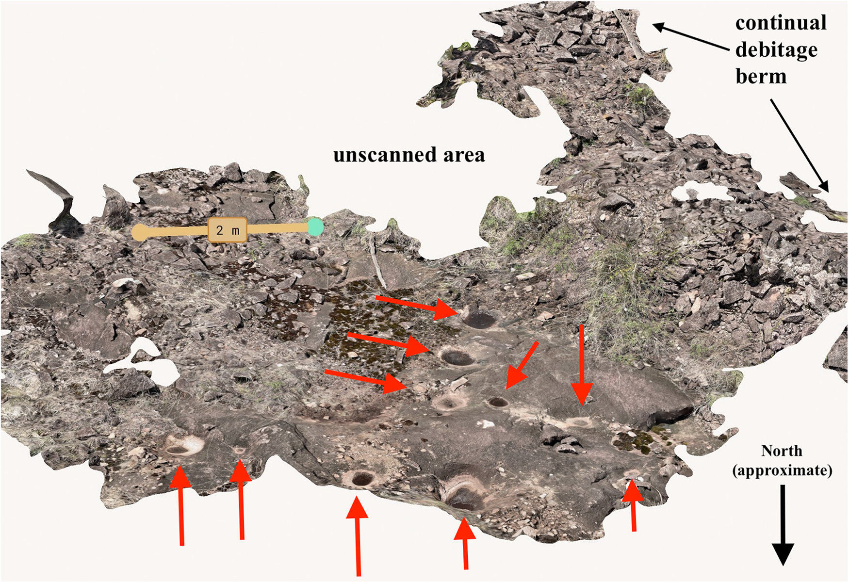
Bedrock pits are ovular-to-round features with slightly polished surfaces carved into bedrock and boulders. They are often at the foot of low-elevation rises, ideal locations for sitting down and working comfortably between one’s feet. Yet, one was uncovered in the flat floor of an excavated quarry pit at Buffalo Hill Quarries, indicating they were made in a variety of locations. Several dozen combined have been recorded at Buffalo Hill Quarries and Moshy’s Hill (Figure 8; see also Figure 6).

Figure 8. Oblique view screen shot from 3D model of the summit of Moshy’s Hill showing a dense concentration of bedrock pits (indicated by red arrows) adjacent to a debitage berm.
The pits were made by repetitive actions that we posit are related to mano finishing. In an ethnoarchaeological study of contemporary Guatemalan stone workers who made manos and metates with lithic technology, the researchers include a photograph of a hand stone being finished with a pecking tool at a home workshop (Hayden Reference Hayden and Hayden1987:Figure 2.21). The text reports that the mano is continually turned as it is pecked into its final shape. The accompanying photo shows a circular pocket being carved into the ground by the rotating action. Although the pictured tool was being made in sediment, we propose that the bedrock pits in the Reserve sites may have been formed by a similar process, a side effect of turning large quantities of manos and half-loaf pics—described below—as they were pecked into shape.
Erected granite blocks were noted at both Buffalo Hill Quarries and Moshy’s Hill. The blocks are rectangular in shape and measure about 50 cm on a side. Most are positioned in the ground in such a way that a corner edge is at or near the very top of the block. One such block was recorded on the floor of the Feature 25 quarry pit. Excavations were unable to determine its function although archaeological evidence from elsewhere suggests they may have been workstations. For example, at the Antelope Hill Quarries site in Arizona, “where blocks of stone were extracted and removed, level platforms were created and were used as workstations” (Schneider Reference Schneider1996:304–305). We posit that the erected blocks at the Mountain Pine Ridge quarry sites may have served similar functions.
Artifacts
While raw-material removal strategies vary across the sites, all extraction areas share similar artifact assemblages. Each is surrounded by berms of debitage intermixed with a variety of extraction and reduction tools (hammerstones and pics), as well as discarded manos and metates.
Debitage is a collective term that refers to quarry tailings and reduction waste. Although formal calculations remain to be completed, these two classes of artifact are clearly the most represented in the quarry-workshop assemblages by far. Combined, their total number at extraction sites easily numbers into the tens of thousands, if not much greater. In comparison, the total number of non-debitage artifacts recorded from an extraction pit that was completely cleared of vegetation totaled about 350 objects.
Hammerstones are ubiquitous in the Reserve sites. They are regularly mixed into the debitage piles surrounding extraction features or on the ground surface near the margins of activity areas (Figure 9a; also Figure 6). They are most often made of quartzite, although some are made of chert and granite. The likely raw-material source of Buffalo Hill Quarries’ quartzite hammerstones is a vein of the material on the northern boundary of the site that also appears to have been quarried—the ridge it formed is covered in flakes and an untested mound associated with it is presumed to be a hammerstone workshop (see Figure 3).

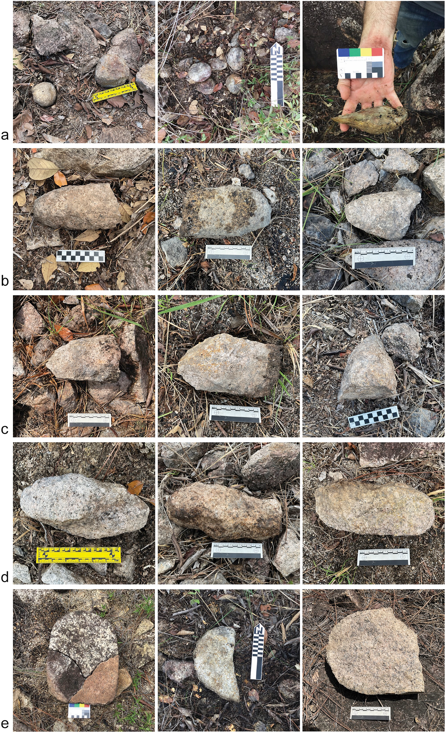
Figure 9. Photograph collage of common non-debitage artifacts (discards and preforms) from the Mountain Pine Ridge Quarries, including: a) hammerstones; b) half-loaves; c) half-loaf pics; d) full loaves; and e) metates. Photos courtesy of the Rio Frio Regional Archaeological Project.
Hammerstones are commonly spherical or disk shaped, but irregular forms occur. While a variety of sizes have been recorded, most are for single-hand use. The largest encountered is over 60 cm in diameter and over 30 kg in weight, likely used to extract raw material or during the earliest stages of reduction. In many instances the tools are found clustered together. Today, quarry workers cache their tools to keep them safe from one another and to avoid the extra weight of transporting them home (Hayden Reference Hayden and Hayden1987; Nelson Reference Nelson and Hayden1987:132, 144), both likely explanations for their regular occurrence in the Reserve’s quarries. Notably, many hammerstones were broken into flakes and possibly repurposed into other tools.
Half-loaves are conical objects, and the most common non-debitage granitic artifact type encountered across all sites (n=254) (Figure 9b). At the ancient Maya GST finishing workshops at Pacbitun (see King and Powis this Compact Section; Skaggs et al. Reference Skaggs, Micheletti, Lawrence, Cartagena, Terry, Powis, Skaggs and Micheletti2020; Ward Reference Ward2013), similar items are interpreted as mano preforms; however, their ubiquity and large numbers in the Reserve sites, as well as their relatively standardized measurements suggest they were intentionally created. Many of the ends are pointed and have some battering wear (Figure 9c). We propose that those that do may be analogous to basalt picks with knapped, pointed edges that are used by traditional highland Guatemalan stone workers to shape manos and metates from vesicular basal (Hayden Reference Hayden and Hayden1987; Hayden and Nelson Reference Hayden and Nelson1981; Nelson Reference Nelson and Hayden1987; Searcy Reference Searcy2011).
Full-loaf mano preforms (n=14) appear much less frequently than half-loaves (Figure 9d). All have slightly tapered ends, but their bodies are uniformly thick, further evidence that the half-loaves were intentionally produced. A single large flake scar at the mid-point on many of the objects recorded suggest a common step of the reduction process. At least some were shaped from blocks pried from areas of bedrock with adjacent parallel fractures.
Metates (n=10) are much less frequently encountered in the Reserve quarry sites than manos even though the two items are often paired together in their use contexts and ethnographic reports indicate they were created often in sets (Figure 9e) (Cook Reference Cook1982). Those we have confidently identified were either near end-stage reduction or were blocks that clearly exhibited pecking scars and evidence of shaping. Others in the earliest stages are difficult to identify, as granitic slabs that show no signs of working but that are similar in size are common in the quarry-workshop areas. Determining whether the unworked blocks are debitage, preforms, or products of natural fracturing requires more targeted studies.
Conclusions
Because our work on the Mountain Pine Ridge granite quarry workshops is only just beginning, and they are the first sites of their kind identified in Maya archaeology, we conclude with several questions to guide future related research. Firstly, who were the quarry workers? Were they a local community of full-time specialists, or did itinerant stone workers travel to the area from surrounding sites? Our LiDAR data reveal some domestic mounds nearby, but there are seemingly too few to have accommodated supplying the Classic period Eastern Lowlands. If the work was done by a local resident population, was the production and distribution centralized and managed by a local elite? At about 5.5 km distant, Nohoch Batsó was the closest Maya center to Buffalo Hill Quarries. What was the relationship between it and the quarry workshops? Was it a distribution hub, or a marketplace where they were traded? Moreover, how are the Reserve’s extraction sites related to the documented workshops at Pacbitun discussed by King and Powis in this Compact Section? Were communities affiliated with other sites bordering the Mountain Pine Ridge such as Barton Creek, Caledonia, Camp 6, Mahogany, Ramonal, and Tipan Chen Uitz, also working granite (Andres et al. Reference Andres, Wrobel and Morton2010; Awe et al. Reference Awe, Weinberg, Guerra and Schwanke2005; Chase et al. Reference Chase, Chase, Awe, Weishampel, Iannone, Moyes, Yaeger, Brown, Shrestha, Carter and Diaz2014; Moyes et al. Reference Moyes, Kosakowsky, Ray and Awe2017)? Were the GST made at the Reserve quarries and those made at Pacbitun serving the same distribution networks?
Did ritual play a role in the process? The nature of Bullard’s (Reference Bullard1963) “shrine” notwithstanding, Spenard (Reference Spenard2014) documented a ritual cave site about 3 km north of Buffalo Hill Quarries that held an unusually large quantity of granite GST and quartzite hammerstones compared to other caverns in the area. Was that and other caves in the region used for rituals to an Earth-Lord-like being who may have been considered the true owner of the rock being collected and worked (e.g. Schackt Reference Schackt1984)? Was Bullard’s (Reference Bullard1963) shrine actually a ritual structure, or did it serve some other purpose, perhaps as an administrative node? Are there others like it in the Reserve? Overall, what this study has revealed is that far from being a region devoid of ancient Maya sites, the Mountain Pine Ridge is a vast cultural landscape shaped by an ancient Maya granite GST industry that we are only just beginning to understand.
Data availability statement
The Belize Institute of Archaeology’s guidelines recommend against making LiDAR data sets available to help protect the country’s archaeological heritage from looting and other illicit activities. Other data used in this publication are housed at the California State University San Marcos Department of Anthropology and can be made available to researchers upon request to the corresponding author.
Acknowledgements
We would like to thank the Belize Institute of Archaeology and Belize Forest Department for permitting the Rio Frio Regional Archaeological Project’s investigations. We would also like to express our thanks to the volume co-editors, Drs. Marieka Brouwer- Berg Burg and Tawny Tibbits for their comments on earlier versions of this paper. Three anonymous reviewers provided valuable feedback that improved this manuscript.
Funding statement
Support for the investigations reported here was provided by an Archaeological Institute of the Americas-–National Endowment for the Humanities Post Fieldwork Grant and California State University San Marcos.
Competing interest
The authors declare none.