


Introduction: the scarcity of Iron Age cargoes related to harbours
Following the collapse of Late Bronze Age trading systems (c. 1200 BC), trade and connectivity in the eastern Mediterranean gradually recovered in the Iron Age (c. 1200–550 BC). Regional trading networks between Egypt, Cyprus and the Levant—already in place in the eleventh century BC—expanded to include central and western Mediterranean networks in the tenth–ninth centuries BC, which was followed by the expansion of the Phoenician economic and cultural sphere all the way to Iberia by the eighth century BC. By c. 650 BC, the Mediterranean trading system was extensively integrated, and included all coastal areas between Tyre and Dor to the east and Cádiz and Mogador on the Atlantic coasts of Europe and Africa, respectively, to the west (Broodbank Reference Broodbank2013: 445–505, fig. 10.2; López-Ruiz Reference López-Ruiz2021; Cline Reference Cline2024: 80–110). In the past 15 years, a growing body of evidence has shown that the coast of modern-day Israel played a role in Iron Age Mediterranean maritime connectivity and integration in the eleventh–seventh centuries BC. However, this evidence is mostly indirect, garnered primarily from the analysis of imported items found on land (Maeir Reference Maeir, Ben-Yosef and Jones2023), such as amphorae and other containers (Master Reference Master2003; Fantalkin Reference Fantalkin, Villing and Schlotzhauer2006; Ben-Dor Evian Reference Ben-Dor Evian2017; Waiman-Barak et al. Reference Waiman-Barak, Gilboa, Yasur-Landau and Arie2018), silver items (Eshel et al. Reference Eshel, Erel, Yahalom-Mack, Tirosh and Gilboa2019), foodstuffs (Ventura-Sisma et al. Reference Ventura-Sisma2018), spices (Gilboa & Namdar Reference Gilboa and Namdar2015) and mobilised livestock (Harding & Marom Reference Harding and Marom2022). At the same time, the study of Iron Age harbours has developed considerably; underwater excavations have revealed formal eleventh–seventh-centuries BC harbours with built quays, moles (stone structures similar to a pier or causeway) and sea walls at Dor and Atlit, while underwater surveys in the Carmel Coast have demonstrated the existence of opportunistic anchorages alongside formal harbours (Haggi & Artzy Reference Haggi and Artzy2007; Haggi Reference Haggi2009; Arkin Shalev et al. Reference Arkin Shalev, Gambash and A.2019a, Reference Arkin Shalev, Gilboa and Yasur-Landau2019b, Reference Arkin Shalev, Galili, Waiman-Barak and Yasur-Landau2021; Yasur-Landau Reference Yasur-Landau, Yasur-Landau, Cline and Rowan2019a), and geoarchaeological studies at Dor and Akko are contributing to the understanding of harbour locations and use periods (Giaime et al. Reference Giaime, Marriner and Morhange2019; Shtienberg et al. Reference Shtienberg2021, 2022; Marriner et al. Reference Marriner, Morhange, Flaux, Carayon, Kaniewski, Gilbert, Goldberg, Holliday, Mandel and Aldeias2023).
To date, however, no Iron Age ships or cargoes have been identified near any port site on the coast of the southern Levant, hindering the study of contemporaneous maritime connectivity and its related aspects of adaptation and resilience (Yasur-Landau Reference Yasur-Landau, Yasur-Landau, Cline and Rowan2019a). Furthermore, in the entire Mediterranean region we currently know of only around 11 boats and cargoes dating to this 400-year span of Mediterranean integration, highlighting a significant lacuna in our understanding of maritime trade (Table 1). The aim of our research is therefore to gain insights on the longue durée of maritime trade through the still-underexplored lens of ship cargoes, focusing on those found underwater in the context of the Iron Age port town of Dor on the Carmel Coast in northern Israel (Arkin Shalev et al. Reference Arkin Shalev, Gambash and A.2019a, Reference Arkin Shalev, Gilboa and Yasur-Landau2019b). In particular, our research explores the zones of interaction—that is, the areas from which the cargoes originate (Greene Reference Greene, Leidwanger and Knappett2018: 138)—as they are reflected in the Dor cargoes, and the impact of political changes on patterns of trade at Dor. During 2023 and 2024, we located and commenced excavation of three submerged Iron Age cargoes in the Dor Lagoon (also known as the Tantura Lagoon), the southernmost anchorages at Dor (Figure 1). These are the first Iron Age cargoes found in an anchorage and port city in Israel. To date, we have excavated only up to 25 per cent of the sandbar in which the cargoes are located, and excavations are ongoing.
Table 1. Examples of Iron Age Shipwrecks and Cargoes in the Mediterranean.


Figure 1. a & b) Maps showing the location of Dor/Tantura Lagoon; c) the position of the Dor L and M wrecks and Iron Age harbour remains in Dor’s South Bay (figure by Marko Runjajić).
Dor Lagoon and methods in the 2023–2024 excavations
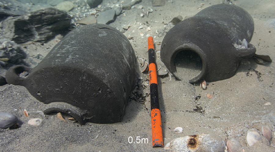
The Dor Lagoon is protected from the west by three islets, providing safe anchorage (Figure 1). Sediments preserve an exceptional record of at least 26 ships and cargoes, as well as approximately 60 stone anchors discovered in excavations and surveys (see Wachsman & Raveh Reference Wachsmann and Raveh1984; Kingsley & Raveh Reference Kingsley and Raveh1996). Previous excavations, conducted by the University of Haifa in collaboration with Texas A&M University (e.g. Wachsman & Kahanov Reference Wachsman and Kahanov1997), focused on shipbuilding techniques in post-Roman periods (after c. 250 AD) (Kahanov Reference Kahanov, Ford, Hamilton and Catsambis2012). The 2023–2024 excavations of the University of Haifa and University of California, San Diego, were codirected by Assaf Yasur-Landau and Thomas E. Levy, with Marko Runjajić as field director. They focused on a sandbar located approximately 80m west of the coast and 50m from the sunken rocky reef connecting the Tafat and Dor islets. Two cargoes were reported in this area in previous surveys: Dor M (Wreck 13), which yielded two intact and one partial storage jars, and was initially dated to the fourteenth–thirteenth centuries BC; and Dor L (Wreck 12), initially dated to the fifth–fourth centuries BC (Kingsley & Raveh Reference Kingsley and Raveh1996: 57–59). The surface of the latter cargo was partially exposed by the Haifa/Texas A&M excavations, uncovering a wood-and-lead anchor stock and pottery, left in situ in 1995 (Wachsman & Kahanov Reference Wachsman and Kahanov1997: 11–13). In 2023, an area of approximately 10 × 6m was excavated using a water dredge system; in 2024, a further 9 × 4m area was excavated. All finds were assigned a locus and basket (Figures 1, 2 & 3), and their exact position was established using GPS-aligned 3D models. The area was covered by a 1.5m-thick layer of coarse yellow sand with Byzantine and Late Islamic pottery inclusions, most likely deposited during and after the 1994–1995 fieldwork. An in situ archaeological deposit lay below the sand layer; this consisted of dark-grey sand that became increasingly siltier in lower elevations and contained almost exclusively Iron Age finds. The excavation reached a bottom level of 1.9–2.4m below sea level (bsl). The latest and best-preserved cargo deposit, labelled L2, disturbed earlier deposits. All finds reported here originate from the top 0.3m of the deposit, which contains numerous additional artefacts that are awaiting future excavations.
Dor L2
Dor L was initially identified as a Persian-period (c. 540–330 BC) cargo, due to the presence of basket-handle amphorae (Kingsley & Raveh Reference Kingsley and Raveh1996: 58–59); however, our excavations demonstrate the presence of two sets of chronologically distinct cargoes that partially overlap. The later cargo, Dor L2, is more intact and contained basket-handle amphorae and iron blooms from the seventh–sixth centuries BC, mainly in loci (L) 23.004, 23.006 and 24.019 (Figure 2). The cargo in L23.004 and L23.007 was mixed with an earlier, early eighth-century BC cargo (L1) containing Phoenician-style storage jars. Work began by re-exposing the wood-and-lead anchor stock discovered in the 1995 survey (Figures 2 & 3). Its preserved dimensions are 2.05 × 0.16 × 0.085m (some 0.15m length missing), and it has four chambers filled with lead. A radiocarbon date obtained from a sample of the anchor wood lies within the Hallstatt plateau (see Rose et al. Reference Rose, Müller-Scheeßel, Meadows and Hamann2022) yet with higher probabilities for dates within the Iron Age (i.e. before c. 550 BC; see online supplementary material (OSM): sample 1). Iron Age anchors with both wood and lead components are rare but attested in the archaeological record; a similar but smaller anchor was found at the Mazarrón 2 shipwreck, dated to the late seventh or early sixth century BC (see Table 1; Negueruela Reference Negueruela, Aruz, Graff and Rakic2014; Kocabaş et al. Reference Kocabaş, Akkemik and Asal2024). The broken remains of at least 15 basket-handle amphorae and five Phoenician-style storage jars were recovered from L23.004, L23.006, L23.007 and L24.019. Basket-handle amphorae of Cypriot or southern Aegean origin first appeared in the eighth century BC, becoming more common in the late seventh century BC and into the Persian period (Kleiman et al. Reference Kleiman, Waiman-Barak, Finkelstein, Shai, Chadwick, Hitchcock, Dagan, McKinny and Uziel2018; Lehmann et al. Reference Lehmann, Shalvi, Shochat, Waiman-Barak and Gilboa2022). Resin from the interior of these amphorae provides similar radiocarbon dates (see OSM: samples 6 & 7). L23.006 and the adjacent L24.019 yielded the most coherent concentration of finds related to the L2 cargo (Figure 4), including basket-handle amphora sherds mixed with nine iron blooms. The blooms—an unusual find in a ship cargo pre-dating the third century BC (Schwab et al. Reference Schwab, Brauns, Fasnacht, Womer Katzev, Lockhoff and Wylde Swiny2022)—are sub-cubic to oval, weigh 5.10–10.45kg each and range in size from 150 × 95 × 110mm to 210 × 150 × 100mm, including the concretion and slag cover. One of the blooms (Bloom 3) was opened for sampling, revealing an uncorroded core (Figure 5a). A deciduous oak twig within the bloom provides a date range consistent with the anchor and amphorae (see OSM: sample 5). Other finds include at least 20 large stones—some volcanic stones and some green and red sedimentary rocks containing quartz veins—that do not originate from the coast of Israel and were likely part of the ballast from the boat carrying L2 (Figure 4).

Figure 2. Plan of remains found in the 2023–2024 excavations. IA: Iron Age (figure by Marko Runjajić).

Figure 3. a & b) 3D model of the composite anchor stock in situ; c) a schematic reconstruction of the anchor (figure by Marko Runjajić).

Figure 4. L23.006: a) the unexcavated deposit designated L2 with Cypriot basket-handle amphorae, iron blooms and ballast stones (b) overlying Phoenician amphorae from the earlier L1 deposit; c) a plan of the excavated area in 2023 (figure by Marko Runjajić).

Figure 5. Finds from L23.006: a) iron blooms; b) basket-handle amphora base containing resin; c) basket-handle amphora handles; d) a basket-handle amphora base containing grape seeds from L23.007 (figure by Marko Runjajić & Jonathan Gottlieb).
Additional lower halves of basket-handle amphorae contained organic finds, but these cannot be safely assigned to either L2 or L1 due to their location. The lower part of basket-handle Amphora 4 from L23.007 contained grape seeds (Figure 5d) that provide a date range similar to the L2 anchor (see OSM: samples 3 & 4). Half of another such amphora, from L23.006, contained date pits, providing a very narrow chronological range in the early eighth century BC, like that ascribed to L1 (see below and OSM: sample 2). These amphorae were therefore either scattered from the L2 and L1 cargoes or indicate the continuous use of this anchorage during the Iron Age.
Dor L1
Dor L1 represents a scattered cargo dating to late ninth–early eighth centuries BC, located mainly in the central and western part of L23.007 (Figure 6). An engraved single-hole stone anchor from this locus may belong to this cargo (Figure 6c), which also includes three complete and at least 10 partial Phoenician-style storage jars. These belong to an early and rare variant of Type TJ2 (Figure 2; Lehmann et al. Reference Lehmann, Shalvi, Shochat, Waiman-Barak and Gilboa2022: figs. 5, 11), with a thickened knob on the base, dating possibly to the late ninth–eighth centuries BC (Mazar Reference Mazar2009: fig. 33.2; Lehmann et al. Reference Lehmann, Shalvi, Shochat, Waiman-Barak and Gilboa2022: 79). A radiocarbon date from a grape seed in Amphora 1 (see OSM: sample 8) provides a short date range of 810–775 cal BC (at 95.4% confidence). Additional finds from the same context include parts of at least four thin-walled, well-burnished shallow bowls with red and black decoration and a cup or lid (Figure 7). These are typical of ninth–eighth-centuries BC Iron IIB contexts (Lehmann Reference Lehmann and Gitin2015: 117–18). Two of the bowls have mending holes, indicating that they were not goods for trade but rather well-worn pieces used by the boat’s crew. L23.006 and L24.019 include additional examples of the same amphorae, found to the east of the basket-handle amphorae of the Dor L2 cargo. This likely indicates that the Dor L2 cargo disturbed the earlier L1 cargo.

Figure 6. Cargo from Dor L1. L23.007: a) plan; b) in situ storage jars; c) stone anchor in L24.023: d) storage jar (figure by Marko Runjajić).

Figure 7. Pottery from L23.007: a) local amphorae; b) thin-walled bowls with red band and cup(?) (figure by Marko Runjajić & Jonathan Gottlieb).
Hence, the Dor L2 and L1 cargoes likely date to Iron IIC (seventh–sixth centuries BC) and IIB (late ninth–early eighth centuries BC), respectively, rather than to the initially proposed date of the fifth–fourth centuries BC. We interpret these finds as boat cargoes in different stages of preservation rather than an accumulation on the harbour floor for two reasons: 1) the presence of complete and restorable vessels indicates a primary deposit; and 2) ship gear and parts—namely the wood-and-lead anchor stock, stone anchor and ballast stones—are associated with the pottery. It is possible, based on wood preservation, that parts of the hull of L2 await excavation. More storage jars, as well as more sherds adjoining those recovered already, are also expected to be found, as only the top of the deposit was excavated.
Dor M and Iron I remains
The earliest partial cargo in the lagoon, Dor M, was identified by two complete and two fragmentary storage jars found during the 1980s surveys and initially attributed to the Late Bronze Age (Figure 8; Kingsley & Raveh Reference Kingsley and Raveh1996: 57–58). However, these are a rare type of Iron I storage jar, Pedrazzi Type 5.2, found at Tel Dor, Palaepaphos-Skales in Cyprus, Sarepta in Lebanon and Tanis in Egypt (Pedrazzi Reference Pedrazzi2007: 72–73; Gilboa et al. Reference Gilboa, Sharon, Boaretto and Sagona2008: figs. 9, 13; Knapp & Demesticha Reference Knapp and Demesticha2017: 111–12). The possible origin of this cargo was revealed with the exposure of a 6 × 2m ballast pile in L24.013, immediately to the east of L23.007, during the 2024 excavation (Figure 9).

Figure 8. a–c) Eleventh-century BC pottery from L23.007; d) identical pottery from the 1980s survey; e) multispectral imaging reveals red dipinti on pottery, possibly forming a numeral in the Hieratic script (multispectral imaging by Shai Halevi; figure by Marko Runjajić & Jonathan Gottlieb).

Figure 9. a) Plan of the eastern part of L23.007 and L24.013 showing Iron I finds; b) model of stone anchor and related ballast pile from L24.013; and c) detail of the Cypro-Minoan sign on the anchor (figure by Marko Runjajić & Assaf Yasur-Landau).
A one-hole stone anchor located to the north of this area bears an incision underneath the anchor hole, which appears to be a Cypro-Minoan script sign, CM 102 Variant 7 (Figure 9c; Polig & Donnelly Reference Polig and Donnelly2022: 52, fig. 5). The sign CM 102 is found incised on another anchor also found off the Carmel Coast, at Kfar Samir South (Galili & Rosen Reference Galili and Rosen2015: 74–75). The lower half of an Iron I storage jar, identical to the above-mentioned ones, was found upright and in situ to the north of the anchor, and a complete Iron I storage jar was found 1.5m west of the anchor. Multispectral imaging demonstrates that this latter jar bears red dipinto (a painting), perhaps describing a numeral in the Hieratic script. The eastern part of L23.007 contained three additional fragmentary Iron I storage jars, in a pottery deposit that originated in L1. One of these bears another dipinto, in black, of four or five possible linear script signs, perhaps Cypro-Minoan or Cypro-syllabic. The concentration of this rare type of Iron I storage jar in one area, as well as the associated ballast and anchor, increases the likelihood that they all belong to a single twelfth–eleventh-centuries BC cargo, albeit now scattered, additional parts of which are likely to be uncovered in future seasons (Figure 9).
Discussion: the new Dor/Tantura Lagoon cargoes in historical context
During the eleventh century BC, to which the cargo of Dor M is assigned, Dor established new trade with Egypt and Cyprus, becoming the dominant power on the Carmel Coast and perhaps beyond it (Gilboa 2021). Trade with Egypt is reflected in the numerous Egyptian vessels—amphorae and others found in land excavation at Tel Dor (Waiman-Barak et al. Reference Waiman-Barak, Gilboa and Goren2014). The port of Dor, the maritime prowess of its Sikel inhabitants and its location and role as a hub on the trade route from Egypt to the Phoenician heartland are all mentioned or reflected in the eleventh-century BC Report of Wenamun, a maritime adventure spanning Egypt, Dor, Phoenicia and Cyprus (Gilboa Reference Gilboa2015; Yasur-Landau Reference Borgna, Laffineur, Caloi and Carinci2019b). The wealth of Dor, gained through its maritime connections, was invested in the construction of monumental structures in Area D of the South Bay (Sharon & Gilboa Reference Sharon, Gilboa, Killebrew and Lehmann2013). Coastal geoarchaeological studies and underwater excavations between 2016 and 2024 have uncovered the remains of a massive coastal Iron IB fortification, built partially of large trapezoidal ashlar blocks, as well as an Iron I–II artificial mole to the south of the wall, used for unloading goods (Figure 1b). Both wall and mole are now submerged due to a rise in sea level (Arkin Shalev et al. Reference Arkin Shalev, Gilboa and Yasur-Landau2019b; Yasur-Landau et al. Reference Yasur-Landau2021; Shtienberg et al. 2022: fig. 9; Shahack-Gross et al. Reference Shahack-Gross2023).
Dor L1, likely a part of a scattered cargo of multiple, uniform storage jars, dates to Iron IIB, the late ninth and early eighth centuries BC. During this period, Dor was controlled by the Kingdom of Israel. Land excavations at Dor reveal signs of decline during Iron IIB, which were manifest in a halt in the construction of monumental architecture, as well as a sharp decline in imports from Egypt and Cyprus (Gilboa & Sharon Reference Gilboa, Sharon, Macginnis, Wicke, Greenfield and Stone2016). Still, the assemblage of Dor L1, with its Phoenician-style storage jars, is unequivocal evidence for the continuation of maritime activity during the Israelite rule in Dor in the ninth–eighth centuries BC.
Dor L2, dating to Iron IIC (c. 700–530 BC), represents trade in Dor’s harbour during the age of the empires. Dor fell under Assyrian rule after 733 BC and was likely transferred to Babylonian control following the demise of the Assyrian Empire, after 605 BC (Stern Reference Stern1994: 138). Given the radiocarbon ranges from the anchor and amphora residues, it is less likely that Dor L2 belongs to the very beginning of the Persian period, c. 525 BC (Stern Reference Stern1994: 149; Elayi Reference Elayi2006). During the Assyrian rule in the late eighth and seventh centuries BC, Dor regained its former prosperity and status as a trading city. This was part of a deliberate attempt by the Assyrians to regulate the administration of Dor and its relationship with maritime polities, reflected in Sargon II’s regulation of trade with Egypt in the eighth century BC (Thareani Reference Thareani2016) and in the seventh-century BC vassal treaty between Esarhaddon, king of Assyria, and Baal, king of Tyre. This treaty specifically mentioned Dor as one of the ports given to Baal (Na‘aman Reference Na‘aman1994: 3; 2009: 98–99; Yasur-Landau Reference Yasur-Landau, Yasur-Landau, Cline and Rowan2019a: 561–63). Following the Assyrian concession, the city was fortified and apparently settled by a new population (Gilboa & Sharon Reference Gilboa, Sharon, Macginnis, Wicke, Greenfield and Stone2016: 249). The attention given to Dor’s seafront during this period is attested by the addition of a new sea-gate with Assyrian-style constructional elements, which was also explored by our expedition (Figure 1; Arkin Shalev et al. Reference Arkin Shalev, Gilboa and Yasur-Landau2019b: 448–50, Reference Arkin Shalev, Galili, Waiman-Barak and Yasur-Landau2021: 146–47). In addition, pottery finds from the North Bay of Dor indicate some maritime activity in Iron IIC, perhaps using the bay as an opportunistic, nonformal anchorage (Arkin Shalev et al. Reference Arkin Shalev, Gambash and A.2019a). Dor L2 may be associated, therefore, with activities in the age of Assyrian or Babylonian imperial domain, when the port of Dor was operated within the trade concession given by the heads of the empires to client rulers from the Phoenician heartland. Ongoing studies of this cargo, which seems to include mostly items from outside the immediate Levantine coastal network, will establish its exact interaction zone.
Conclusions
Data from three Dor Lagoon cargoes provide insights into zones of interaction and the impact of political change on patterns of trade at Dor. Dor M, a scattered cargo, provides evidence of maritime trade in a period of both local and regional rapid recovery. Scripts on the anchor and storage jars found in Dor M suggest connections to Cyprus and Egypt, and the typology of the storage jars provides a link to the Phoenician coast. Together these correlate to the interaction zone of the city-state of Dor, identified through archaeological finds from the tell and through narratives from the Report of Wenamun. Dor L1, dated to the late ninth–early eighth centuries BC, with its uniform cargo containing coastal-type storage jars and galley wares of thin-walled bowls, may suggest a more restricted interaction zone that did not include Egypt and Cyprus—potentially paralleling the sharp decline of imports found on the tell in this period and according with the assumedly weaker maritime connections of the Israelite kingdom compared to those of the Phoenician polities (Gilboa & Sharon Reference Gilboa, Sharon, Macginnis, Wicke, Greenfield and Stone2016). Finally, Dor L2, belonging to the late seventh or early sixth century BC, with its cargo of basket-handle amphorae and iron blooms, likely reflects a wider phenomenon of basket-handle amphorae cargoes seen also in contemporaneous shipwrecks along the Anatolian coast at Kekova Adası, Kepçe Burnu and Çaycağız Koyu (Greene Reference Greene, Leidwanger and Knappett2018), indicating again an expanded interaction zone. This date corresponds with the heightened connectivity of Dor after its return to Phoenician hands, operating under the Assyrian and possibly Babylonian Empires.
Acknowledgements
We thank the Leon Recanati Institute for Maritime Studies Maritime Workshop, led by Amir Yurman and Moshe Bachar, without whom this excavation could not have succeeded. Tufik Bariah provided boating services.
Funding statement
This research was funded by a grant from the Malcolm H. Wiener Foundation, for the study of the Bronze Age in the Coast of the Carmel, and the Koret Foundation (grant no. 19-0295), aimed to support marine archaeology in the University of California, San Diego, and the University of Haifa.
Online supplementary material (OSM)
To view supplementary material for this article, please visit https://doi.org/10.15184/aqy.2025.71 and select the supplementary materials tab.


 Open access