Recent investigations of shell mounds associated with hunter-gatherer-fishers are generating new interpretations and considerable debate. Questions about function and meaning of mounds, intentionality of their construction, and their symbolism are shifting discussions from viewing shell mounds in ecological terms of subsistence, resource exploitation, and seasonality to considering them as significant structures on the landscape that serve as places for daily practices and rituals that are inextricably tied to social memory (Thompson Reference Thompson, Thomas and Sangar2010). Human memory is socially constituted, where mythical principles are mapped as reminders of catastrophes and triumphs in the past (Knapp and Ashmore Reference Knapp, Ashmore, Ashmore and Bernard Knapp1999:13), as an enduring record of past lives (Ingold Reference Ingold1993:152–153). Through memory of place and the reuse and reinterpretation of it, landscape is connected to the identity of its inhabitants (Gamble and Wilken Reference Gamble and Wilken2008). Landscape as identity is related to collective recognition of places, often associated with symbolic or ceremonial practices. Social memories are shaped by cumulative economic, social, and political factors (Climo and Cattell Reference Climo and Cattell2002) that are closely tied to the landscape. These places have the capacity to trigger self-reflection and memories of past times, people, and events (Basso Reference Basso, Feld and Basso1996). They may be repeatedly visited, modified, and interpreted, often reinforcing social relationships (Pauketat Reference Pauketat, Barbara and Walker2008) and creating links to the past and the ancestors (Meskell Reference Meskell, Van Dyke and Alcock2003, Reference Meskell and Yoffee2007; Yoffee Reference Yoffee and Yoffee2007). Memory of the past is preserved in these links, negotiated, reinterpreted, and commemorated in rituals and public events, some associated with the deceased, others with more quotidian activities; practices of remembrance emerge from repeated actions and performances (Meskell Reference Meskell and Yoffee2007:224).
Mounds as Places of Persistence and Social Memory
The materialization of social memory, whether through mortuary ceremonies, ritual congregations, or daily practices (Bourdieu Reference Bourdieu1977), provides the archaeologist with the possibility of identifying remembrance. This is not straightforward, especially for those who work in more ephermal sites associated with hunter-gatherers. Closely linked to ideas of social memory and landscape is the concept of place-making (Basso Reference Basso, Feld and Basso1996) and “persistent places,” locales that were used and occupied repeatedly over long periods of time (Kidder and Sherwood Reference Kidder and Sherwood2016; Schneider Reference Schneider2015; Thompson Reference Thompson, Thomas and Sangar2010; Thompson and Pluckhahn Reference Thompson and Pluckhahn2010).
Herein I present a case study from a shell mound at the far western end of Santa Cruz Island in southern California. I propose that multiple lines of evidence support the idea that El Montón (CA-SCRI-333) was a persistent place that over thousands of years of occupation became a prominent feature on the landscape, as the site became higher and expanded as people practiced rituals, staged feasts, buried their dead, and constructed houses. Before examining in detail, I first turn to discussions of shell mounds outside of southern California as theoretical and contextual background.
Southeastern United States
Several recent publications on hunter-gatherer shell mounds as places of social memory—as socially constructed monuments or landscapes, not just accumulations of refuse—are centered on sites in the southeastern United States (Kidder Reference Kidder, Sassaman and Holly2011; Marquardt Reference Marquardt2010; Randall Reference Randall, Sassaman and Holly2011; Russo Reference Russo1994; Sassaman and Randall Reference Sassaman, Randall, Burger and Rosenswig2012). Many interpretations rely on detailed construction histories of mounds that include geophysical surveys such as ground-penetrating radar (GPR) (e.g., Thompson and Andrus Reference Thompson, Fred and Andrus2011; Thompson and Pluckhahn Reference Thompson and Pluckhahn2010). Some investigate how mounds were tied to ritual behavior associated with feasting and mortuary ceremonialism, while others consider orientation and siting (Randall Reference Randall, Sassaman and Holly2011; Sassaman and Randall Reference Sassaman, Randall, Burger and Rosenswig2012). The earliest mounds in the southeastern United States are particularly relevant to this discussion because of their similarities to El Montón. One of the most prominent Archaic sites in the southeast, Watson Brake, consists of 11 earthen mounds elliptically arranged into a 280 × 370 m complex (Saunders et al. Reference Saunders, Mandel, Garth Sampson, Allen, Allen, Bush, Feathers, Gremillion, Hallmark, Edwin Jackson, Johnson, Jones, Saucier, Stringer and Vidrine2005). It is one of several Archaic mound complexes in the lower Mississippi River valley that date to 5,600–5,000 years ago and required planning, perhaps a reflection that non-egalitarian structures existed in the Archaic (Sassaman Reference Sassaman, Robert and Mrozowski2010).
Other World Regions
In the Torres Straits Islands, ceremonial mounds of dugong bones are documented, as well as mounds of large gastropods that were often used in rituals (David and Badugal Reference David and Badulgal2006; McNiven Reference McNiven2012). Earth and shell mounds in Australia and New Zealand number in the hundreds and have been interpreted primarily in economic terms and as significant boundary markers that denote ownership (Bailey and Flemming Reference Bailey and Flemming2008; Brockwell Reference Brockwell2006; Cribb Reference Cribb1991). Hausmann and Meredith-Williams (Reference Hausmann and Meredith-Williams2016) investigate middens in Saudi Arabia to explore accumulation rates of shell deposits. In Brazil, some are huge (up to 50 m in height), serve funerary purposes, and are prominent landscape features (Gaspar et al. Reference Gaspar, DeBlasis, Fish, Fish, Silverman and Isbell2008). Many hunter-gatherer mounds, including some in which funerary rituals are regularly reenacted, can also be found in South Africa (Jerardino Reference Jerardino2010), Japan (Okada Reference Okada1998), the Northwest coast (Grier Reference Grier2014; Mathews Reference Mathews2014), and the San Francisco Bay area.
San Francisco Bay area shell mounds are especially well-known in California, in part because of their massive size and frequency of occurrence. Many were used intensively during the Middle period (500 B.C.–A.D. 900) (Lightfoot Reference Lightfoot, Erlandson and Glassow1997; Luby and Gruber Reference Luby and Gruber1999), although some became places of refuge after European colonization (Schneider Reference Schneider2015). Some were probably associated with polities and intentionally constructed, others served as territorial symbols and centers for numerous activities, including rituals, mortuary feasting, and places to bury the dead (Lightfoot Reference Lightfoot, Erlandson and Glassow1997; Lightfoot and Luby Reference Lightfoot, Luby, Erlandson and Jones2002; Luby and Gruber Reference Luby and Gruber1999).
Santa Barbara Channel Region
Shell mounds in southern California have been investigated, but largely through a different theoretical lens. One on the Northern Channel Islands purportedly occupied continuously for 3,000 years is Prisoner's Harbor (CA-SCRI-240). Four m (13 ft) deep in the center, it was approximately 122 × 46 m (400 ft × 150 ft) in size (Rogers Reference Rogers1929:306). One feature at the site, interpreted as a feasting event, dates to the historic period (Noah Reference Noah2005:280). Although mounds have been investigated on the northern Channel Islands (Braje et al. Reference Braje, Erlandson, Rick, Roksandic, Mendonça de Souza, Eggers, Burchell and Klokler2014), primarily through the perspective of subsistence, nothing like the mound at Prisoner's Harbor has been identified in the region except for El Montón at CA-SCRI-333.
Situated on Santa Cruz Island (Figure 1), El Montón is the best-preserved archaeological shell mound from the Middle Holocene in the Santa Barbara Channel region. With its many house depressions, features, and mortuary information, it is an ideal location to investigate the significance of a place of social memory—a persistent place on the landscape, within the context of hunter-gatherer-fishers throughout the world. This project is significant because the mound was first used 6,000 years ago, is the largest existing shell mound in southern California, has numerous features, including 50 house depressions visible on the surface, and has a well-documented bioarchaeological data.

Figure 1. Map of SCRI-333.
The Chumash Indians of Southern California
The Chumash Indian inhabitants of the Santa Barbara Channel region exhibited a number of characteristics at European contact that are associated with complex hunter-gatherers, including the use of shell bead currencies, craft specialization, sedentism, high population densities, food storage, inherited leadership positions, and social hierarchy (Gamble Reference Gamble2008; Kennett Reference Kennett2005). Subsistence was primarily based on shellfish, fish, marine mammals, birds, and plant foods, including edible seeds, corms, and bulbs. Houses were domed-shaped with thatched roofs and often clustered in rows with pathways between them (Gamble Reference Gamble1995). DNA, linguistic, osteological, and archaeological evidence suggests that no major population replacements occurred during the last 7,000–10,000 years in the area (Erlandson Reference Erlandson1994; Golla Reference Golla2011; Johnson and Lorenz Reference Johnson and Lorenz2006:33), making this region ideal for exploring long-term historical trajectories of hunter-gatherer-fishers.
Although the Chumash had great antiquity in the Santa Barbara Channel area, they were not culturally static (e.g., Erlandson Reference Erlandson1994; Glassow et al. Reference Glassow, Gamble, Perry, Russell and Klar2007; Kennett Reference Kennett2005; King Reference King1990). Many suggest that environmental change played a critical role in the development of sociopolitical complexity in the region about 1,000 years ago (Arnold Reference Arnold1992; Johnson Reference Johnson, McIntosh, Tainter and McIntosh2000; Kennett and Kennett Reference Kennett and Kennett2000). Less is known about societies between 6000 to 2500 B.P. than in later time periods.
This investigation is focused on the large shell mound on the western end of Santa Cruz Island, where intensive archaeological investigations have produced a rich array of radiocarbon dates within solid stratigraphic contexts, with 58 dates reported here for the first time. In this paper, I argue that El Montón was a persistent place that eventually became a significant feature on the landscape that served to create a social memory among many generations of people.
Case Study: El Montón, SCRI-333
What is most striking about El Montón is its size and prominence on the landscape (Figure 2). It is the largest extant shell mound and one of the best-preserved Early Period sites in the Santa Barbara Channel region, with most dates at the site falling between 6000 and 2500 B.P. The mound is 8–10 m higher than the marine terrace it rests on and measures 270 by 210 m, approximately 4.5 ha. Over 3 m of deposits on the mound are cultural. Ground-penetrating radar (GPR) and archaeological excavations indicate it was built on a small natural knoll identified as the Pleistocene surface (Gamble and Simms Reference Gamble and Simms2016). Approximately 50 depressions between 5–13 m in diameter are visible on the surface, more than any site in the region. Excavations in five house depressions uncovered complex stratigraphic deposits, including red abalone and whalebone features that are over 5,500 years old, a large rock oven, and burned house deposits. A prominent feature on the landscape, CA-SCRI-333 is visible from sites over 10 km away on Santa Cruz and Santa Rosa Islands. The location of El Montón was naturally defensive, with a clear view of people coming by sea or land, and ideal for a population that focused on marine resources. The adjacent Forney's Cove is the most protected harbor on the western shores of Santa Cruz Island. Identified as the only primary village site on Santa Cruz Island during the Middle Holocene (Kennett Reference Kennett2005:129–134), CA-SCRI-333 served as a central place for social, economic, and ritual activities.
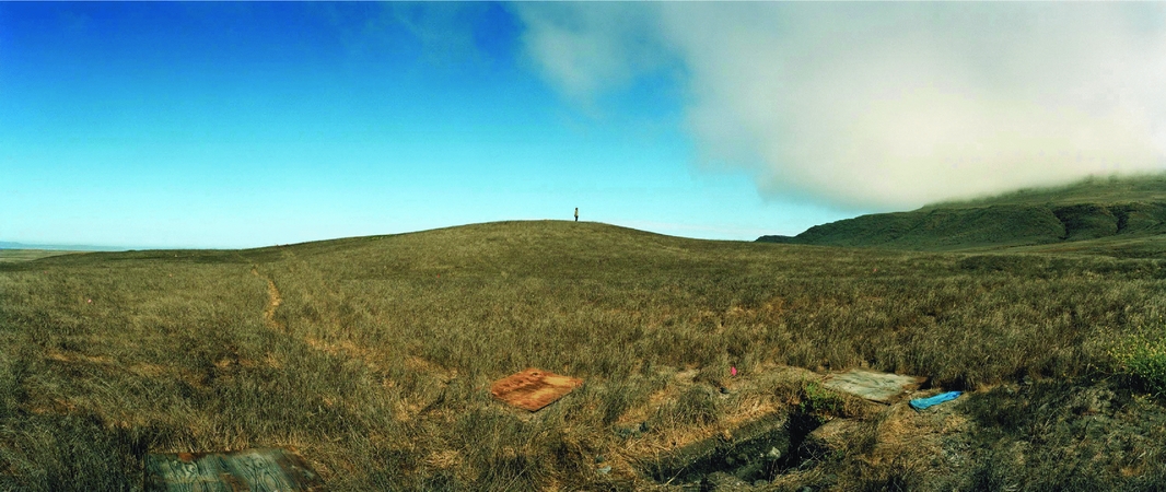
Figure 2. Person on top of El Montón (photograph by Macduff Everton).
Previous Archaeological Investigations
Olson (Reference Olson1930) conducted the earliest well-documented excavations at CA-SCRI-333 in 1927–1928 in two cemeteries and Structure 1, where he found nearly 2 m (6 ft) of cultural deposits. He uncovered 57 burials from the earlier cemetery (6,000–5,000 B.P.) and 48 from the later component (3000–2600 B.P.; Table 1). Although Olson (Reference Olson1930) only briefly published on the site, he kept relatively detailed field notes, recording burial lots, grave goods, sex, age, position, orientation, and depth.
Table 1. Cemeteries Excavated at SCRI-333.

Both King (Reference King1990) and Glassow (Reference Glassow and Jeanne2004) published on beads and other artifacts from Olson's excavations, but neither was a comprehensive study of the mortuary assemblage. Sholts (Reference Sholts2010) reexamined the human remains from the site, recording age and sex of individuals.
In 1932, Richard Van Valkenburgh excavated 132 burials (over 100 complete articulated skeletons and 32 unassociated crania) in a third cemetery that spanned the period between those Olson excavated (Table 1), but unfortunately left limited notes (Santa Barbara Museum of Natural History, “Archaeological Excavations on Frazier Point, Santa Cruz Island, California, 1932”). AMS dates from teeth of six individuals from this cemetery range between 5300–4190 cal B.P. (Monroe et al. Reference Monroe, Gonzalez, Johnson, Kruszynski and Brian2010).
Finally, Wilcoxon (Reference Wilcoxon and Glassow1993) conducted major excavations on house depressions and adjacent refuse deposits at SCRI-333 in the 1980s. Except for a brief publication (Wilcoxon Reference Wilcoxon and Glassow1993), he never completed his analysis.
Recent Archaeological Investigations
This paper discusses my archaeological investigations at CA-SCRI-333 between 2009 and 2016. One goal was to determine the occupational history of the mound, its formation processes, and its meaning. A detailed chronology of the site, achieved through excavation of selected house depressions, recovery of chronologically sensitive artifacts, and collection of radiocarbon samples within stratigraphic context, was integral to achieving this goal.
Therefore, I mapped 50 house depressions (Figure 1), many of which are in rows that appear to be on purposely constructed terraces on the mound (Figure 3). Detailed stratigraphic profiles of trenches were made, with radiocarbon samples identified on them (Figures 4 and 5). Three house depressions (Structures 2, 6, and 32) had features (Lens C) that were identified as probable burned house deposits (Figure 4). Two additional depressions lacked this lens, but one had a large burned-rock feature in its center (Figure 5b). I also analyzed notes and collections from the two cemeteries (Collection of Manuscripts from the Archaeological Archives of the Phoebe A. Hearst Museum of Anthropology, # 442, Original Field Notebooks and Photo Prints of Santa Barbara Mainland and Santa Cruz Island Excavations, Including Some Quad Sheets with Site Locations [by R. L. Olson, 1927–1928]) and identified Olson's excavation units in the field.

Figure 3. Photograph showing terraces at SCRI-333 (photograph by Macduff Everton).
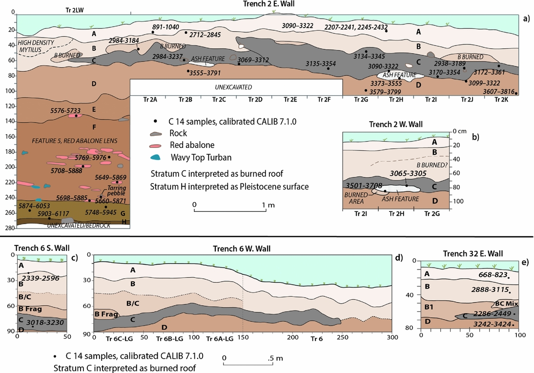
Figure 4. (a) Stratigraphic profile with AMS dates for Trench 2 east wall, (b) stratigraphic profile with AMS dates for Trench 2 west wall, ash feature, (c) and (d) stratigraphic profiles with AMS dates for Trench 6, south and west walls, (e) stratigraphic profile with AMS dates for Trench 32, east wall.

Figure 5. (a) Stratigraphic profile with AMS dates for Unit A-1, north and south walls, (b) stratigraphic profile with AMS dates for Unit 14, east wall.
Results of Current Analysis from Old and New Investigations at SCRI-333
El Montón, a Persistent Place
How and why did the site of El Montón become a place of such significance during the Early Period? I suspect that the location was originally an attraction because of the rocky intertidal zones, fresh water sources, kelp beds, sandy beaches, and cove for boats. It also commands an impressive view of Santa Rosa Island and the west end of Santa Cruz Island and the surrounding hills—significant for defensive reasons and also as a prominent place on the landscape. I propose that over time, as people visited the site, they eventually settled there, constructing thatch-covered houses and harvesting a wealth of marine resources adjacent to the site. They chose the highest part of the mound to bury their dead in rites that included endowing some who died with grave goods that distinguished them from others. Undoubtedly inherent in these rites were significant ceremonies and feasts. Other occasions, such as calendrical events like the Winter Solstice, were also probably associated with feasts. Eventually, the mound became higher and more expansive—a prominent place on the landscape that could be viewed from the sea and many surrounding settlements.
Chronology
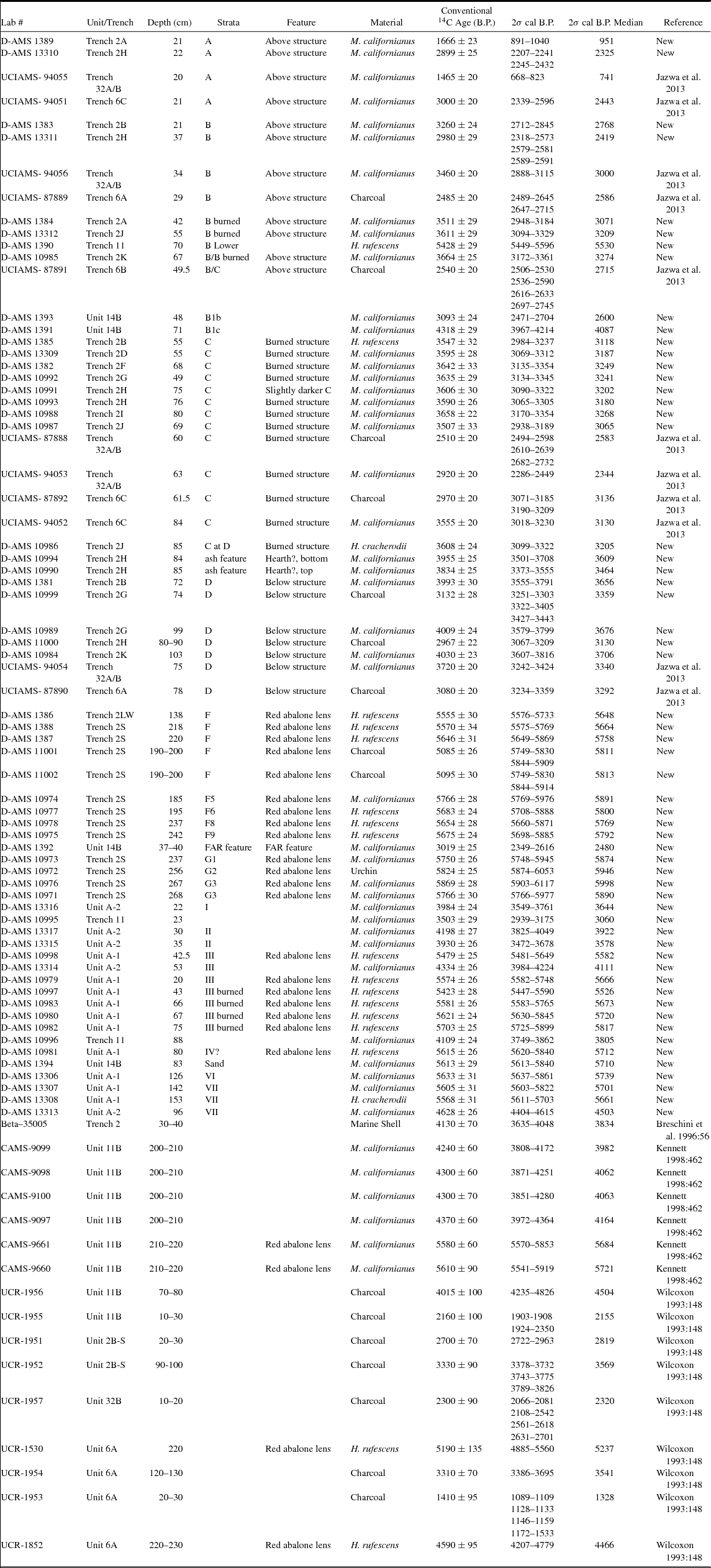
Eighty-five radiocarbon dates have been analyzed from SCRI-333 (Table 2); I obtained 69 of these 85 dates, most from shell and in clear stratigraphic context (Figures 4 and 5), 58 of which are reported here for the first time. The calibrated dates range between 668–5117 cal B.P., with all but four (95 percent) dating between 2207–6117 cal B.P. (Table 2), and are consistent with most chronologically sensitive artifacts from the site. The four dates that postdate 2207 cal B.P. are from the upper 30 cm of the site, and probably a result of people visiting later in time, not site inhabitants.
Table 2. Radiocarbon Dates at SCRI-333.
Remembering the Dead
Three cemeteries excavated in the 1920s and 1930s are immediately adjacent to each other and situated at the highest point on the mound. None of the house depressions visible at the site are in the cemetery region, suggesting that the Chumash inhabitants recognized this area as formal sacred space. Their choice of the summit probably had significant symbolic meaning, as decisions of where to place the dead are not usually based on functional expediency, but instead often have powerful meanings about social geography (Parker Pearson Reference Parker Pearson2000). In some societies, the dead still inhabit the world as spirits, and cemeteries can be viewed as a liminal space between the living and spirit world (Meskell Reference Meskell and Yoffee2007). When standing on the mound's apex, the view of the sea, Santa Rosa Island, San Miguel, and the west end of Santa Cruz Island are striking, yet visibility is limited to only certain portions of the site itself, thereby situating that space as private and prominent at the same time. Prominent places can be viewed in social contexts that help ensure rights over natural resources (Parker Pearson Reference Parker Pearson2000). The prominent mound at the west end of Santa Cruz Island can be considered a liminal interface between land and sea—a transformational space where religious rituals mark the transcendence between the material and immaterial, between life and death.
Evidence that people were not treated equally in death is apparent in both cemeteries excavated by Olson. Some individuals were buried with many grave goods, and others with nothing or very few. To measure the degree of inequality in the distribution of beads, ornaments, and other grave goods, Lorenz curves and Gini Coefficients were constructed (Figure 6 and Table 3). The Gini coefficient converts the Lorenz curves to a single number between 0 and 100 percent, allowing one to numerically compare curves. A Gini coefficient of 100 percent conveys the maximum inequality. The Gini coefficients for all artifacts and the two Lorenz curves plotted for drilled beads by burial in each cemetery (Table 3 and Figure 6) indicate clear inequality.
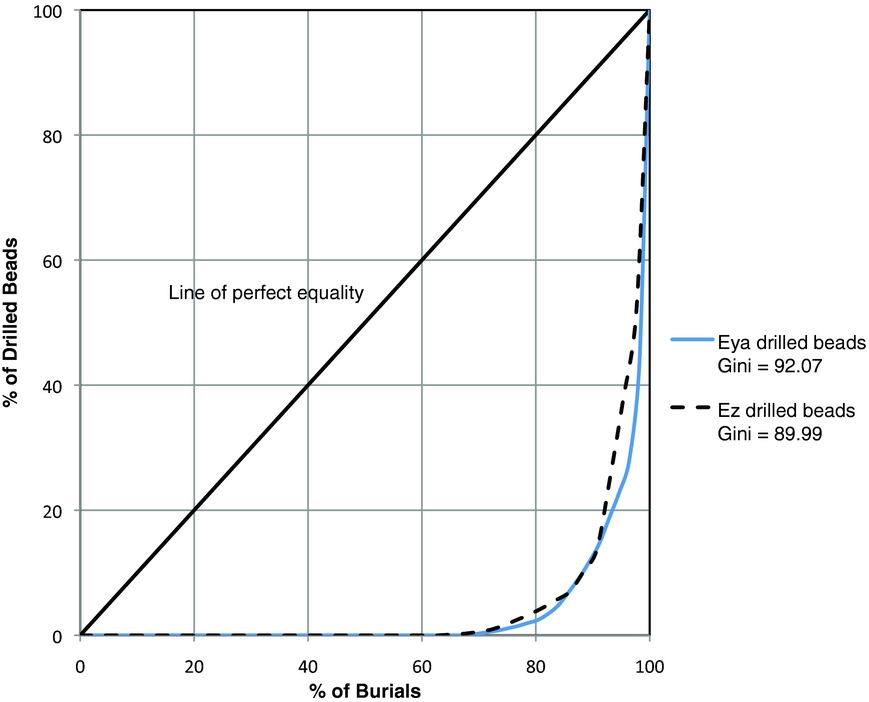
Figure 6. Lorenz curves and gini coefficient indexes of drilled beads from cemeteries Eya and Ez.
Table 3. Gini Index for Different Types of Grave Goods.

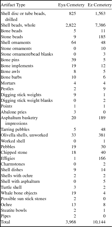
The earlier cemetery (Phase Eya, 6000–5000 B.P.) contrasts with the later one at CA-SCRI-333 and other cemeteries in the Chumash region in the higher frequency of infants and children (41.9 percent) compared with adults (Table 4). Especially intriguing are the many subadults buried with numerous grave goods (Figure 7). For example, five of the six individuals with more than 150 beads and ornaments are infants. Although Olivella biplicata (now known as Callinax biplicata) shell beads were considered a type of currency in the Late period (A.D. 1150–1804), there is no clear evidence this was the case thousands of years ago. Instead, beads and ornaments were probably items of adornment associated with higher-status individuals. The presence of many beads with infants and children implies ascribed status, or at the very least, special treatment that others were not afforded. Other, less common, types of grave goods are listed in Table 5. The later cemetery (Phase Ez, ca. 3000–2600 B.P.) is similar to the earlier one in that many subadults were buried with beads and ornaments, although the percentage of subadults compared to adults was much less. Significant literature about infants and children in the archaeological record has emerged over the last couple of decades (Kamp Reference Kamp2001; Lillehammer Reference Lillehammer2010; Sofaer Derevenski Reference Sofaer Derevenski1994); some have focused on a history of children as invisible, marginalized, and disempowered in anthropological publications (Baxter Reference Baxter2008). In certain regions of the world, archaeological evidence suggests that infants were perceived as incomplete persons, often not even afforded formal burial rites. We see that at CA-SCRI-333 they are treated similarly to adults, if not with even greater veneration, and were perceived as complete persons even as infants.
Table 4. Percentages of Infants and Children at Five Chumash Cemeteries.

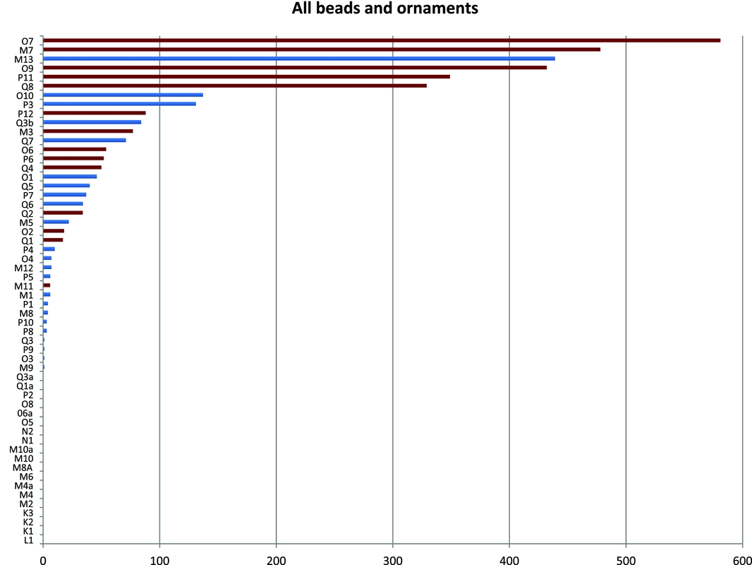
Figure 7. Graph of beads and ornaments by burial in Early Period phase Eya (6000–5000 B.P.) Cemetery at SCRI-333.
Table 5. Artifacts in Cemeteries.
The central portion of the later cemetery (Ez) is distinctive because of placement and treatment of burials, with nine individuals in extended positions, in contrast to the flexed positions of all other burials in both cemeteries. This was not a result of chronological differences, as beads and other temporally diagnostic grave accompaniments are contemporaneous (King Reference King1990) with those from the rest of the cemetery. Most of these nine were buried with a greater diversity and quantity of grave goods than other people, and, especially striking, these were the only individuals interred with black serpentine artifacts, including beads, ornaments, ornament blanks, and a small bowl. The serpentine in the cemetery is a hard stone that closely resembles that found near Figueroa Mountain in the San Rafael range on the mainland, about 80 km north of Santa Cruz Island. A most remarkable burial in this central area is an adolescent female (C7) interred with six serpentine beads. What really made her stand apart from others, however, were the associated 157 effigies (95 percent of all the effigies) (Figure 8), some of which were painted and shaped. Effigies in southern California have been interpreted as instrumental in the mobilization and control of supernatural powers (Applegate Reference Applegate1978). Although it is unknown exactly how they were used thousands of years ago, it is likely that this young woman was recognized as someone with special significance and ritual power. This is not unlike young women buried with effigies in the mainland Chumash site of Malibu during the Middle Period (Gamble et al. Reference Gamble, Walker and Russell2001).

Figure 8. Sample of effigies found in burial C7, Cemetery Ez.
The inhabitants of El Montón buried their dead at the top of the mound for over three millennia; ceremonies surrounding mourning and interment were undoubtedly significant events in the lives of the inhabitants of and visitors to El Montón (Arnold Reference Arnold and Nelson2006; Meskell Reference Meskell, Van Dyke and Alcock2003; Parker Pearson Reference Parker Pearson2000). Mortuary events have been suggested as critical in the creation of persistent places in shell mounds in Australia and the Green River Valley in Kentucky (Littleton and Allen Reference Littleton and Allen2007; Moore Reference Moore, O'Donoughue and Gilmore2015). Few material remains encountered by archaeologists are as clearly sacred as mortuary space (Moore Reference Moore2004).
Houses and Other Features
In addition to the cemeteries, approximately 50 house depressions, a possible dance area, and a possible sweat lodge have been documented at CA-SCRI-333, among other features. The house depressions range between 20–133 m2 in area each and are situated on a series of five terraces that radiate around the southern, western, and eastern portions of the mound (Figures 1 and 9). The largest depression (Structure 1, diameter = 13 m) is near the center of the mound at the highest elevation, not far from the three cemeteries. This depression had the best visibility of the surrounding settlements on Santa Cruz Island, the eastern part of Santa Rosa Island, and San Miguel Island. Hierarchy in the sizes of houses is clear (Figure 9). No occupational floors have been encountered yet. However, a highly distinctive lens (Lens C) was identified in three house depressions, and does not occur in deposits outside of house depressions. It is not a continuous stratum (Figure 4), but a lens consisting of light-colored ash with few to no artifacts. In Trench 2, fire-reddened soil was noted in a few places immediately beneath Lens C, suggesting that something burned in situ. This lens can be meters in length, and therefore does not appear to be a hearth, but a larger burned feature. Based on these data, I interpret Lens C as the remains of burned thatch (originally on the roofs of the structures) and possibly woven mats or sea grass that covered the floors. Most archaeological examples of domestic structures in the region lack clay floors, rock rings, and other distinguishing features, although exceptions exist (Gamble Reference Gamble1995).
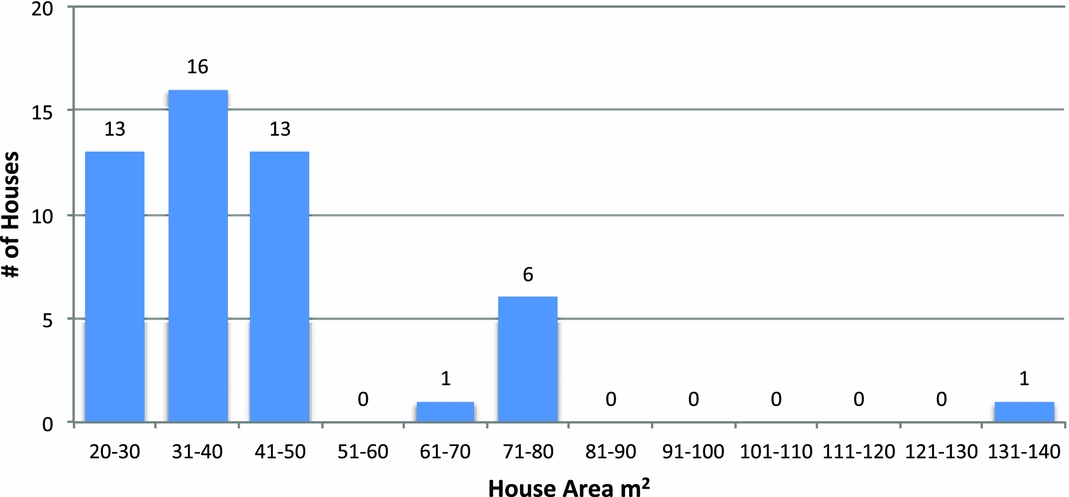
Figure 9. Distribution of house depressions by area.
AMS dates (Table 2 and Jazwa et al. Reference Jazwa, Gamble and Kennett2013) from Lens C in Structures 2 (diameter = 10 m), 6 (diameter = 8 m), and 32 (diameter = 10 m) suggest that occupation in Structures 2 and 6 overlapped (2938–3354 cal B.P. and 3018–3230 respectively). Interestingly, both are on the same terrace near the top of the mound, while Structure 32, which was apparently occupied earlier (2286–2732 cal B.P.), is situated on a lower terrace (Figure 1). Two additional dated house depressions, Structures 11 (diameter = 9 m) and 14 (diameter = 7 m), lacked Lens C, so I am uncertain whether their occupational levels are contemporaneous. GPR results indicate possible buried houses (Gamble and Simms Reference Gamble and Simms2016). However, their presence needs confirmation. Because CA-SCRI-333 was occupied for 3,800 years and all dated house deposits are in the latter 3,250 years, I expect that earlier houses not visible on the surface existed.
Although Structure 14, which is situated on the lowest terrace of the mound, lacked Lens C, a large (1 × 1.25 m) and impressive burned-rock feature was discovered (Figures 1 and 5b) that consisted of approximately 100 heavily burned rocks within a very dark and greasy soil with bits of charcoal. It is slightly concave in cross-section and much larger than average Chumash hearths. I propose that it was a rock oven that probably was used after the abandonment of the structure. The location of the feature was on the leeward side of the mound, which served as a natural windbreak. Roasting ovens in southern California have been used to cook yucca (Yucca whippelei), blue dicks (Dichelostemma capitatum), and pine nuts (Gamble and Mattingly Reference Gamble and Mattingly2012; Gill Reference Gill2015; Timbrook Reference Timbrook2007). Yucca does not grow on Santa Cruz Island; however, a burned-rock roasting pit with the remains of blue dicks was documented at CA-SCRI-619/620 (Gill Reference Gill2015). No blue dicks were found in the CA-SCRI-333 feature; however, some were recovered at the site. Thick-shelled pine nuts, probably those of Torrey Pines from Santa Rosa Island, were also at the site but not associated with the feature. Torrey Pine nuts, very large and nutritious (Gamble and Mattingly Reference Gamble and Mattingly2012), are geographically closer than mainland Grey Pines, the only other California species with thick-shelled pine nuts. Torrey Pines are rare and grow only in San Diego and Santa Rosa Island. The burned-rock feature is strikingly similar in appearance to hundreds in San Diego that are interpreted as ovens for processing Torrey Pine nuts (Gamble and Mattingly Reference Gamble and Mattingly2012).
Subsistence or Feasting
Shellfish remains are ubiquitous at El Montón and make up the bulk of the midden deposits. Most not associated with red abalone features are highly fragmented and dominated by mussel (Mytilus californianus), which usually comprises between 91 and 96 percent of the species represented by weight (Landazuri Reference Landazuri2015), followed by barnacle, black abalone, and sea urchins, with few or no red abalone. The red abalone features at the site differ significantly from other shell concentrations in that the shells are large and often whole, with red abalone consisting of 10 percent or more of the species by weight. Using multiple lines of evidence, I propose that at least one of the red abalone features may be the remains of a feasting event. I define feasting in a broad sense as communal consumption of food and or drink (Dietler and Hayden Reference Dietler, Hayden, Dietler and Hayden2001) beyond daily sharing of meals. Instead, it is sharing in more atypical contexts, such as large communal meals associated with unusual occasions within or outside the context of ceremonies, which may involve singing, dancing, and other performative acts. Archaeological indicators for feasting include the presence of rare or labor-intensive plant or animal taxa, signs of wasting of food, or the presence of exceptionally large quantities of food (Hayden Reference Hayden, Dietler and Hayden2001:39–42). Rapid deposition and minimal trampling of faunal remains are also markers of feasting.
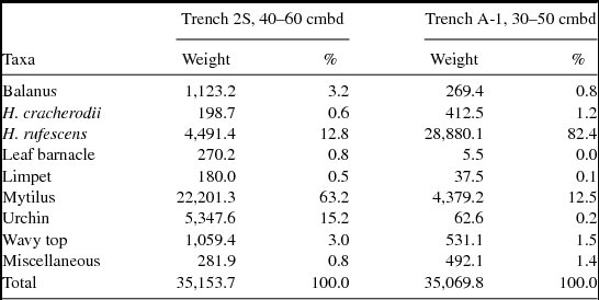
The red abalone feature (Feature 5, which is relatively close to the cemeteries) in Trench 2SLG, 110–245 cm below datum, dates between 5575–6117 cal B.P. (Figures 1 and 4a and Table 2), a period of time when sea surface temperatures (SSTs) were warmer (Braje et al. Reference Braje, Erlandson, Rick, Dayton and Hatch2009; Kennett Reference Kennett2005). The red abalone feature was about 135 cm thick, thicker than any documented on the Channel Islands. Species of shell identified for two high-density levels consist of 12.8 percent red abalone, 15.2 percent sea urchin, and 63.2 percent mussel (Table 6), more red abalone and urchin than found in other parts of the site. Most red abalone shells were stacked (possibly purposely placed), bright in color, and whole, as were mussel, many of which had both valves attached. Remarkably, some sea urchins, a fragile shell, were also relatively intact, with large portions or whole shells found in situ.
Table 6. Weight and Percentage of Shellfish Taxa in Red Abalone Features.
Although the ratio of bone to shell is only 2.1:97.9 in Feature 5, those found are noteworthy. Articulated vertebrae were occasionally found in situ, illustrating little disturbance or trampling after their deposition. For example, 12 articulated leopard shark vertebrae were in Feature 5 (Figure 10), along with 20 additional leopard shark vertebrae in the same level. Another unusual characteristic were three large fragmentary bones in one level identified as baleen whales (Mysteceti), most likely gray whale (Eschrichtius robustus). The Chumash are not known to hunt whales, so their presence is probably from beached whales. Dolphin bones (n = 18), identified only in Feature 5 at CA-SCRI-333, were similar in size and adjacent to one other, indicating limited postdepositional disturbance. Dolphin remains are relatively uncommon on Santa Cruz Island except at Punta Arena (CA-SCRI-109), a site situated on the south coast that overlaps in time with CA-SCRI-333; hundreds of dolphin remains were identified there dating between 5,300 and 6,300 years ago (Glassow Reference Glassow and Monks2005). The hunting of dolphins is often associated with seaworthy watercraft and harpoons, and some scholars consider them a high-status food (Noah Reference Noah2005). Although not nearly as many dolphin remains were found at El Montón, the presence of 18 dolphin bones suggests that dolphins were either found washed up on the beach, hunted, or perhaps imported from Punta Arena. Irrespective of how they arrived at the settlement, they are rare and significantly only found in the red abalone feature. Another unusual marine species identified in Feature 5 was one Mola mola bone, the only remains of this unusual fish found at the site. Mola mola or ocean sunfish are huge, the largest of any teleost fish, can weigh in excess of 1,500 kg (Porcasi and Andrews Reference Porcasi and Andrews2001), and are often associated with warmer waters. As with the dolphin bones, Mola mola are rare at the site and found only in the red abalone feature.
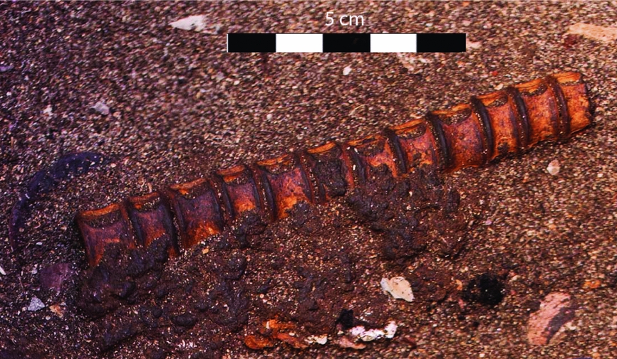
Figure 10. Articulated shark centra in red abalone feature.
Not only rare faunal remains were in the red abalone feature, but uncommon ethnobotanical remains were also. Certain taxa of plant remains found only in Feature 5 include the pits of holly-leaved cherry and manzanita, despite the fact that more liters of flotation samples were processed in other areas of the site. Holly-leaved cherry and manzanita are both important plant foods in the Chumash region. The pits of holly-leaved cherry were preferred over the fruits and required time-consuming leaching. Cherry pits were highly valued and traded between the mainland and Northern Channel Islands (Timbrook Reference Timbrook2007). Archaeobotanical samples of them are documented in ceremonial features on San Clemente Island. Their presence provides additional evidence that Feature 5 may be the remains of a feasting event.
Another prominent red abalone feature was found in Unit A-1 (Feature 7) on the north side of the mound (Figures 1 and 5a). Although its dates, 5481–5899 cal B.P. (Table 2), are similar to those in Feature 5, it differs significantly in that the shell was not as brightly colored and was not in a dark greasy soil matrix, but instead in sand. The percentage of red abalone (82.4 percent) in this feature was significantly higher than the percentage (12.8 percent) in Feature 5 (Table 6), and matches some of the high densities observed on Santa Rosa and San Miguel Islands (Braje and Erlandson Reference Braje and Erlandson2016; Braje et al. Reference Braje, Erlandson, Rick, Dayton and Hatch2009; Glassow Reference Glassow2015, Reference Glassow2016). The red abalone feature in Unit A-1 was not nearly as thick as Feature 5, (40–50 cm in thickness), with most of the red abalone occurring within a 20 cm level. Although not all bone in Feature 7 has been identified by taxa yet, relatively few bones were in the feature, with the ratio of bone to shell 0.1:99.9. Three possibly articulated dolphin vertebrae and a few tiny scattered fish bones were noted during excavation. In addition, very little charcoal compared with that in Feature 5 was recovered. Many shells were whole, but fragmented easily because they were burned, although burning did not appear to be in situ. They may have been burned elsewhere and then redeposited on the north side of the mound away from the living area. The lack of a greasy soil matrix, scarcity of bones, and lack of articulated vertebrae support the idea that this was not the remains of an in situ feasting event, but more likely redeposited shells.
The spatial distribution of red abalone provides additional clues about the nature of these features. Nineteen augers placed across the site proved especially effective, in combination with excavations of units and trenches, in the identification of buried red abalone deposits and their extent. Interestingly, red abalone features were in limited patches, versus continuous strata throughout the site. One auger a few meters from the thickest documented red abalone lens (Feature 5) had only a couple of red abalone.
In summary, at least one of the red abalone features at El Montón appears to be the result of a feasting event. First, the bright color of the shells and their intact nature, including more fragile species such as sea urchins, suggest that shells were deposited rapidly in an area of the site where there was little trampling afterward. Second, numerous AMS dates overlap in time, indicating rapid deposition. Third, the presence of rare species, some of which are highly valued and previously found in ceremonial features elsewhere, adds further evidence that Feature 5 was the remains of a feasting event. Finally, the patchy distribution of red abalone suggests that at least some of them are remains of events, not accretions developing over long periods of time. Not all red abalone features at the site appear to be a result of feasts. Some, such as Feature 7, may be redeposition of food remains, whereas others, especially those that are limited in thickness and lack rare species, may be more related to quotidian activities.
Discussion
My primary goal in this paper is to move beyond looking at shell mounds in southern California as primarily accumulations of refuse that inform us about subsistence and climate change, and instead to consider the significance of landscape and persistent places. This entails viewing them as locales that take on symbolic meanings as they are repeatedly occupied and as social memories are embodied through events that are collectively modified over time. This study differs significantly from many regional publications on shell middens because of its focus on social memory, persistent places, identity, and context. It is situated in theoretical underpinnings elaborated among scholars investigating hunter-gatherer mounds in the southeast and other regions. Although El Montón differs in construction form from many mounds elsewhere, significant parallels exist. The concept of persistent places is especially fitting in the current example. As in Australia and the southeastern United States, certain locales were occupied for centuries and even millennia after founding events such as mortuary rituals. The many features and mortuary data provide multiple lines of evidence to address issues of collective memory making, performative acts associated with the commemoration of the dead, ritual events, and significance of place.
Mortuary rituals actively reflect the construction of social orders among the living in memory of the dead through practices such as elaborate feasting and gift giving that serve to honor the deceased but also create important alliances between the living (Ekengren Reference Ekengren, Stutz and Tarlow2013; Hayden Reference Hayden2009; Mills and Walker Reference Mills, Walker, Barbara and Walker2008; Parker Pearson Reference Parker Pearson2000). Objects placed with individuals are parts of complex and transformational rituals (Bell Reference Bell1992) and, as such, provide symbolic meanings that may differ outside these ceremonial contexts. Ceremonies commemorating individuals are moments that will be remembered, contested, and reinterpreted over time (Mills and Walker Reference Mills, Walker, Barbara and Walker2008).
The Chumash at El Montón recognized the top of the mound as a sacred space, a sanctified area where, for thousands of years, they conducted rituals centered on honoring the dead. Not all those who died were treated equally; some had many more grave goods than others. Infants and children were treated very much like the adults. Claims that institutionalized social inequalities did not exist as early as 6000–2500 B.P. in the Santa Barbara Channel region are not supported by this study; instead, these data confound the concept that people were relatively equal thousands of years ago. Otherwise, why were some infants and children not afforded the same recognition at death as others, or adults? I suggest that not everyone was equal.
Especially intriguing are the burials in the central portion of Cemetery Ez at CA-SCRI-333. Here we see individuals buried in extended positions, instead of flexed with rare trade items such as serpentine beads, ornaments, and a bowl. The adolescent girl buried in an extended position with 157 stone effigies clearly was treated differently than others, perhaps because of special powers she possessed. These patterns compel us to rethink this early period of time—the differential treatment of people in death most likely mirrors differential treatment in life.
El Montón differs from other sites on the northern Channel Islands in the size of the massive shell mound and its 50 visible house depressions (in addition to probable buried ones), many more than any other site. Most sites from this period have less than five visible depressions and are much smaller than CA-SCRI-333 (Gamble and Barbier Reference Gamble and Barbier2015), which was most likely a center where people from surrounding settlements assembled for ritual gatherings, knowledge exchange, potential marriage partners, and many other reasons. It differs from some Archaic sites in southeastern United States, such as Watson Brake, in that it is not an earthen mound, does not appear to have been planned, and has evidence of residential living in addition to ceremonial features. Despite these differences, the presence alone of hunter-gatherer mounds as massive as those at Watson Brake and El Montón over 5,000 years ago challenges traditional concepts of early hunter-gatherer groups as egalitarian, generalized foragers (Sassaman and Heckenberger Reference Sassaman, Heckenberger, Gibson and Carr2004). Instead, the mounds are testimony to transformations in the landscape and in society—a reflection of greater hierarchy.
I propose that the shell mound at El Montón originally attracted maritime-oriented populations because of its ideal location, including abundant resources. Its calm anchorage, the best on the west end of Santa Cruz Island, allowed early mariners to interact with populations on the northern Channel Islands as well as mainland Santa Barbara. It became a persistent place that was repeatedly occupied over long periods of time. Early visitors feasted on red abalone, urchins, sea mammals, and other marine delicacies during ceremonies, whether for mourning (Hull Reference Hull2014) or annual rites such as the winter solstice. Mortuary rites conveyed the symbolic power of the place and created a history of events that became part of a mythical and real past. El Montón was repeatedly visited, modified, and (re)interpreted as social relationships were reinforced. Over time, the mound, whether purposely built higher or not, became more prominent and visible. Leaders with ritual power, wealth, distinction, and exotic goods emerged as social inequality increased.
El Montón clearly fits the characterizations of persistent places as discussed by Schlanger (Reference Schlanger, Rossignol and Wandsnider1992) and Thompson (Reference Thompson, Thomas and Sangar2010): (1) its location is near easily accessible concentrations of significant resources; (2) the natural features at the site (i.e., the anchorage, situation on a low mound) made it desirable for repeated use; and (3) it was created through practice over an extended time period. El Montón is similar to sites in the southeast, Australia, Brazil, and central California in the prominence of mortuary features, some of which may have been critical in the founding of persistent places.
Conclusion
By situating investigations of mounds like El Montón within a broader interpretive lens, we see that the building of mounds, whether intentional or not, is widespread among hunter-gatherers in the world. Features such as terraces, remains of feasting events, dedicated cemeteries, and remains of ritual events are well documented. Some mounds, such as El Montón, are thousands of years old, persistent places recognized for millennia. Whether scholars view these as monumental or not, their mere presence is significant in (re)interpretations of hunter-gather societies as more than simple foragers in an evolutionary schema that leads to sedentary agriculturalists. By taking a historical perspective, we see early practices of Chumash Indians that developed in situ for thousands of years. In interpreting the archaeological evidence at El Montón, it is difficult to tease out the ritual from everyday life. Fowles (Reference Fowles2013) reminds us that separating secularism from religion reflects a Western perspective, a position that can significantly differ from those of premodern people. Daily practice was probably intimately tied to ritual events associated with ceremonies or religious beliefs in the past, obfuscating the identification of secular versus religion.
The massive mound at El Montón on the west end of Santa Cruz Island can be interpreted in multiple ways. Clearly much of the mound consists of the refuse of meals—fragments of shells and bones deposited for thousands of years. The relatively shallow house depressions attest to people living at the site and hundreds of burials suggest many died there. They had children, and hunted, gathered, and fished for a living. Diets shifted with changes in climate, as sea-surface temperatures warmed and cooled during repetitive El Niño-Southern Oscillation (ENSO) cycles. Longer-term climatic events too, such as extended droughts and wet-periods, challenged the Chumash who lived there for millennia. All these issues are significant, particularly with the challenges that we face now and in the upcoming centuries, but there is more to El Montón than adaptation to changing environments. As noted in the beginning of this paper, archaeologists throughout the world are excavating and analyzing shell mounds in unique ways. I hope this paper inspires archaeologists working in southern California to contemplate these intellectual trends and think about shell middens in a broader theoretical and cultural context.
Acknowledgments
The project was funded by the Wenner-Gren Foundation for Anthropological Research, the National Geographic Society, UC Santa Barbara (UCSB) ISBER Social Science Research Grants Programs, UCSB Academic Senate Faculty Research Grants, and the UCSB Department of Anthropology. I especially thank Lyndal Laughrin of the Natural Reserve System and David Dewey of the Nature Conservancy for logistical support, and Macduff Everton and Dan Van Dorn for photography and graphics, respectively. I am indebted to many students, particularly Brian Barbier, Erin Bornemann, Tsim Schneider, Peter Nelson, Kristina Gill, Glenn Russell, and Hugh Radde. I especially thank Patricia Chirinos Ogata, who translated the abstract, and the Chumash Indians, including Gil Unzueta, Julie Tumamait-Stenslie, and the Santa Ynez Band of Chumash. I also acknowledge Tim Pauketat, Susan Alt, Mike Glassow, Greg Wilson, Jon Erlandson, and Amy Gusick for insights in the field. Natasha Johnson and Mari Lyn Salvadore assisted at the Phoebe Hearst of Museum of Anthropology and John Johnson, Jan Timbrook, and Ray Corbett at the Santa Barbara Museum of Natural History. I thank Eric Wohlgemuth for analysis of archaeobotanical remains and Tom Wake for analysis of faunal remains. I also thank Glenn Russell, Tom Blackburn, Brian Barbier, Erin Bornemann, Hugh Radde, Doug Steiderwald, and three anonymous reviewers who commented on drafts. Finally, I am grateful to Robert Kelly for assistance in improving this paper.
Data Availability Statement
Field Notes from Gamble and Wilcoxon's excavations are on file at the UCSB Repository for Archaeological and Ethnographic Collections. Collections and notes from the cemeteries are at the Phoebe Hearst of Museum of Anthropology and the Santa Barbara Museum of Natural History.


