Migration is a key demographic variable and one that archaeologists contend with around the world (Anthony Reference Anthony1990). Archaeological case studies of migration among Southwest agriculturalists emphasise several key variables, including distances moved, the size and social composition of migrant and host groups, and pre-existing relationships with host communities (Ortman & Cameron Reference Ortman and Cameron.2011). A complementary idea is that coalescence and cultural contact produce ethnic co-residence, new social institutions and potential inequalities between first-comers and later arrivals (e.g. Birch Reference Birch2012).
Migration is also important for interpretations about the origins and historical trajectory of Chaco Canyon and the greater Chaco World. As one of North America’s iconic archaeological examples of emergent complexity, Chaco provides an opportunity to examine how migration intersects with other social variables. Based on multiple lines of artefactual and architectural evidence, archaeologists propose different migration scenarios involving movements into or out of Chaco Canyon, and tie these to broader social and political developments across the Southwest. Given the significance of migration to contemporary Southwest peoples (e.g. Naranjo Reference Naranjo1995), it should be unsurprising that migration was also a significant part of Chaco’s history (Lekson & Cameron Reference Lekson and Cameron.1995; Clark & Reed Reference Clark and Reed.2011).
While there are long-standing debates about the size of resident populations in Chaco Canyon, aggregation and coalescence were important processes of village growth. Inequality was also part of Chaco’s social fabric, dating to Pueblo Bonito’s earliest construction in the ninth century AD (Plog & Heitman Reference Plog and Heitman.2010). Several Chaco scholars have explicitly tied this inequality to immigration (e.g. Vivian Reference Vivian1990; Crown & Wills Reference Crown and Wills.2003; Judge & Cordell Reference Judge and Cordell.2006). Differences between the two major burial clusters at Pueblo Bonito (Akins Reference Akins1986) and the contrast between small and great house architecture within the canyon are often cited as evidence for the presence of people with disparate origins and identities (Wills Reference Wills2009). Understanding migration in the Chaco World is not only important for understanding its uniqueness in the Southwest, but for providing a comparison to other case studies worldwide.
To accomplish such comparisons, we must disentangle Chaco’s migration history. When did these migrations occur? At what social scales? And along which pathways? Archaeologists who study migration recognise that people generally do not move to areas with which they have had no prior social contact. In other periods of Southwest migration, social network connectivity both preceded and was the result of movement of people at the regional scale (e.g. Mills et al. Reference Mills, Clark, Peeples, Haas, Roberts, Hill, Huntley, Borck, Breiger, Clauset and Shackley.2013a & Reference Mills, Roberts, Clark, Haas, Huntley, Peeples, Borck, Ryan, Trowbridge and Breiger.b, Reference Mills, Peeples, Haas, Borck, Clark and Roberts2015). Here, we use these methods to examine Chaco migration in order to: 1) take a regional perspective; 2) apply a consistent temporal scheme; and 3) consider interaction using dynamic social network analysis (SNA). These analyses serve to complement the numerous influential studies focused on untangling the history of settlement and population movement for specific Chaco settlements or specific regions of the broader Chaco World.
Methods
We build on methods developed by the Southwest social networks project for defining and analysing networks of similarity based on ceramic frequency data (Mills et al. Reference Mills, Clark, Peeples, Haas, Roberts, Hill, Huntley, Borck, Breiger, Clauset and Shackley.2013a &Reference Mills, Roberts, Clark, Haas, Huntley, Peeples, Borck, Ryan, Trowbridge and Breiger.b, Reference Mills, Peeples, Haas, Borck, Clark and Roberts2015; Peeples & Roberts Jr Reference Peeples and Roberts2013). We compiled locational, size and architectural information on 467 settlements with a great house and/or a great kiva dating between AD 800 and 1200 from across the Chaco World (Figure 1; Peeples et al. Reference Peeples, Mills, Clark, Aragon, Giomi and Bellorado.2016). We define nodes in our networks as the 325 settlements for which systematic ceramic type-ware counts (≥30 identified sherds) are available (totalling more than 1.9 million sherds). The 30-sherd minimum is based on prior analyses that randomly resampled assemblages and nodes to assess the sensitivity and robustness of the methods (see Mills et al. Reference Mills, Roberts, Clark, Haas, Huntley, Peeples, Borck, Ryan, Trowbridge and Breiger.2013b). For the networks discussed below, we focus on frequencies of painted ceramic wares. In the Southwest, wares are defined by similarities in technology—especially temper and paint choices—and design. In the Chaco area, these are broadly attributable to different production zones. The Chuskan area in particular was a major supplier of white and grey ware pottery to surrounding areas, especially Chaco Canyon, approximately 70km from Pueblo Bonito (Toll Reference Toll2006). Red and brown wares also circulated widely from areas to the south (Crown Reference Crown2016). We rely on painted wares as they tended to circulate across larger areas than unpainted wares and have been more consistently recorded. In additional analyses, we also use systematic counts of unpainted ceramics, where data are available.
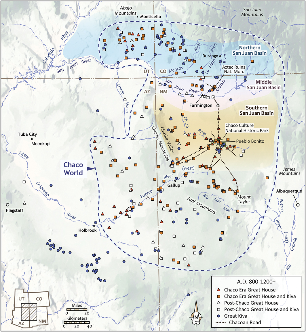
Figure 1 Locations of Chaco and post-Chaco-era great houses and great kivas within the Chaco World (figure by Catherine Gilman).
As we are interested in tracking network change, we use a set of systematic procedures for defining the occupation spans of our 325 nodes and apportioning the ceramic assemblages into 50-year intervals. Specifically, we build on a Bayesian method for modelling site occupations recently published by Ortman (Reference Ortman2016). This approach combines information on the date ranges assigned to pottery types with ceramic frequency data for individual sites to model the probability that a site was occupied during any given year. This technique works to maximise overlaps in the production spans of types, and typically produces date ranges shorter than the maximal range of dates associated with types at that site, thereby allowing for greater chronological control. In this study, we applied Ortman’s (Reference Ortman2016) technique to define discrete start and end dates for each site to include the interval between the earliest and latest dates with greater than 0.025 probability of occupation, according to the Bayesian model. This approach provides dates that conform well to absolute dates, where available, and avoids the inclusion of minor secondary occupations. Based on these systematically assigned site dates, we then apportioned the ceramic assemblages for each site into discrete 50-year intervals. The apportioning procedure assumes a normal popularity curve for each type. It also uses the site start and end dates defined above, the dated production ranges of each temporally distinct type within each ware, and changes in population size and deposition rates through time in order to estimate the proportion of ceramics deposited in each interval in which that site was occupied (Roberts et al. Reference Roberts, Mills, Clark, Haas, Huntley and Trowbridge.2012). The procedure is designed to address problems associated with comparing assemblages from sites with different occupation lengths.
Using the apportioned ceramic counts for each site for each interval, we define weighted networks of similarity using the percentages of painted ceramic wares recovered from each site. We use the Brainerd-Robinson similarity measure to weight ties between every pair of sites in each temporally sequenced network, and treat the weights of ties between sites as a general indication of the probability of connection among them. To explore variation in the importance of (groups of) sites in directing and receiving flows through the network, we also calculate eigenvector centrality scores for each node in each interval (see the online supplementary material (OSM), Tables S1–8). Eigenvector centrality is a frequently used measure of the importance of nodes for networks that captures multiple flow processes (see Mills et al. Reference Mills, Roberts, Clark, Haas, Huntley, Peeples, Borck, Ryan, Trowbridge and Breiger.2013b).
In addition, we use community-detection methods for each 50-year interval to identify subgroups of nodes that are highly connected in our weighted networks. Specifically, we use the walktrap algorithm, which defines network subgroups by simulating a large number of short (five steps in this case) random walks from node to node across the network. At each step, the probability that a given node is chosen is proportional to the strength of the connection between the current node and each target node. This algorithm produces intuitively useful partitions of complex networks by determining communities characterised by consistently overlapping random walks (Pons & Latapy Reference Pons and Latapy.2005).
Finally, for the purposes of visualisation, we display binary networks by defining similarities in the upper quartile of all scores for each interval as ties. It is important to note that, although the results of our centrality and community-detection analyses are shown on the binarised network maps, these analyses utilise the full weighted raw similarity scores. Our approach to constructing ceramic similarity networks is based on the relative consumption or discard of different wares, which represents the choices made by households at each site (Mills Reference Mills2016). Thus, we are not exploring the differences in production areas alone, but the cumulative choices resulting from different kinds of social interactions (e.g. visitation, exchange, emulation), which produce discard assemblages. These pairwise relationships help to define probabilities for interaction, the strength of social linkages that might have fostered migration, and relationships that built upon prior migrations. Another way to look at this is that the absence of connections between different great houses and great kivas is evidence for the lack of ties and for lower probabilities for interaction and migration. Thus, the gaps are as important as the connections.
In some of our analyses, we compare networks to selected ceramic technological attributes. Here, we limit it to interior smudging, which occurs largely on unpainted wares, and is thus independent of how we derive our networks. In doing so, we offer new interpretations about the directionality and intensity of ties between Chaco Canyon settlements and the surrounding region at different points in the Chaco World’s historical trajectory. Our analysis represents the first attempt to apply a consistent, quantitative dating scheme to the regional database of great houses and great kivas—one that began with Kantner’s Chaco outlier compilation (http://www.chacoarchive.org/cra/outlier-database/), subsequently supplemented by data collected by our project and the Chaco Landscape Project (Van Dyke et al. Reference Van Dyke, Lekson and Heitman2016).
Chaco migration scenarios
Previous research has identified three periods in which migration may have played an important role in shaping the historical trajectory of the Chaco World. These are: 1) migration from the Mesa Verde area to Chaco Canyon and other Southern San Juan Basin settlements in the AD 800s; 2) migration from Chaco Canyon to other areas of the San Juan Basin and beyond in the AD 1000s and 1100s; and 3) migration from the Northern and Middle San Juan to Chaco Canyon in the AD 1100s (for subregional areas see Figure 1). Each of these scenarios proposes the movement of households to new locations, with implications for co-residence and social transformation.
Migration scenario 1
The first scenario focuses on the founding of great houses in Chaco Canyon, in the ninth century AD (Figure 2). New chronological analyses continue to push back the timing of not only the construction of great houses, but also provide strong evidence for inequality in mortuary practices, the acquisition of rare and long-distance resources and ritual deposition at scales that were unmatched at contemporaneous settlements (e.g. Crown & Hurst Reference Crown and Hurst.2009; Plog & Heitman Reference Plog and Heitman.2010; Watson et al. Reference Watson, Plog, Culleton, Gilman, LeBlanc, Whiteley, Claramunt and Kennett.2015). While most archaeologists acknowledge that Chaco Canyon attracted new people, a debate has emerged about their origins.
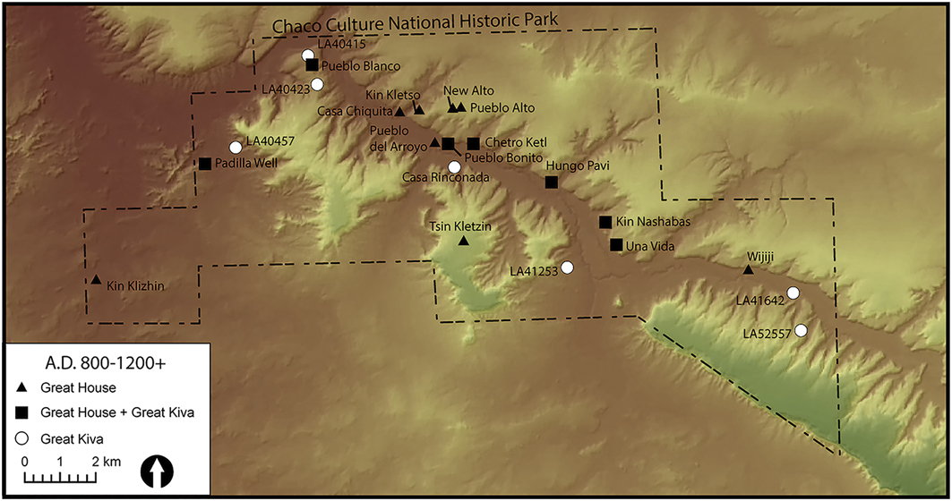
Figure 2 Location of great houses and great kivas in Chaco Canyon (figure by Matthew Peeples).
Several archaeologists argue that immigrants from the Northern San Juan area in south-western Colorado founded great houses at Chaco. The evidence includes high population densities during the AD 800s in the Northern San Juan, masonry that resembles the Type I Chaco style, crescent-shaped settlement layouts and inferred political and religious authority at sites in south-western Colorado (Wilshusen & Ortman Reference Wilshusen and Ortman.1999; Judge & Cordell Reference Judge and Cordell.2006; Wilshusen & Van Dyke Reference Wilshusen and Van Dyke.2006; Windes Reference Windes2007, Reference Windes2015; Windes & Van Dyke Reference Windes and Van Dyke.2012; Wilshusen Reference Wilshusen2015). Due, however, to the extensive remodelling at Pueblo Bonito (see Crown & Wills 2018), and to the limited number of excavations of the earliest construction episodes at outlying great houses, this proposition is difficult to evaluate. More recently, Windes (Reference Windes2015: 685) has investigated potential evidence for such a migration stream focusing on the founding of several proto- and early great houses. He argues that the AD 800s migration from the Northern San Juan centred on great houses to the west of Chaco Canyon along the Chaco River corridor, which had strong artefactual ties with the Chuskan area. Within Chaco Canyon, however, east of Pueblo Bonito to Pueblo Pintado, there is evidence of new communities arriving from both southern and northern regions in the late AD 800s, but revealing sparse Chuskan interactions.
On the other side of the debate, several archaeologists have proposed that the early inhabitants of Chaco Canyon had connections with many areas, not necessarily including the Northern San Juan. Price et al. (Reference Price, Plog, LeBlanc and Krigbaum.2016), for example, have used isotope analysis of human remains, comparing Pueblo Bonito individuals from Room 33—one of the richest burial chambers in the Southwest—with individuals from sites to the north and north-west. They found that the isotopic signatures for Pueblo Bonito individuals did not overlap with those from northern areas. Instead, there was considerable variation, but the closest associations were to areas surrounding Chaco Canyon. In another recent study, Guiterman et al. (Reference Guiterman, Swetnam and Dean2015) found that construction timbers from Pueblo Bonito’s earliest rooms were sourced from the Zuni Mountains, to the south. Crown’s (Reference Crown2016) recent analyses of ceramics from Pueblo Bonito also suggest that among all the ‘non-local’ pottery, there is an unexpectedly high frequency of smudged ceramics, which are more common in assemblages along the southern edge of the Chaco World.
Analysis of the ceramic networks in 50-year intervals informs this debate by demonstrating a gap between the Northern San Juan and Chaco Canyon during the early ninth century (Figure 3: left). In network terms, there are two components: a well-connected Northern San Juan subgroup that is unconnected to Chaco sites along the east flank of the Chuska Mountains, and those west of Chaco Canyon. In the latter half of the ninth century (Figure 3: right), sites along the Rio Chaco were well connected to each other, sites in Chaco Canyon and those immediately surrounding the canyon, but they were still unconnected to the northern component. Of particular interest during the AD 850–900 period is the number of strong ties extending to the south-west as far as the Rio Puerco and the south-west Zuni areas. These patterns are further evident in the community-detection analyses, which show distinct northern and southern subgroups for both intervals, with a few sites along the edges of these groups (in yellow) that are transitional between these two communities.
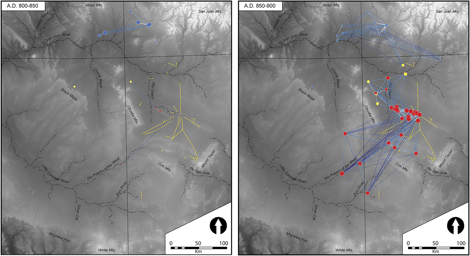
Figure 3 Chaco great house and great kiva networks. Left: AD 800–850; right: AD 850–900. For all network figures: the intensity of blue indicates greater distance of ties, and the size of nodes is based on eigenvector similarity (non-binarised, weighted ties); node colours differentiate groups identified through community-detection analysis; and Chaco roads are shown in yellow for reference (figure by Matthew Peeples).
The ninth-century pattern extended into the tenth century, with the San Juan River continuing as a boundary or gap in the network (Figure 4). In fact, the first half of the tenth century shows a larger gap between the southern and northern areas than previous periods. The community-detection analyses defined two discrete groups, with Chaco and the surrounding areas falling within the community largely representing settlements to the south (in red). Between AD 950 and 1000, several of the southern component sites just south of the San Juan River gain centrality, but there is still a gap between the southern and northern components. By the end of the tenth century, dense areas of connectivity encompassed Chaco Canyon buildings, extending to the west and south.
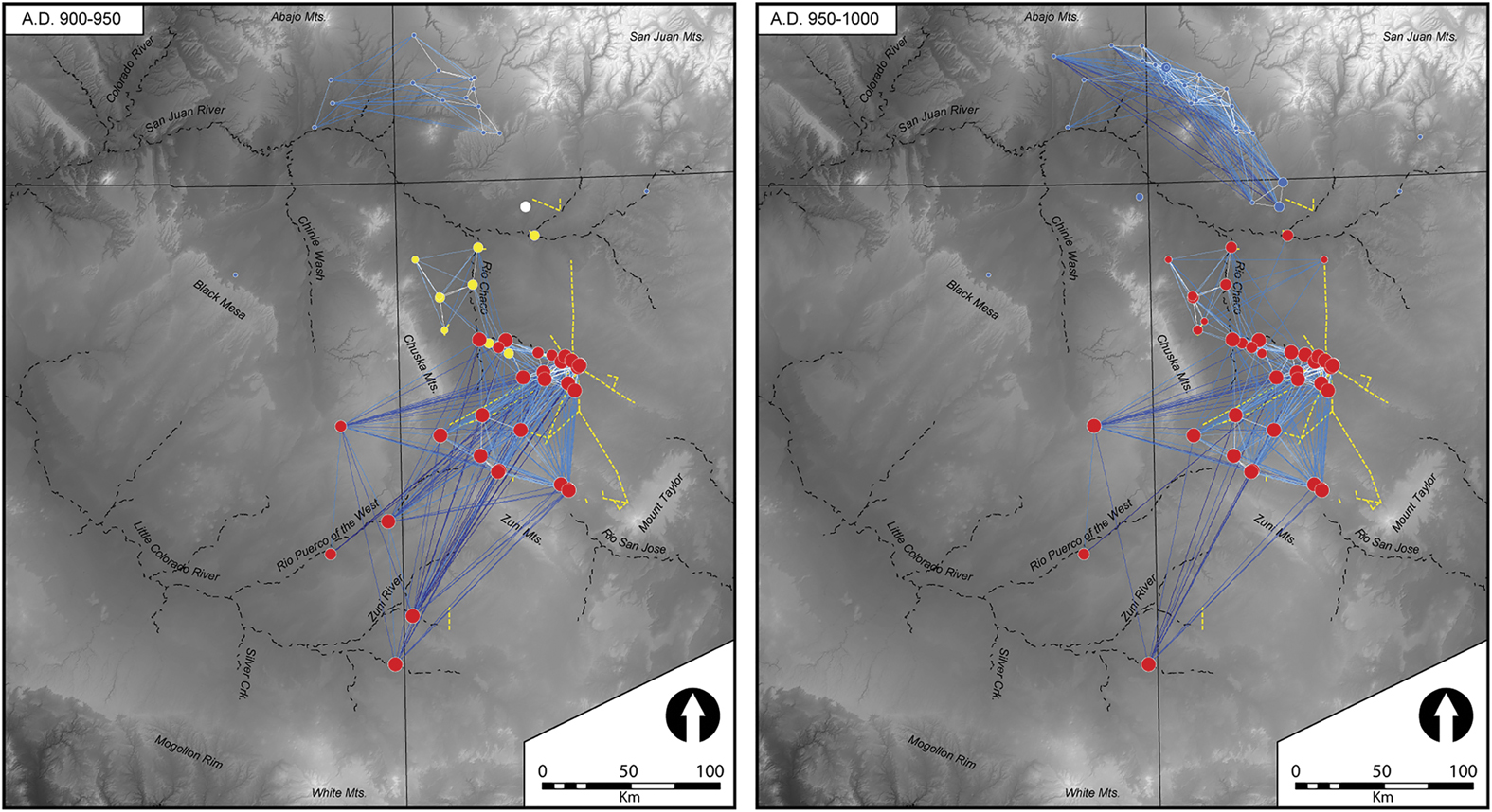
Figure 4 Chaco great house and great kiva networks. Left: AD 900–950; Right: AD 950–1000 (figure by Matthew Peeples).
These networks suggest a lack of strong connections between the Northern San Juan and Chaco Canyon during the formative centuries of the Chaco World. Instead, strong ties are present between Chaco Canyon, the Chuska slope and the Upper Rio Puerco (of the West), which therefore better fits Windes’s model. Also supporting strong ties with the West are similarities discussed by Webster et al. (Reference Webster, Cordell, Hays-Gilpin and Jolie.2014) between the perishable ritual technologies from Chaco Canyon and Basketmaker III assemblages from the Chuska region. They point out several commonalities, including burden baskets (and their ceramic effigies), twined yucca sandals and wooden ritual objects. This is also the period in which large quantities of Chuskan ceramics were first distributed throughout much of the Chaco area, up to 75km from their production sources (Toll Reference Toll2006). While our network reconstructions are based on decorated ceramics, it is worth noting that Chuskan Greyware was also produced in the Chuska Mountains and consumed in high quantities throughout the Chaco World. The paucity of pottery-firing fuels in the canyon is a major explanation for the high degree of pottery movement, which clearly built on earlier connections among Basketmaker III settlements.
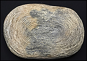
Chaco Canyon’s ties to the south and south-west might be expected, given shared production and consumption of Cibola White Ware pottery, which was made over a large area of the San Juan Basin. Other ceramic wares, however, complement these strong ties. The higher than expected proportions of smudged brown and red wares are an intriguing aspect of Pueblo Bonito’s assemblage. Crown (Reference Crown2016: 121) suggests that these wares provide evidence of long-distance exchange networks, and possible clues to Chaco migration histories. The presence of smudged red and brown wares, however, is not necessarily evidence of long-distance connections, given that they were also produced in the Puerco Valley (Fowler Reference Fowler1991) and the Quemado area (Duff & Nauman Reference Duff and Nauman.2010)—both of which hosted Chaco great houses and communities. The earliest smudged ware in the Rio Puerco area is Woodruff Smudged, which was produced as early as AD 500 and continued until 1000 (Hays-Gilpin & van Hartesveldt Reference Hays-Gilpin and van Hartesveldt.1998: 151). The distribution of Woodruff Smudged in assemblages dating to between AD 800 and 1000 is sparse but concentrated in Chaco Canyon great houses (Figure 5: left). One small, Woodruff Smudged bowl was placed in the corner of Room 33, associated with the first two elite burials and below a wooden plank floor. While smudging is anomalously high at Pueblo Bonito compared to other sites in Chaco Canyon, many sites to the south and south-west show similarly high proportions (Figure 5: right). Crown (Reference Crown2016) has recently argued that the iridescent smudged brown and red wares may have been used as mirrors. Smudging persisted after AD 1000 on Show Low Red Ware and Corrugated Mogollon Brown Ware (Hays-Gilpin & van Hartesveldt Reference Hays-Gilpin and van Hartesveldt.1998; Crown Reference Crown2016). Both occur in unusual elongated bowl forms, including two from Pueblo Bonito’s Room 32 (Figure 6). This room contained hundreds of ceremonial items that were ritually retired (Mills Reference Mills2008). Another example (AMNH H/3656) was found in the ‘debris’ from Room 33, and was associated with multiple rich burials related through matrilineal descent (Kennett et al. Reference Kennett, Plog, George, Culleton, Watson, Skoglund, Rohland, Mallick, Stewardson, Kistler, LeBlanc, Whiteley, Reich and Perry.2017). It is similar to a rectangular vessel of the same ware from Room 51 in the East Wing of Aztec Ruin (Morris Reference Morris1919: fig. 46). Both are unusual shapes and occur in rooms that were used for the storage and retirement of ritual objects. These examples post-date AD 1000 and relate to the next migration scenarios, but point to historically deep connections. In summary, the available evidence indicates that the original inhabitants of Chaco Canyon, especially Pueblo Bonito, had stronger ties to settlements to the south and west rather than with the Northern San Juan region.
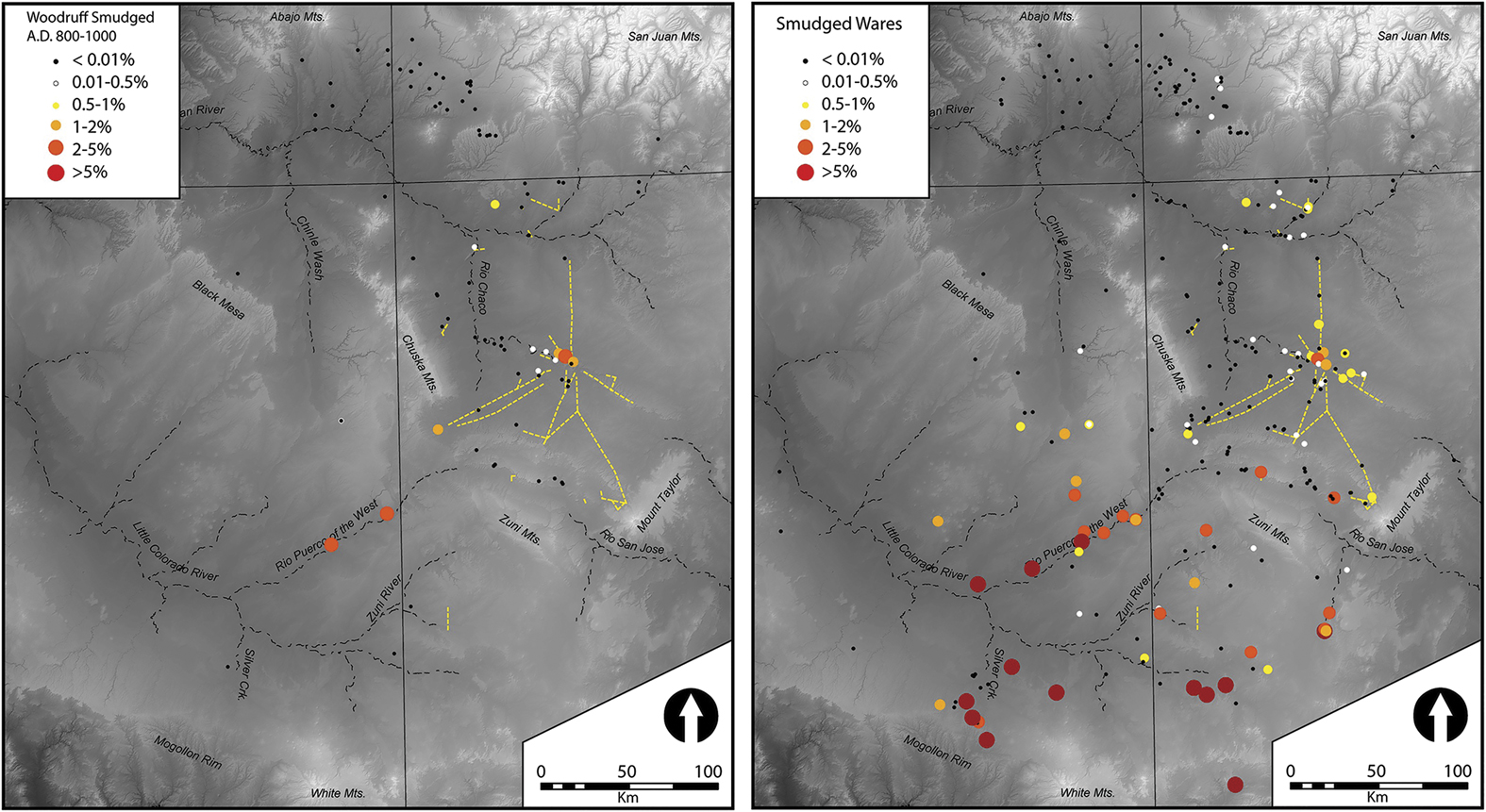
Figure 5 Left: percentages of Woodruff Smudged in Chaco great house and great kiva assemblages between AD 800–1000; right: percentages of all smudged brown and red ware at Chaco great houses and great kivas (all time periods) (figure by Matthew Peeples).
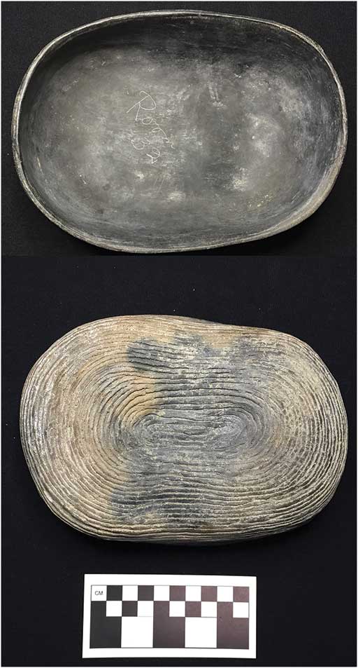
Figure 6 Reserve Corrugated Smudged oblong bowl, Pueblo Bonito, Room 32 (fill), c. AD 1050–1250 (AMNH H/3647) (photograph by Barbara Mills, courtesy of the American Museum of Natural History).
Migration scenario 2
The second major proposed migration is the eleventh-century movement out of Chaco Canyon to expand existing outliers and to establish new ones. Explicit investigation of migration from the receiving end has focused on Aztec Ruins and its neighbours along the Middle San Juan, to evaluate whether material culture similarities can be attributed to emulation, exchange or actual migration (Clark & Reed Reference Clark and Reed.2011; Reed Reference Reed2011; Webster Reference Webster2011). These researchers concluded that migration out of Chaco Canyon to the Middle San Juan occurred in the late 1000s and early 1100s.
During the first half of the AD 1000s, nodes in Chaco Canyon and its immediate surroundings closely interacted, and the Great North Road became a conduit of connectivity (Figure 7). The Northern San Juan was still relatively disconnected and, as the size of the nodes indicates, Chaco Canyon great houses were less central within the full network. After AD 1050, however, the Chaco Canyon community became more linked to the greater Northern San Juan area through connections at Aztec and other settlements on the San Juan River. More nodes—and more connected nodes—are present throughout the Chaco World. This and the subsequent periods are the only intervals in which the southern and northern components are strongly connected in the network diagrams; those ties are via great houses and great kivas that are on the Great North Road, on the San Juan River, or the Animas River (especially Aztec). The community-detection analyses show two strong communities for this interval divided primarily between the Northern San Juan and areas farther south. Importantly, Aztec and several other large great houses north of the San Juan River became part of the southern community (in red). Our results show slightly earlier strong ties than have been suggested for this second migration scenario. Overall, the SNA results mirror reconstructions showing the expansion of the Chaco World to its maximum extent in the late AD 1000s, the high centrality of nodes along formal Chaco roads for the first time and the growing importance of the Middle San Juan great houses. These results parallel analyses from the Northern San Juan that delineate Chaco expansion into the Mesa Verde area from AD 1060–1100 (Crabtree et al. Reference Crabtree, Bocinsky, Hooper, Ryan and Kohler.2017: 88). More central to the regional network, however, are sites along the Rio Puerco and those in the southern Chaco World, indicating the maintenance of long-term ties to these areas.
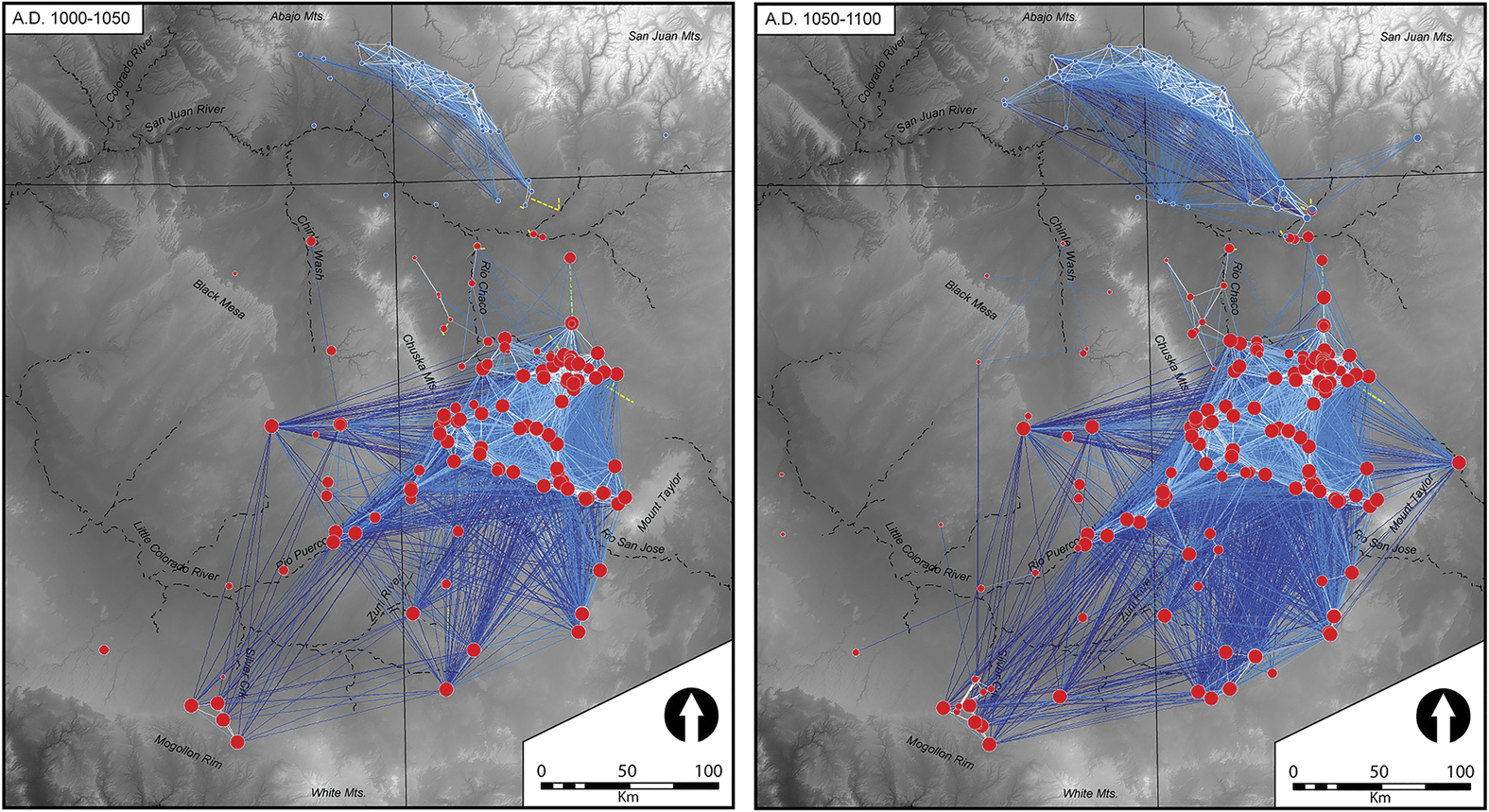
Figure 7 Chaco great house and great kiva networks. Left: AD 1000–1050; right: AD 1050–1100 (figure by Matthew Peeples).
Migration scenario 3
Wills (Reference Wills2009) evaluated evidence for the serial use of Chaco Canyon, focusing on emigration from Chaco to other areas in the late 1000s and immigration from the Middle and Northern San Juan regions to Chaco in the early 1100s. He contrasts his interpretation with that of Lekson (Reference Lekson1984), who suggested that the McElmo architectural style—the hallmark of the twelfth century—originated in Chaco and was adopted by those in northern settlements.
The network diagrams for the AD 1100s show that Chaco great houses and great kivas in Chaco Canyon, the Chuskan slope and especially the areas to the south and south-west of Chaco were densely connected (Figure 8). The northern and southern components of the Chaco World were still linked through connections among sites along the Great North Road. On one hand, this high connectivity makes it difficult to evaluate migration scenarios. On the other hand, we have argued that migration and coalescence generates co-residence contexts that, in turn, increase overall connectivity. Thus, the high degree of connectivity observed during this interval indicates substantial movement. Interestingly, during the AD 1100–1150 interval, our community-detection analyses show three communities: the large northern and southern communities divided along the same lines seen in earlier intervals, and a third component (in yellow) that represents sites along the edges of these two larger communities. Additional analyses of sites within this third network community suggest that they are characterised by ceramic assemblages somewhat transitional between the strong northern and southern communities. Although the first half of the twelfth century marks the end of the Bonito Phase, after 1150 there were still many great houses and great kivas that were well connected. Another interesting result is that the cluster of Chaco structures near Aztec is not as central to the network as might be expected, although Aztec itself is. Aztec’s ascendency as the capital of the Chaco World (e.g. Lekson Reference Lekson2015) is especially evident in the AD 1150–1200 interval during the ‘post-Chaco’ period. The greatest density of sites with high centrality values is, however, still within Chaco Canyon and other sites to the south and south-west (see OSM, Tables S7–8).
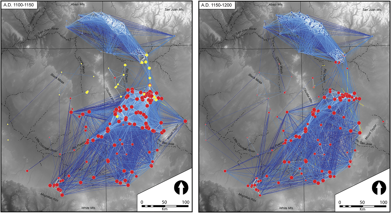
Figure 8 Chaco great house and great kiva networks. Left: AD 1100–1150; right: AD 1150–1200 (figure by Matthew Peeples).
Conclusions
We conducted dynamic SNA at 50-year intervals spanning 400 years across the Chaco World in order to evaluate several migration scenarios. This regional analysis utilises the largest database of ceramics yet compiled from Chaco great houses and great kivas, and the only one to apply a consistent, quantitative method so as to establish chronological control and determine the strength of ties between sites. Reconstructing social networks using ceramic similarities is based on the accumulation of consumption decisions, or the choices made about which vessels to use for cooking, serving and storage—including local and imported products. We supplement our painted ware network analysis with complementary evidence using the technological attribute of smudging. Smudging is primarily found on the interior of unpainted red and brown bowls, including unusual forms that may have been used within a restricted community of religious specialists.
Our results indicate strong, early connections among Southern San Juan settlements, including those in Chaco Canyon, but a prominent gap in relations between the Southern and Northern San Juan until the eleventh century AD. We find little evidence that Chaco’s origins in the AD 800s corresponded to a migration out of the Northern San Juan. There is much greater support for migration from the south and west and continued connections to these areas through the twelfth century. There is also a distinctive connectivity gap defined by the San Juan River until the eleventh century. The establishment of ties across this gap via Aztec Ruins and neighbouring sites in the late AD 1000s and 1100s supported bi-directional migration between Chaco Canyon and the Middle and Northern San Juan along the Great North Road. Dynamic network analysis supports some migration scenarios over others, and provides a regional perspective on the historical trajectory of the Chaco World. This case study adds to global studies of migration as a key demographic variable of past societies. The study also supports the use of SNA to evaluate migration hypotheses in the archaeological record.
Supplementary material
To view supplementary material for this article, please visit https://doi.org/10.15184/aqy.2018.86
Acknowledgements
We thank Dennis Gilpin, Winston Hurst, Paul Reed and Lori Reed for sharing ceramic data. We also thank the staff of the institutions that provided access to collections including the American Museum of Natural History, Arizona State Museum, Arizona State University Archaeological Repository, Chaco Culture National Historic Park, Edge of the Cedars Museum, Museum of New Mexico, Museum of Northern Arizona, Salmon Ruins Museum, School for Advanced Research and the Navajo Nation. Financial support was provided by NSF Awards #1355374 (Mills) and #1355381 (Clark). Our thanks also go to the external reviewers for their helpful comments.

