Introduction
In the early first millennium BC, the Late Bronze Age communities of southern Iberia occupied hilltop settlements that were often fortified. Their houses were sometimes large, frequently oval in plan and made from perishable materials; some had stone foundations. These communities were probably not organised along state-based lines; instead kinship played a significant role in these societies (e.g. González Wagner Reference González Wagner, Alvar, Casillas, Myro and Plácido2000), although there is some evidence of ranking, illustrated, for example, by the so-called ‘warrior stelae’ (García Alfonso Reference García Alfonso2007: 385; Berrocal-Rangel & Silva Reference Berrocal-Rangel and Silva2010: 429). These communities produced hand-made ceramics and metal objects, mostly of bronze, being well located to exploit the rich copper sources of the Iberian Pyrite Belt and to participate in the Atlantic tin and gold exchange networks (Iacono et al. Reference Iacono2021). Moreover, southern Iberia was connected to the contemporaneous Mediterranean trade routes. Seafarers from elsewhere in the Mediterranean frequented the area, trading and perhaps even living temporarily amongst the local populations (for a full discussion, see Ruiz-Gálvez Priego Reference Ruiz-Gálvez Priego2013: 278–86), while life went on as usual for the vast majority of Late Bronze Age southern Iberian communities.
In the ninth century BC, Phoenicians from Tyre in the Levant began to settle in the region. By the eighth century BC, they had created a number of ‘colonies’, most notably Gadir in modern Cádiz. Yet the term colony covers a range of situations, not necessarily simply a straightforward implantation of external populations. The Phoenicians were not in a position to simply impose their will on the local southern Iberian communities; the latter were not passive in this process (Delgado Hervás Reference Delgado Hervás and Alonso2008: 377–79) and their consent and support were necessary. The establishment of mutually beneficial relations that culminated in the founding of Phoenician ‘colonies’ in Iberia required time and negotiation, a theme to which we return in our closing discussion. Some transitional stage, characterised by increasing interactions between Indigenous groups and Phoenician newcomers, must have existed before the emergence of Gadir. But what was the nature of such relations? For decades archaeological narratives of this transitional period suffered from a lack of data, but over the past 15 years, important discoveries, especially in the coastal area between Huelva and Málaga (Spain), have illuminated the beginnings of the Phoenician diaspora in the Western Mediterranean, before formal colonies came into being. Here, we synthesise the latest data and assess their significance for understanding the Late Bronze Age and Early Iron Age in the westernmost Mediterranean.
It is worth noting at the outset that the chronology of this period, both traditional and current, relies primarily on cross-dating methods based on typological links between Phoenician and Greek ceramic wares found in the Western Mediterranean, and other, more securely dated, wares found in the Eastern Mediterranean. Until recently, relevant radiocarbon dates were few, and they appeared not to match historical chronologies or typological cross-dating. As a new contribution to this issue, this article includes a statistical analysis of a series of radiocarbon dates from Huelva.
New evidence from the earliest Phoenician settlements in Iberia
Huelva (Spain)
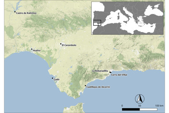
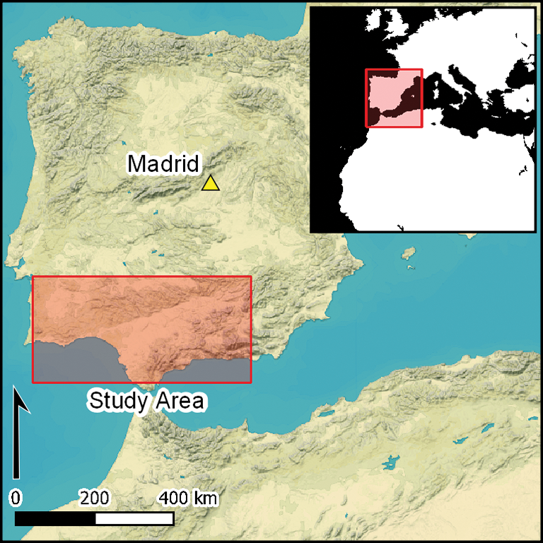
The hinterland of present-day Huelva, located to the west of the Strait of Gibraltar (Figure 1), is rich in mineral and metal resources. Research conducted in the estuary formed by the confluence of the Tinto and Odiel Rivers has yielded data on what might be the earliest evidence for the continued presence of Phoenicians in southern Iberia (González de Canales Reference González de Canales, Gailledrat, Plana Mallart and Dietler2018). In the early first millennium BC, this Atlantic coastal area was characterised by alternating promontories and natural inlets. Some of these hills (cabezos) were frequented by local communities from at least the Late Bronze Age (Gómez Toscano et al. Reference Gómez Toscano, Beltrán Pinzón, González Batanero and Vera Rodríguez2014: 141), although little is known about their settlements.
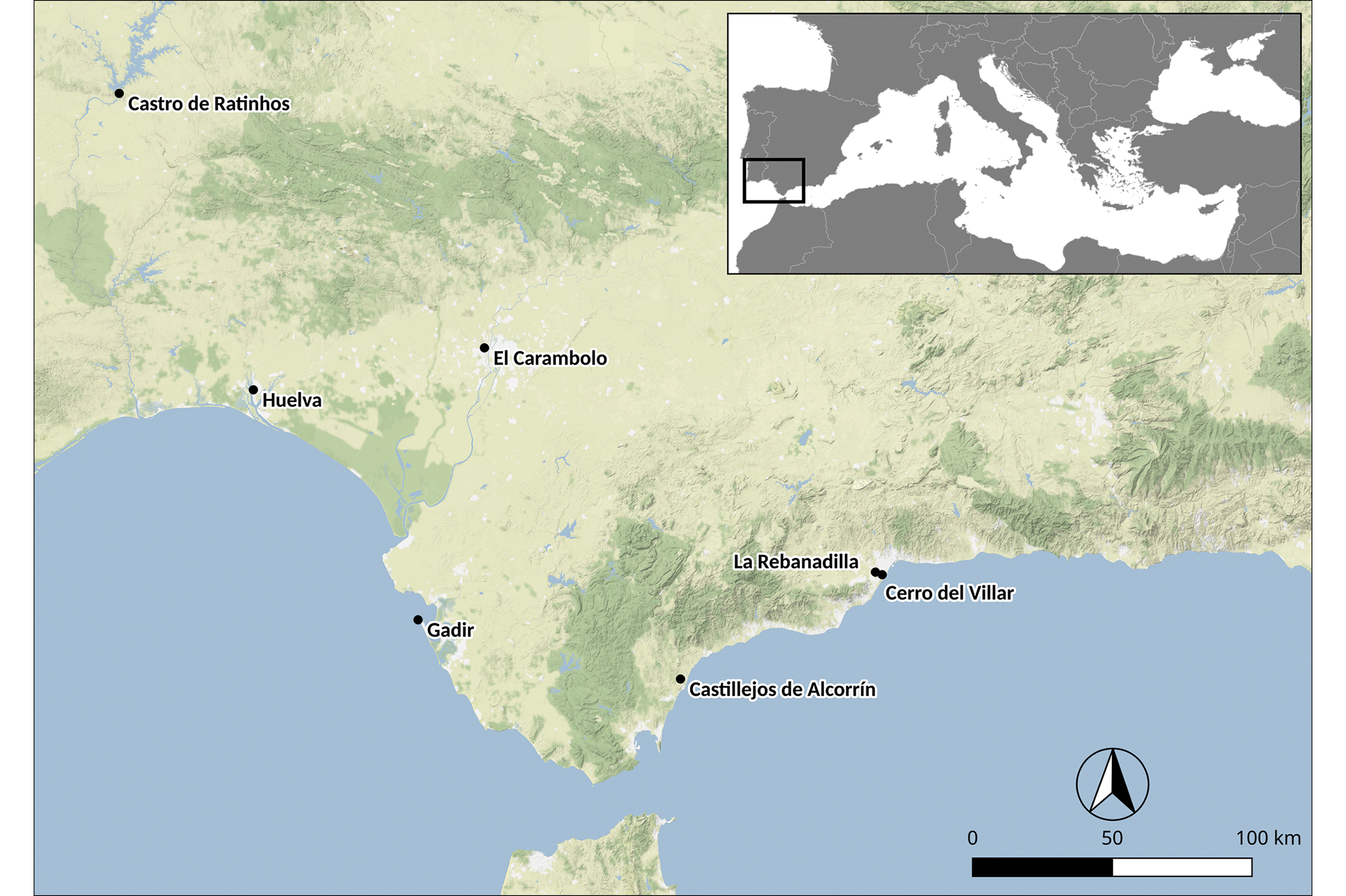
Figure 1. Location of the sites mentioned in the text (map tiles by Stamen Design, under CC BY 3.0.; data by OpenStreetMap, under OdbL).
In the ninth century BC, a settlement was established on the Cabezo de San Pedro (phase 1) in what is now the city of Huelva, itself on a peninsula within the estuary. While this is widely considered to be an Indigenous centre, it nonetheless exhibits clear evidence of contact with the Phoenicians: in its upper part, a wall was constructed using techniques that are consistent with Levantine traditions (González de Canales et al. Reference González de Canales, Serrano Pichardo, Llompart Gómez, Montaño and Botto2018). Moreover, excavations at the sites of Plaza de las Monjas 12, Calle Méndez Núñez 7–13 (González de Canales et al. Reference González de Canales, Serrano Pichardo and Llompart Gómez2004) and Calle Concepción 3 (García Fernández et al. Reference García Fernández2016) have located the lower parts of the settlement, which probably included a port, at the foot of the Cabezo de San Pedro. Thick layers on these sites, perhaps representing rubbish middens, have yielded rich assemblages of finds. These include locally made pottery similar in proportion to that from San Pedro phase 1, together with eastern Phoenician ceramics, and, to a lesser extent, fragments of wares of Cypriot, Sardinian, Attic Greek (Middle Geometric II, c. 850–800 BC; García Alfonso Reference García Alfonso2016), Euboean-Cycladic and Villanovan origin. The presence of foreign craftspeople in the area is suggested by the earliest-known evidence of iron and silver metalworking in Iberia (Murillo-Barroso et al. Reference Murillo-Barroso2016) and Phoenician graffiti on ceramics. A set of lead weights based on the Phoenician shekel (a metric system) (González de Canales et al. Reference González de Canales, Serrano Pichardo and Llompart Gómez2004: pl. LXIV & 21–24) indicates trade activities (Aubet Reference Aubet2012: 232). Common grape (Vitis vinifera) seeds have been recorded on these three sites (Pérez-Jordà et al. Reference Pérez-Jordà, Peña-Chocarro, García Fernández and Vera Rodríguez2017), and cultivation trenches suggestive of viticulture have been identified 3km to the north-east at the site of La Orden-Seminario (González de Canales et al. Reference González de Canales, Montano and Llompart2020).
Castro de Ratinhos (Moura, Portugal)
Castro de Ratinhos (Berrocal-Rangel & Silva Reference Berrocal-Rangel and Silva2010; Berrocal-Rangel et al. Reference Berrocal-Rangel, Silva, Prados Martínez and Jiménez Avila2012) is an Indigenous Late Bronze Age fortified settlement located on a promontory overlooking a natural ford of the River Guadiana (Figure 1). Excavations here have revealed an acropolis enclosed by an inner wall and a small outer ditch. The earliest houses were large and oval, with narrow bases made of stone slabs that were embedded vertically in the ground (phase 2, thirteenth to ninth centuries BC). In this part of the settlement, these houses were scattered, with no apparent spatial order, and succeeded one another in four superimposed levels.
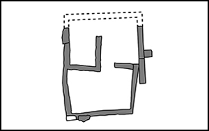
During phase 1b (ninth century BC), the internal spatial organisation of the site remained fundamentally unchanged, although certain foreign practices were adopted. In the upper part of the settlement, new, large houses were built over the remains of the earlier ones. These new houses had perfectly circular plans, with a radius in keeping with ‘Ezekiel's cubit’ (0.52m), a measurement unit almost certainty introduced by the Phoenicians. Their stone foundations were also built using non-local techniques. Additionally, a ‘special’ building (MN23) was erected at this time (Figure 2A). Its L-shaped ground plan, comprising multiple cells, mimics Levantine models. Liturgical paraphernalia, such as a baetylus (a sacred stone), were found inside (Berrocal-Rangel & Silva Reference Berrocal-Rangel and Silva2010: 188–92). Of particular note are seven carefully buried, small, gold buttons typical of the Atlantic Late Bronze Age, but Eastern Mediterranean techniques, such as filigree, were employed in their manufacture (Berrocal-Rangel & Silva Reference Berrocal-Rangel and Silva2010: 325). The building has been interpreted as a small temple dedicated to Baal and Asherah (Prados Martínez Reference Prados Martínez, Berrocal-Rangel and Silva2010). Even in these times of change, most local craft traditions, such as hand-made pottery and bronze metallurgy, continued.
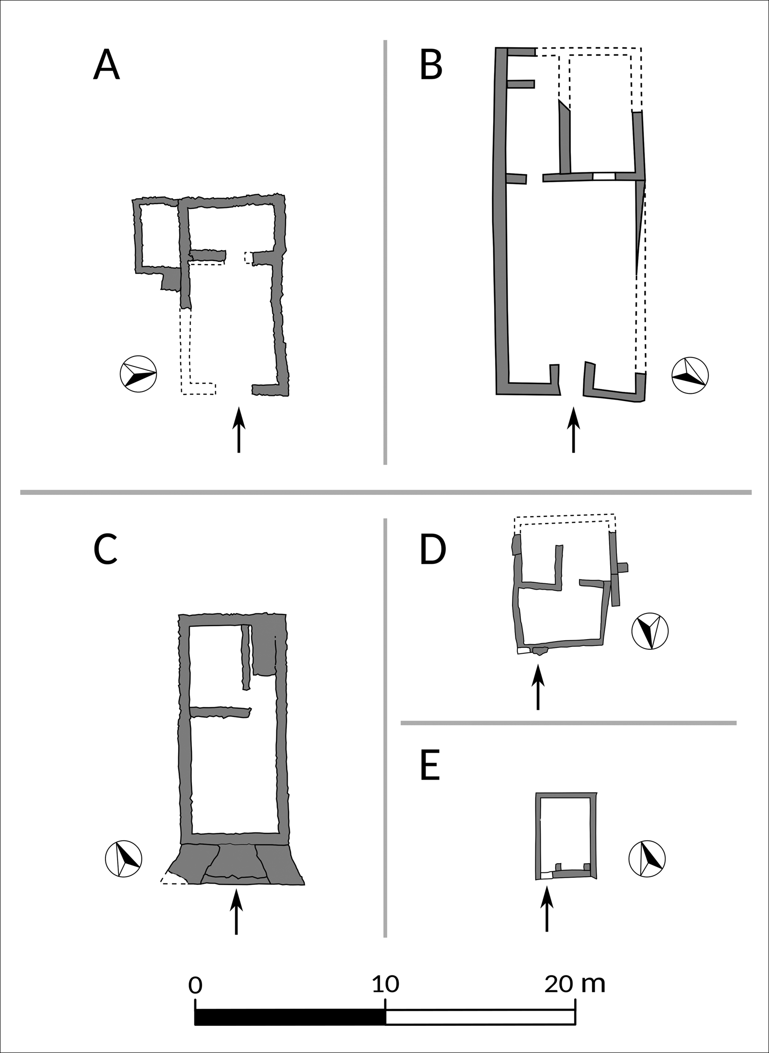
Figure 2. Floor plans of Early Iron Age A rectangular buildings: A) Castro de Ratinhos MN23 (Moura, Portugal) (modified from Berrocal-Rangel et al. Reference Berrocal-Rangel, Silva, Prados Martínez and Jiménez Avila2012: fig. 4.1); B) El Carambolo V (Seville, Spain) (modified from Fernández Flores & Rodríguez Azogue Reference Fernández Flores and Rodríguez Azogue2005: fig. 2); C) Castillejos de Alcorrín Building A (Manilva, Málaga, Spain) (modified from Marzoli et al. Reference Marzoli2010: fig. 6); D–E) La Rebanadilla temple 2 and temple 1 (Málaga, Spain) (modified from Sánchez Sánchez-Moreno et al. Reference Sánchez Sánchez-Moreno and Botto2018: figs 3–4).
Sometime around the mid eighth century BC the buildings and the enclosing wall were destroyed or repurposed. New houses of Indigenous style and construction technique, reminiscent of those from phase 2 of the settlement, were built in their place (phase 1a).
El Carambolo (Camas, Seville, Spain)
At the beginning of the first millennium BC the mouth of the River Guadalquivir formed a wide, navigable estuary that extended inland for tens of kilometres. There, the site of El Carambolo occupies a promontory near the modern city of Seville, close to natural paths that led to the rich mining region of Aznalcóllar (Figure 1; Fernández Flores & Rodríguez Azogue Reference Fernández Flores and Rodríguez Azogue2005, Reference Fernández Flores, Rodríguez Azogue, de la Bandera Romero and Albelda2010; Escacena Carrasco et al. Reference Escacena Carrasco, Fernández Flores and Rodríguez Azogue2007).
In the Late Bronze Age several pits at the site were dug and perhaps ritually backfilled; locally produced, handmade wares dominated their assemblages. Radiocarbon-dating suggests that this activity took place sometime between the fourteenth and the twelfth centuries BC. Later, in the late ninth and early eighth centuries BC (based on ceramic typology), a mud-brick building was erected on the upper part of the hill (Figure 2B). This building is interpreted as a Phoenician temple or sanctuary (Fernández Flores et al. Reference Fernández Flores, Casado Ariza, Prados Pérez and López Castro2020), perhaps dedicated to Astarte, as suggested by the nearby presence of a bronze statuette of Astarte with a Phoenician inscription on its base, and the existence of seashell floors. Such floors are often considered indicative of Phoenician influence, as they first appeared in coastal areas of the Levant in the second millennium BC. In the Eastern Mediterranean their presence is commonly associated with cultic contexts, as they appear to have had an apotropaic character. This has informed the interpretation of analogous phenomena in the Western Mediterranean (Escacena Carrasco & Vázquez Boza Reference Escacena Carrasco and Vázquez Boza2009). Originally (Carambolo phase V), and in typical Levantine fashion, the building's floor plan was rectangular, with a courtyard surrounded by a continuous bench, and two rear cellars. An altar was erected inside one of these spaces. Associated ceramics and other materials are overwhelmingly local in origin.
Castillejos de Alcorrín (Spain)
Although much remains unknown about the Late Bronze Age in the Guadiaro region to the east of the Strait of Gibraltar (Figure 1), we do know that it was populated in the Late Bronze Age, and that foreign artefacts reached the area in the early first millennium BC (Marzoli et al. Reference Marzoli, Padilla and Ortiz2014). Various points along the coast must have provided convenient stopping places for ships on their way to the Atlantic Ocean.
In the late ninth century BC a massive fortified settlement was built at Los Castillejos de Alcorrín (Manilva, Málaga), approximately 7km from the mouth of the Guadiaro River (Marzoli et al. Reference Marzoli2010, Reference Marzoli, Suárez-Padilla and Martín2020a). The external rampart is more than 2km long and encloses an area of 11.3ha. The wall was reinforced with semi-circular towers at its weakest points. In addition, recent geophysical surveys and excavations have revealed an internal rampart comprising an outer ditch and an inner wall, which delimit an ‘acropolis’. Various scattered buildings have been found within, including a large ellipsoidal structure constructed in the local Late Bronze Age style (building C). By contrast, other buildings have a clear Levantine-influenced appearance. Building A, for example, is a rectangular structure with a trapezoidal porch paved with seashells, as well as a courtyard and two rear rooms (Figure 2C). Excavation of building A yielded almost no finds. Evidence of iron working involving ores extracted from nearby mines was recovered at Alcorrín (Marzoli et al. Reference Marzoli, Padilla and Ortiz2014; Renzi et al. Reference Renzi, Bode and Marzoli2016). In the eighth century BC the rectangular buildings were enlarged and remodelled (phase 2). Their assemblages, particularly the ceramics, continued to be predominantly local, with rare fragments of western Phoenician wares. Alcorrín was finally abandoned towards the end of the eighth century BC (Marzoli et al. Reference Marzoli and López Castro2020b).
The bay of Málaga
The bay of Málaga lies some 100km east of the Strait of Gibraltar. Two major ancient watercourses flowed into the sea here: the Guadalhorce, which formed a wide estuary that is now almost completely silted up, and the Guadalmedina, around which the modern city of Málaga is situated.
Although Late Bronze Age settlements are not well known in this area, a Phoenician presence is visible from the second half of the ninth century BC onwards. Excavations at the site of La Rebanadilla (Sánchez Sánchez-Moreno et al. Reference Sánchez Sánchez-Moreno and Domínguez Pérez2011, Reference Sánchez Sánchez-Moreno and Alfonso2012, Reference Sánchez Sánchez-Moreno and Botto2018) on an islet in the Guadalhorce estuary have revealed a series of scattered pits containing the remains of metalworking and Indigenous pottery (Rebanadilla phase IV). One pit contained various exotic items, including fragments of Levantine fine ware and other red-slipped pottery, and of Sardinian and Greek vases, including two Middle Geometric II skyphoi (García Alfonso Reference García Alfonso2016: 125). Shortly thereafter, but still within the second half of the ninth century BC, La Rebanadilla witnessed considerable changes (phase III), including the construction of a rammed-earth enclosure delimiting an area of around 2ha. This space enclosed a series of rectangular buildings separated by streets. Outstanding amongst these is building 5 (or temple 2; Figure 2D), a rectangular structure within which various ritual items have been found, such as a baetylus and a red-slipped thymiaterion (incense burner). Building 4 (or temple 1) consists of a single large room with an altar (Figure 2E). La Rebanadilla III has also yielded a series of graffiti, some of which appear votive in character, with one possibly mentioning the Phoenician god Eshmun. Hence, La Rebanadilla III is considered a ritual area (Sánchez Sánchez-Moreno et al. Reference Sánchez Sánchez-Moreno and Botto2018).
In 770–760 BC, the Phoenicians founded Cerro del Villar, one of the largest ‘colonies’ in southern Iberia, on an island in the delta close to the mouth of the Guadalhorce (Aubet Reference Aubet, López-Ruiz and Doak2019: 82). Around that time the ritual area at La Rebanadilla was abandoned and superseded by newly built huts with oval plans (phase I).
Dating the establishment of the ‘Phoenician quarter’ at Huelva
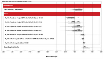
The data presented above suggest that the Phoenicians first settled in southern Iberia at Huelva, although they were perhaps also present at Ratinhos (phase 1b), El Carambolo (phase V), Alcorrín (phase 1) and La Rebanadilla (phases IV–III). Archaeologists have identified the ninth century BC as the most likely date for these Phoenician settlement events, based on ceramic typologies. Some argue that this process started in the first half of the ninth century (e.g. González de Canales et al. Reference González de Canales, Serrano Pichardo and Llompart Gómez2004, Reference González de Canales, Serrano Pichardo, Llompart Gómez, Montaño and Botto2018; Mederos Martín Reference Mederos Martín2006), but most suggest the second half of the ninth century (Gilboa Reference Gilboa, Campos Carrasco and Ezquerra2013; García Alfonso Reference García Alfonso2016; Núñez Reference Núñez and Botto2018; Aubet Reference Aubet, López-Ruiz and Doak2019). Here we present a Bayesian analysis of a series of recently published radiocarbon dates from various contexts at Huelva (Table 1). We were particularly interested in determining the start and end dates for the earliest stages of the Phoenician presence at Huelva, and comparing them with chronologies based on ceramic typologies. Although there is some discussion about the specific stratigraphic contexts from which some of these samples were taken, all are indisputably associated with ninth-century BC Mediterranean ceramics. We used OxCal v4.3.2 (Bronk Ramsey Reference Bronk Ramsey2017) and the IntCal13 atmospheric curve (Reimer et al. Reference Reimer2013), and applied a TAU approach to mitigate the plateau affecting the older dates in our dataset.
Table 1. Radiocarbon dates from Huelva subject to statistical Bayesian analysis (dates calibrated with OxCal v4.3.2, using the IntCal13 atmospheric curve (Reimer et al. Reference Reimer2013; Bronk Ramsey Reference Bronk Ramsey2017)).
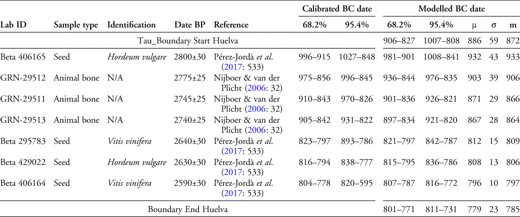
The results, supported by an Amodel of 102.6 and an Aoveral of 102.3, are revealing (Figure 3). With a 68.2 per cent certainty, our series begins in 906–827 BC (average 886 BC, with a standard deviation of 59 years and a median in 872 BC). It ends, also with a 68.2 per cent certainty, in 801–771 BC (average 779 BC, with a standard deviation of 23 years and a median in 785 BC). We draw two conclusions from this. First, the modelled dates match the expected chronological range of the associated ceramics. Second, both lines of evidence appear to confirm that the Phoenician quarter at Huelva was established in the ninth century BC, probably in its second half.

Figure 3. Bayesian analysis of the radiocarbon dates from Huelva included in Table 1 (dates calibrated with OxCal v4.3.2, using the IntCal13 atmospheric curve (Reimer et al. Reference Reimer2013; Bronk Ramsey Reference Bronk Ramsey2017)) (figure by the authors).
Discussion
In the mid to late ninth century BC, King Ithobaal of Tyre initiated an expansionist commercial policy. Ancient texts describe the deals agreed with foreign officials to establish Phoenician ‘districts’ or ‘quarters’ in non-Phoenician settlements (Aubet Reference Aubet2012). There, Phoenician merchants settled and traded, often paying tributes or taxes to the local authorities. Such deals were often put under the protection of divine powers, thus requiring the construction of temples. Examples of Phoenician commercial districts include Samaria in the Levant and Kommos in Crete. Soon, Phoenicians spread farther westward, probably in search of metals (Aubet Reference Aubet, López-Ruiz and Doak2019: 75–77).
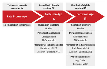
This Phoenician diaspora marks the onset of what we call the Early Iron Age A in southern Iberia (Figure 4). At this time, Indigenous groups began to show more interest in coastal areas than previously (Aubet Reference Aubet, López-Ruiz and Doak2019: 80). The archaeological data presented here show a diversity of forms of interaction between local people and newcomers. Phoenician ‘quarters’, of which Huelva is the most likely example, represent one form of such interaction: Phoenician traders probably settled in the lower town at Huelva under the protection of the local authorities, while the local population occupied the Cabezo de San Pedro (Aubet Reference Aubet2012: 232). Sanctuaries located in a neutral or peripheral area constitute another type of evidence. Such sites probably included at least one temple and several ancillary structures for accommodation and various economic activities. They most likely functioned as marketplaces, where newcomers and local populations met. Thus, they cannot simply be considered as ritual spaces, but also as small economic centres and gathering places. La Rebanadilla and El Carambolo appear to fit this description (Delgado Hervás Reference Delgado Hervás and Alfonso2014: 284–86). The Levantine-style ‘temple’ built within an Indigenous settlement at Ratinhos MN23, and perhaps Alcorrín Building A, represent a third category.

Figure 4. Diagram summarising the chronology of the earliest Phoenician presence in southern Iberia, with examples (figure by the authors).
Cultural practices combining features of both Eastern and Western traditions began to appear in the late ninth century, such as the new building techniques recorded at Ratinhos. It is difficult to know how many Phoenicians visited those places, or for how long, but Levantine artisans must have been present, working for local leaders. None of this implies Phoenician political control over lands or pre-existing Indigenous groups. Rather, it seems reasonable to suggest that the attitude of local populations towards the Levantine incomers was the deciding factor between the alternative approaches represented by the types of sites outlined above. For the same reasons, the speed of the process may have also varied between each local area.
The transition from the ninth to the eighth century saw important changes in settlement patterns in the region. Principal among them was the foundation of several Phoenician ‘colonies’. In Iberia these ‘colonies’ are essentially a phenomenon dating from the eighth century BC onwards. In our view, their emergence marks the beginning of a new period, which we call the Early Iron Age B (eighth century BC) (see also López Castro Reference López Castro, López-Ruiz and Doak2019). There is some chronological overlap between this period and the Early Iron Age A: recent fieldwork and material typologies have shown that Gadir (present-day Cádiz), the earliest Phoenician settlement of ‘colony’ type in the region, was first occupied in the closing years of the ninth century (Torres Ortiz et al. Reference Torres Ortiz and Botto2014). Furthermore, some Early Iron Age A settlements and buildings persisted into the eighth century BC (see below). Yet even the earliest ‘colony’ at Gadir clearly post-dates the Phoenician ‘quarter’ at Huelva. Moreover, these colonies are conceptually very different from previous Phoenician settlements in the area.
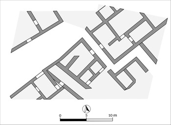
Formal colonies usually occupied favourable coastal harbour locations, such as promontories or islets near the mouth of a river. Their establishment entailed the arrival of a considerable number of Levantine migrants, as reflected in their material culture, mortuary practices, ritual and ideology (Aubet Reference Aubet, Riva and Vella2006: 94–95). It is likely that colonies proper, unlike Phoenician ‘quarters’, exerted political control over a territory, including satellite settlements, which gave them access to a wider array of resources. Some colonies were true urban centres, such as Gadir and perhaps Cerro del Villar (Gener Ballasote et al. Reference Gener Ballasote and Botto2014; Aubet Reference Aubet, López-Ruiz and Doak2019). The former had residential areas, with large houses presumably occupied by wealthy merchants (Figure 5). Furthermore, at Gadir, following an initial period in which imported eastern Phoenician wares dominate archaeological assemblages, newly created ceramic workshops began to produce wares in a distinctive western Phoenician style.

Figure 5. Plan showing the urban character of the ‘Teatro Cómico’ area at Gadir (Early Iron Age B period) (modified from Gener Ballasote et al. Reference Gener Ballasote and Botto2014: fig. 25).
Readers will have noticed that quotation marks have been added to the term colony in many instances. That is because post-colonial research has shown that the concept of colony is not straightforward (e.g. van Dommelen Reference van Dommelen1997; Dietler & López-Ruiz Reference Dietler, López-Ruiz, Dietler and López Ruiz2009: viii; Marín Aguilera Reference Marín Aguilera2012). If taken uncritically, one may think that the ‘colonies’ mentioned were exclusively a Phoenician project, and that their existence reflects the political supremacy of Tyre over Indigenous groups. The acquiescence of local communities and political agreements between both parties, however, were necessary preconditions for their creation. The ‘colony’ at Cerro del Villar, for example, could not have survived without a continuous supply of basic agricultural goods from surrounding communities (Aubet Reference Aubet, López-Ruiz and Doak2019: 82). Local people and newcomers surely lived together, or alongside each other, in these ‘colonies’, as attested by the ceramic assemblages from the earliest deposits at Gadir, which are dominated by Indigenous wares (up to 60–70 per cent) (Torres Ortiz et al. Reference Torres Ortiz and Botto2014: 51). Certainly, ‘colonies’ served as the backdrop for the emergence of new social identities and hybrid materialities (Delgado Hervás Reference Delgado Hervás and Alfonso2014: 284).
What happened to the Early Iron Age A sites of southern Iberia? The sanctuary at El Carambolo remained in use for an extended period, probably as a Phoenician sanctuary within a broadly local Iron Age context. By contrast, Alcorrín was abandoned before the end of the eighth century, and Ratinhos MN23 was violently destroyed in c. 750 BC. Perhaps these sites were no longer necessary, but it is also possible that some local communities rejected the new state of affairs and rebelled against it. In this regard, it is worth noting that the abandonment of the temples at La Rebanadilla in the eighth century BC roughly coincided with the foundation of the nearby Cerro del Villar Phoenician ‘colony’. It is currently unclear for how long the Phoenician ‘quarter’ at Huelva survived, or whether it evolved into something else.
Conclusions
Our synthesis of new evidence shows that, at least in the westernmost Mediterranean, Phoenician ‘colonies’ of the eighth century BC were preceded, in the ninth century, by a presence of Phoenicians in a range of contexts and sites that were not under their political control. Some were perhaps Phoenician districts associated with Indigenous centres, within which Levantine merchants settled on a permanent basis. Other sites, such as sanctuaries located in peripheral areas or Indigenous settlements where Phoenician craftsmen worked, must have experienced a more sporadic or intermittent Phoenician presence. Taken together, they represent the materialisation of complex processes of interaction and negotiation between Phoenicians, led by Tyre, and southern Iberian communities. Relevant data are still scarce and uncertainties remain, leading to our tentative conclusions, which, we hope, will be tested by future investigations. Such research is not only key for understanding the integration of the Phoenicians into southern Iberia, but is of wider significance for apprehending the mechanisms of colonisation and pre-colonial situations elsewhere in protohistoric Europe and in other contexts around the world (Dietler Reference Dietler2010).
Acknowledgements
We are grateful to the research team investigating the site of Los Castillejos de Alcorrín, coordinated by Dirce Marzoli, Director of the German Archaeological Institute in Madrid. M.E. Aubet supported us and helped us to understand this complex period better. We also thank the two anonymous peer reviewers for their work on this article.
Funding statement
This research received no specific grant from any funding agency or from commercial and not-for-profit sectors.
Supplementary material
To view supplementary material for this article, please visit https://doi.org/10.15184/aqy.2021.105


