


Introduction
The Kastro peninsula (38°52′29′′N, 23°03′19′′E) constitutes the extension towards the West of Myrina, the Lemnos capital, on the western coast of the island, in the North Aegean Sea. The hilly Kastro headland consists of volcanic rocks, mainly dacites (Anonymous 1993; Fornadel et al. Reference Fornadel, Voudouris, Spry and Melfos2012, 89; Pe-Piper et al. Reference Pe-Piper, Piper, Koukouvelas, Dolansky and Kokkalas2009, 41) and attends up to approximately 116 meters (Admiralty Chart 1998 , nr. 1636) above present sea level (Figure 1). The headland took its name from the Byzantine, Venetian, Genovese and Ottoman castle (“Kastro”) on its northern, highest part. The castle structures, edifices and triple enclosure were built and periodically restored from the 12c. AD onwards (Hellenic Ministry of Culture 1999, 56–57). Before Medieval and post-Medieval occupation, the rocks had been carved in several areas, creating anthropogenic structures, engravings and complexes within the natural landscape and seascape (Marangou Reference Marangou2009; Reference Marangou, Spasova and Genov2020b; Reference Marangou2021) (Figure 2a). Due to polychromatic and morphological particularities, as well as to erosion and ulterior damage, it may be arduous to distinguish anthropogenic alterations from the natural rock. If rock-cut features and rock art are omnipresent on the whole peninsula, including inside the castle walls and on the outskirts of the town, they are better preserved in areas that were less densely re-occupied. In all attested periods, the maritime connections of the Kastro rock-cut features and rock art are obvious, suggested not only by its close associations to the coast and the sea, but also by residues of seashells and materials arrived by sea, as well as by nautical representations (Marangou Reference Marangou2006, Reference Marangou, Spasova and Genov2020b, Reference Marangou2021) (Figure 2b).

Figure 1. General view of the Myrina Kastro peninsula from the East. The ellipse shows the location of the sampling site. (photograph C. Marangou).

Figure 2. (a) Rock-cut features of Kastro: flights of steps, channel, cavity, remains of vertical “panels/walls”. (b) Rock-art on Kastro: the rock-engraving of a rowed ship, probably dating from the Bronze Age, on the vertical surface of a rock-cut, stepped feature in the Myrina port (photographs C. Marangou).
The ongoing research on rock-cut features and rock-art on Myrina Kastro is realized with the permission of the Greek Archaeological Service, the Local Council for the Monuments of the Islands and the Greek Ministry of Culture. In addition to the study of rock-cut structures and rock-art on the surface, the research project at Kastro included, during the years 2002–2007, a sub-surface investigation related to a number of selected rock-cut features, which permitted the collection of mobile finds, including organic materials, such as charcoal and seashellsFootnote 1 . The samples examined in this paper were found in the exterior of the castle fortification walls, in southern and eastern Kastro areas. The charcoal samples were found in four sectors of the peninsula, two of which provided the largest part, while two sea-shells were connected to charcoal samples in one of the latter sectors.
The present paper has two objectives, the first one is the radiocarbon dating with AMS of the investigated deposits, obviously associated to the aforementioned rock-cut features, and the second one the calculation of the regional marine reservoir effect in the Late Bronze Age in the Aegean Sea. The latter is part of a large-scale project, which is currently underway, to model the global sea-level rise within the Aegean Sea since the Last Glacial Maximum. The results of this project, when it will be completed, may shed light on the complex interaction between sea-level rise, ocean currents and the mixing of Mediterranean, Aegean and Black Seas’ waters. This is done by calculating the marine reservoir effect R(t), as well as the regional sea surface reservoir deviation ΔR from the global ocean model (Stuiver and Braziunas Reference Stuiver and Braziunas1993), in various regions of the Aegean Sea, as it was found that this fluctuates considerably through time (Facorellis and Vardala-Theodorou Reference Facorellis and Vardala-Theodorou2015). The calculation of ΔR in every region is very important, as it allows the: (1) reliable calibration of the conventional 14C ages of marine samples (e.g. marine mollusk shells), in the absence of other suitable material from an excavated site (as they are usually short-lived samples, rarely transported over long distances), (2) reliable calibration of 14C ages of human bones in case of mixed (marine and terrestrial) diet (Sveinbjörnsdóttir et al. Reference Sveinbjörnsdóttir, Heinemeier, Arneborg, Lynnerup, Ólafsson and Zoëga2010), and (3) obtaining of paleoceanographic information (Siani et al. Reference Siani, Paterne, Michel, Sulpizio, Sbrana, Arnold and Haddad2001). The Kastro research offered the opportunity to provide suitable material for such a parallel study and its results are presented together with the archaeological ones.
Materials
During a five-year period (2002–2007) of subsurface investigation campaigns, among other mobile finds, numerous charcoal and seashell samples were collected. The ellipse in Figure 1 shows the location of the sampling site on the Myrina Kastro hill. In this study, the AMS dates of 19 samples (17 charcoal pieces and 2 seashells) are presented.
All charcoal pieces were taken from carbonized wood. Their species have been identified by an anthracological study of the carbonized material unearthed (Table 1). The charcoal samples Lyon-17628(GrM) and Lyon-17627(GrM) were identified as Angiosperms. The taxon Angiosperm includes charred wood remains that present anatomy features of the xylem of the flowering plants, but in the case of the aforementioned samples, their identification to family, genus or species level was not feasible due to bad preservation. The 14C ages obtained for the species Quercus sp. deciduous and Olea europaea can be older due the “old wood effect”. In order to compensate for this potential effect, an approximate correction to the charcoal dates of the aforementioned long-lived species was applied by subtracting 100 ± 50 14C yrs from the 14C ages. For instance, ± 50 yrs were added in quadrature to the measured uncertainty of ± 30 yrs of their 14C ages. Therefore, for the 14C ages of the samples Lyon-17629(GrM), Lyon-19724(GrM), Lyon-16562(GrM), Lyon-16561(GrM), Lyon-19722(GrM), Lyon-16563(GrM), Lyon-16564(GrM), Lyon-19721(GrM), Lyon-19723(GrM) and Lyon-16567(GrM), an increased uncertainty of ± 58.3 yrs (rounded to 60 yrs) was used for their calibration (Table 1).
Table 1. Summary of the AMS radiocarbon dating results of the samples from the Myrina Kastro (subsurface research 2002–2007), Lemnos sorted by increasing age. (msl = mean sea level). (Numbered strata refer to investigated horizontally or/and vertically distinct deposit units)
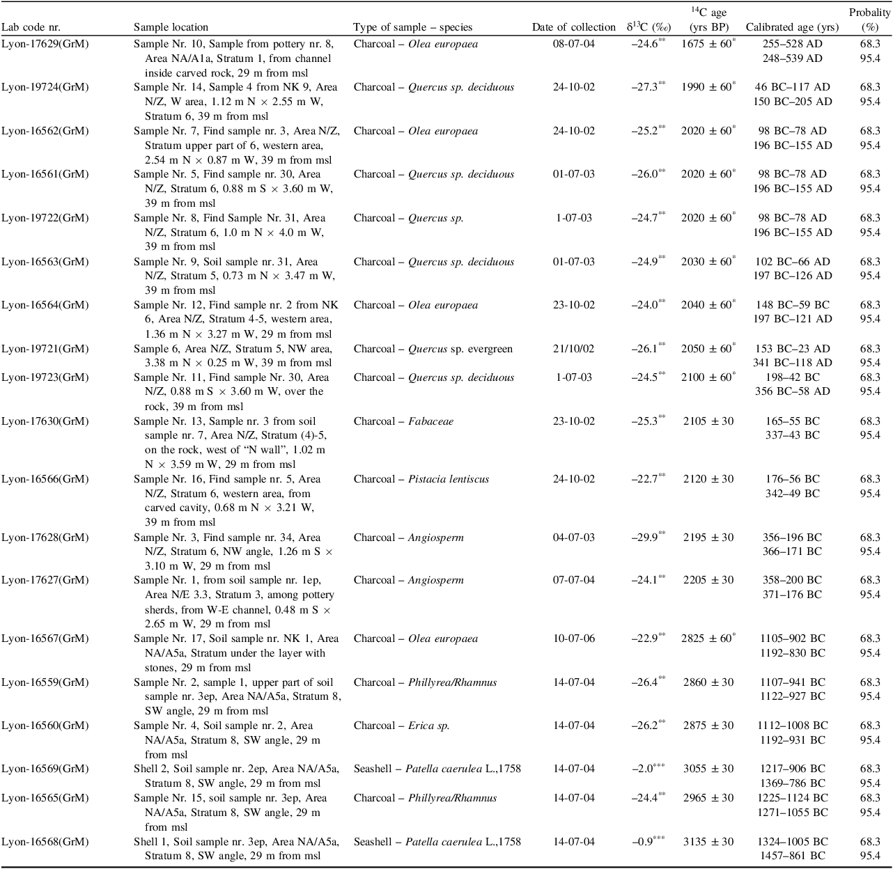
* “Old wood” corrected 14C ages with the subtraction of 100 ± 50 yrs from the measured ones (see text).
** AMS measured value.
*** IRMS measured value.
The charcoal/seashell pairs of samples [Lyon-16565(GrM)/Lyon-16568(GrM) and Lyon-16560(GrM)/Lyon-16569(GrM)] were named Myrina-1 and Myrina-2 (Table 2), respectively. Both samples of each pair were collected exactly in the same location and depth (Table 1) from undisturbed anthropogenic deposits, thus ensuring that all pairs of samples were deposited simultaneously in the past. However, these two pairs were found in slightly different locations and depths at the SW angle and stratum 8 of the area NA/A5a.
Table 2. Regional marine reservoir effect R(t) and local deviation ΔR values for Myrina-1a, Myrina-1b and Myrina-2 charcoal/seashell pairs from the Myrina Kastro, Lemnos
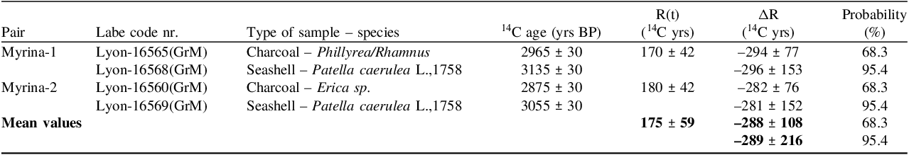
The charcoal sample of the Myrina-1 pair belong to the short-lived tree species Phillyrea/Rhamnus, whereas the one of Myrina-2 pair belong to the short-lived tree species Erica sp.
The seashells of both pairs belong to the species Patella caerulea L.,1758, which is a short-living grazing gastropod species that inhabits the midlittoral and upper intralittoral coastal zones. They have a limited spatial mobility, thus after moving around to graze, they return to their original habitat zone. Though they withstand exposure to wave action, they mainly colonize sheltered areas (Banister Reference Bannister1975; Davies Reference Davies1969; Seila Reference Seila, Robotti and Biglione1993).
Methods
All samples were chemically pretreated in the Centre de Datation par le RadioCarbone in Lyon, France, and graphitized (Aerts-Bijma Reference Aerts-Bijma, Meijer and van der Plicht1997) and measured in the radiocarbon dating facility of the Centre for Isotope Research (CIO) in Groningen, Netherlands (van der Plicht Reference van der Plicht, Wijma, Aerts, Pertuisot and Meijer2000; Wijma Reference Wijma and van der Plicht1997).
The usual acid-base-acid (ABA) protocol was applied for the chemical pretreatment of the charcoal samples. According to this protocol, the samples are roughly crushed before being treated with 2N HCl (room temperature, 1 hr then 4 hr at 95°C), followed by 0.1N NaOH (room temperature, 1 hr then 1 hr at 95°C), and then treated with 2N HCl (room temperature, 1 hr). The samples are washed 3 times with ultrapure MilliQ™ deionized water after each treatment.
After pretreatment, the charcoal samples are combusted in an automated Thermo Finnigan Flash EA 1112 (EA). The EA consists of a Cr2O3 combustion tube, a cobaltous/ic oxide silvered purification furnace, a Cu reduction tube, and a water trap. The EA system is expended with an automatic cryogenic trapping device. This system consists of 16 separate freeze fingers in a vacuum system. Each trap has a pneumatic valve and a Dewar vessel filled with liquid nitrogen. The CO2 of each sample is collected cryogenically in a glass ampoule and sealed.
The treatment of the seashell samples involved a surface cleaning by air abrasion with aluminium oxide powder to remove the outer surface and rinsing with ultrapure water. Then the seashells were etched with aqua regia (0.5–1.0N HCl and HNO3, 3:1) until 10–30% of the sample has been removed to eliminate the surface contaminants (Goslar and Pazdur Reference Goslar and Pazdur1985). The samples were then dried and roughly crushed (Hedges Reference Hedges, Law, Bronk and Housley1989). Afterwards, the samples were reacted with H3PO4 (3 mL, 85%) under vacuum in a two-armed Pyrex reaction vessel. The reaction vessels were transferred to a water bath at 60°C and left to equilibrate for an hour to ensure a complete reaction to avoid fractionation effects, before adding the acid to the samples and leaving to react overnight. The CO2 obtained from each sample was transferred to a glass ampoule and sealed (Facorellis et al. Reference Facorellis, Mari and Oberlin2017).
The stable isotopic values (δ13C) of the seashell samples were measured on an isotope ratio mass spectrometer (IRMS) at the Institut des Sciences Analytiques (ISA) in Lyon, France, whereas those of the charcoal samples were measured by AMS in CIO (Table 1).
Results and Discussion
I. Calculation of the Regional Marine Reservoir Effect
The regional marine reservoir effect R(t) value of each pair is calculated by subtracting the 14C conventional age of the charcoal sample from that of the marine mollusk sample (Facorellis and Vardala-Theodorou Reference Facorellis and Vardala-Theodorou2015; Siani et al. Reference Siani, Paterne, Arnold, Bard, Métivier, Tisnerat and Bassinot2000, Reference Siani, Paterne, Michel, Sulpizio, Sbrana, Arnold and Haddad2001; Stuiver et al. Reference Stuiver, Pearson and Braziunas1986, Reference Stuiver, Reimer and Braziunas1998; Stuiver and Braziunas Reference Stuiver and Braziunas1993). These are R(t) = 170 ± 42 14C yrs for Myrina-1 pair [samples Lyon-16565(GrM) and Lyon-16568(GrM)] and 180 ± 42 14C yrs for Myrina-2 pair [samples Lyon-16560(GrM) and Lyon-16569(GrM)]. The R(t) values of both pairs overlap within 1σ. This consistency thus enables the calculation of a mean R(t) value of 175 ± 59 14C yrs (Table 2). The R(t) and mean R(t) uncertainties were calculated using the following general formula for summing uncertainties:
 $${\sigma _x} = {\rm{\;}}\sqrt {\sigma _1^2 + {\rm{\sigma }}_2^2} $
where x represents R(t) or mean R(t), and σ1 and σ2 are the uncertainties associated with the summed values.
The estimated regional mean R(t) age for the late Bronze Age (from the 13th to the 10th centuries BC) in the Aegean Sea appears to be considerably lower than the modern pre-bomb R(t) age 520 ± 40 14C yrs reported by Siani et al. (Reference Siani, Paterne, Arnold, Bard, Métivier, Tisnerat and Bassinot2000), which was found to be the same with the R(t) age 515 ± 22 14C yrs for the end of the 8th millennium to the beginning of the 7th millennium BC reported by Facorellis et al. (Reference Facorellis, Maniatis and Kromer1998). However, it has been shown that the R(t) ages in the Aegean Sea fluctuate with time (Facorellis and Vardala-Theodorou Reference Facorellis and Vardala-Theodorou2015). Lemnos features a diverse terrain characterized by sedimentary and volcanic rocks. The western part of Limnos, where Myrina Kastro lies, showcases a rugged topography, while the eastern portion is characterized by lower elevations and a smoother landscape (Gläser et al. Reference Gläser, Grosche, Voudouris and Haase2022). However, the Kastro hill consists of volcanic rocks, and its surrounding area between Roméikos Yalos (Greek Coast) and the old port of Myrina consists of sandstone. Additionally, a little further north at Avlona beach, as well as a little further south at Plati bay, there are alluvial and colluvial deposits indicating the action of freshwater (Panagopoulos et al. Reference Panagopoulos, Panagiotaras and Giannoulopoulos2013; Pavlopoulos et al. Reference Pavlopoulos, Fouache, Sidiropoulou, Triantaphyllou, Vouvalidis, Syrides, Gonnet and Greco2013). Nevertheless, the much lower and consistent, within almost 100 years, R(t) ages of both Myrina pairs cannot be attributed to freshwater effects. If this were the case, they would have been much higher due to the incorporation of geological age carbon in the sea mollusk shells. On the contrary, this may be due to a more rapid circulation of the sea surface water. This is probably caused by different sea surface temperatures or sapropel formation conditions (Mercone et al. Reference Mercone, Thomson, Croudace, Siani, Paterne and Troelstra2000; Casford et al. Reference Casford, Rohling, Abu-Zied, Cooke, Fontainer, Leng and Lykousis2002) in the Aegean Sea in the late Bronze Age than those prevailing during the aforementioned time periods.
The ΔR values were calculated with the OxCal v4.4.4 software (Bronk Ramsey Reference Bronk Ramsey2009) employing a Bayesian probability method (Facorellis and Vardala-Theodorou Reference Facorellis and Vardala-Theodorou2015). The routines for these calculations can be found in an appendix in the online version of this paper. For both pairs of samples, the uniform likelihood function U(x1, x2) was set, with x1 = –550 and x2 = 100, to impose constraints on the potential range of ΔR (Bronk Ramsey and Lee Reference Bronk Ramsey and Lee2013). Figure 3 shows the probability distribution plots for (a) the Myrina-1 [Lyon-16565(GrM)— Lyon-16568(GrM)] pair, ΔR = –294 ± 77 14C yrs (within 1σ) and (b) the Myrina-2 [Lyon-16560(GrM)–Lyon-16569(GrM)] pair, ΔR = –282 ± 76 14C yrs (within 1σ) (Oxcal v.4.4.4 Bronk Ramsey Reference Bronk Ramsey2009). Since these values overlap within 1σ, the local mean sea surface reservoir deviation ΔR value calculated from both pairsFootnote 2 is –288 ± 108 14C yrs (Table 2). It is worth noticing that it is the first time that R(t) and ΔR are calculated for the late Bronze Age, thus adding a piece of information on the model of the global sea-level rise within the Aegean Sea.
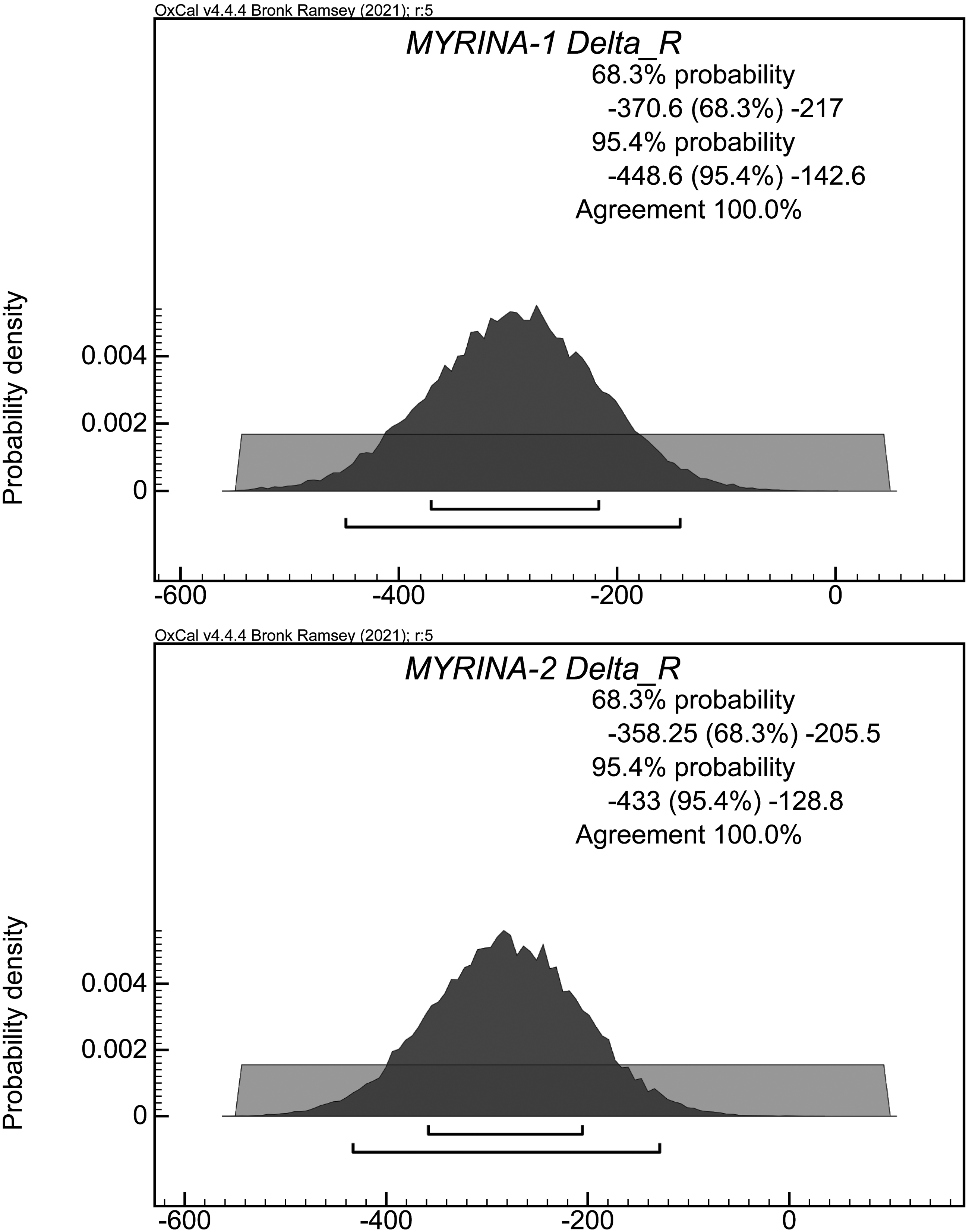
Figure 3. Probability distribution plots for (a) the Myrina-1 [Lyon-16565(GrM)—Lyon-16568(GrM)] pair, ΔR = –294 ± 77 14C yrs (within 1σ) and (b) the Myrina-2 [Lyon-16560(GrM)—Lyon-16569(GrM)] pair, ΔR = –282 ± 76 14C yrs (within 1σ) (Oxcal v.4.4.4 Bronk Ramsey Reference Bronk Ramsey2009).
The conventional 14C ages of the charcoal samples were calibrated with the latest issue IntCal20 of the atmospheric international calibration curve (Reimer et al. Reference Reimer, Austin, Bard, Bayliss, Blackwell, Bronk Ramsey, Butzin, Cheng, Edwards, Friedrich, Grootes, Guilderson, Hajdas, Heaton, Hogg, Hughen, Kromer, Manning, Muscheler, Palmer, Pearson, van der Plicht, Reimer, Richards, Scott, Southon, Turney, Wacker, Adolphi, Büntgen, Capano, Fahrni, Fogtmann-Schulz, Friedrich, Köhler, Kudsk, Miyake, Olsen, Reinig, Sakamoto, Sookdeo and Talamo2020). The 14C ages of the seashell samples were calibrated using the aforementioned mean ΔR value (within 1σ) in conjunction with the latest issue Marine20 of the international marine calibration curve (Heaton et al. Reference Heaton, Köhler, Butzin, Bard, Reimer, Austin, Bronk Ramsey, Grootes, Hughen, Kromer, Reimer, Adkins, Burke, Cook, Olsen, Luke and Skinner2020). All calibrations were also performed with the OxCal v4.4.4 software. Table 1 presents the samples laboratory code, location, species, the obtained 14C and calibrated ages and the corresponding δ13C values sorted by increasing age. The calibrated ages are given using the minimum and maximum for all the probability distribution intervals within 68.3 and 95.4%. At the same time, archaeological data of contexts related to the samples seem to suggest the Late Bronze Age for sector II.1 (NA/A5a), mainly the Hellenistic period, around 300 BC or 3rd century BC for sectors II.2a and II.2b (N/Z and N/E), and Late Antiquity, possibly 4th century AD for sector II.3 (NA/A1a) (see further). However, a table containing all the probability distribution intervals of each calibrated age can also be found online in the appendix. Figure 4 shows the probability distribution plot of the calibrated dates from the Myrina Kastro sorted by increasing age. Black and gray colors indicate calibrated dates obtained from charcoal and seashell samples using the IntCal20 and Marine20 international calibration curves, respectively (Oxcal v.4.4.4 Bronk Ramsey Reference Bronk Ramsey2009).

Figure 4. Probability distribution plots of the calibrated dates from the Myrina Kastro (subsurface research 2002–2007) sorted by increasing age. Black color and gray colors indicate calibrated dates obtained from charcoal and seashell samples using the IntCal20 and Marine20 international calibration curves, respectively (Oxcal v.4.4.4 Bronk Ramsey Reference Bronk Ramsey2009).
II. Rock-Cut Features Connected to the Dated Samples
The samples are all associated to rock-cut features on Myrina Kastro. The current results of the radiocarbon dating seem to confirm that the investigated areas providing the samples were not significantly disturbed by posterior occupation in Medieval and later times, while mobile finds with contextual relations to the analyzed samples are apparently consistent with their 14C dating. According to the current state of research, a part of the mobile finds being still under study, our results show that the investigated subsurface anthropogenic deposits related to selected rock-cut features of the site date from the 13th century BC until the 6th century AD.
II.1 13th–10th centuries BC (Late Bronze Age–Early Iron Age)
On a road side, in front of a stepped dead end
[charcoal samples Lyon-16560(GrM), Lyon-16565(GrM), Lyon-16559(GrM), Lyon-16567(GrM), and seashells Lyon-16568(GrM] and Lyon-16569(GrM)
The earliest dated charcoal samples were collected in a restricted area of up to three square meters. They were found in limited spaces in immediate proximity to or under three vertically set stones forming a rough triangle, the latter located in front of a carved flight of narrow steps ending into the rock without any further issue (Marangou Reference Marangou2020a). Such dead ends, stairs leading nowhere and/or ending to niches, some of them called “stepped altars”, have numerous Bronze Age-Iron Age parallels in Thrace and Anatolia in particular, but also in the Aegean (see references in Marangou Reference Marangou2009, Reference Marangou2020a, Reference Marangou2020b). This restricted space is situated, at the same time, at crossroads, on the side of a rocky passageway, the latter intersected by three different flights of steps; thus both physical and symbolic itineraries would be combined here (Marangou Reference Marangou2020a; Reference Marangou2021). The context of the samples included mainly Late Bronze Age (possibly at least 13th–12th century BC) mobile finds, their dating consistent with that of the samples. Besides fragments of pottery and clay objects, a lot of animal bones and seashells were also found in this areaFootnote 3 , while fragments of figurines and tools mostly related to female activities come from strata slightly later than those of the samples.
A charcoal sample Lyon-16560(GrM) shows a date of 1112–1008 cal BCFootnote 4 . A further charcoal sample Lyon-16565(GrM) coming from a lower level, dates to the Late Bronze Age: 1225–1124 cal BC. The charcoal sample Lyon-16559(GrM): 1107–941 cal BC was found slightly over the sample Lyon-16565(GrM). The context of the sample Lyon-16567(GrM): 1105–902 cal BC, which was not found in connection to the dated shells, comprised organic residues, including a few grains. This sample was related to a group of flat stones horizontally placed, partly located under the vertically set stones, although not necessarily stricto sensu connected to the latter. At the lowest limit of the investigation in this particular spot, it would be slightly later or even contemporaneous to the neighbouring earliest sample (Lyon-16565(GrM).
II.2 4th century BC–1st century AD (mainly Hellenistic, possibly also Late Classical periods)
Most samples but one furnishing dates from approximately the 4th century BC to the 1st century AD come from one of two sectors. As both sectors are rather extended, it is the spaces having furnished the samples that can be dated to these periods, while other zones of one of the areas in particular may also indicate earlier occupation.
II.2.a Carved conduits and cavities, rock-cut “walls” and an open sea-view. [charcoal samples Lyon-19724(GrM), Lyon-17630(GrM), Lyon-16562(GrM), Lyon-16561(GrM), Lyon-16566(GrM)), Lyon-19722(GrM), Lyon-16563(GrM), Lyon-16564(GrM), Lyon-19721(GrM), Lyon-17628(GrM) and Lyon-19723(GrM)]
A large sector with several charcoal samples repeatedly indicates dates spanning from the 4th century BC until the 2nd century AD (356 cal BC–117 cal AD). This extended sector includes carved cavities and conduits, including a large channel, on a rock floor, probably for the management of liquids (Marangou Reference Marangou2006, Reference Marangou2009) and remains of stone wall foundations, as well as a rock “wall” with openings orientated towards the sea and associated to a rock-cut platform with “seats” (Marangou Reference Marangou2006; alleged aniconic “thrones” for divinities: Marangou Reference Marangou, Spasova and Genov2020b with references). These conspicuous rocks could also have constituted a seamark for mariners, offering at the same time a wide-ranging view of the harbour and approaching ships (Marangou Reference Marangou2016; Reference Marangou, Spasova and Genov2020b). Most samples were found in a zone comprising carved conduits and cavities. Comparatively earlier samples were found in a restricted zone, almost immediately over the rock surface. The sector provided various finds (possibly dating from around 300 BC, or the 3rd century BC at the latest). Among others, fragments of pottery and clay objects, such as lamps and tools related to female everyday tasks and female figurines (Marangou Reference Marangou2009, Reference Marangou2016), as well as metal artefacts, including coins and possible residues of metal elaboratioFootnote 5 (Marangou Reference Marangou2006), were also found. Taking account of the location of this area as a convenient observation post and according to evidence about maritime trade and possibly metal elaboration, practical uses are combined here with ritual functions (Marangou Reference Marangou2009, Reference Marangou2016, Reference Marangou, Spasova and Genov2020b, Reference Marangou2021).
II.2.b Open-air ritual spaces, stepped ramps and a passageway overlooking the coast. [charcoal sample Lyon-17627(GrM)]
An isolated sample Lyon-17627(GrM) provides similar dating (358–200 cal BC) and was found in a sector comprising a carved passageway with an East-West orientation, at the edge of the rocks overlooking the coast, more or less parallel to itFootnote 6 . The sample was found among pottery sherds, in one of the East-West channels of the zone.
This sector shows a long continuity of use, concrete, but also symbolic, as it includes probable open-air ritual spaces, apparently of different periods. If stepped rocks and carved panels on the road side possibly date to the Bronze or Iron Age (Marangou Reference Marangou2020a), figurines and clay artefacts (Marangou Reference Marangou2006, Reference Marangou2009), were possibly related to an open air, small stone “altar” (Late Classical?) in a zone of this sector (Marangou Reference Marangou, Spasova and Genov2020b) and various finds, such as pottery (under study), on the major part of the main passageway, its channels and structures, would date mainly from the Late Classical to the Hellenistic (the latter approximately 3rd century BC) periods. Descending flights of steps crossing the thoroughfare are directed towards the coast, with more ramps or trails leading lower to the seaboard, while the area offers again an open view to the sea (Marangou Reference Marangou2006, Reference Marangou2020a, Reference Marangou2021). Furthermore, “special” spaces at crossroads between a road and flights of steps would suggest again a symbolic—combined with the practical—function of itineraries in this transitional, therefore liminal area (Marangou Reference Marangou2021), considering in particular the passage from the coastal area and the sea to the Kastro flanks and vice versa (Marangou Reference Marangou2020a, Reference Marangou, Spasova and Genov2020b). Cult of female divinities of nature and/or liminality, such as the goddesses Lemnos, Cybele and Artemis, are indeed attested on the island since at least the Archaic periodFootnote 7 , and present similar iconographic characteristics (polos headgear, “throne”) with the Kastro figurines (Marangou Reference Marangou2016), while at least one rock-cut “Cybele façade” was identified elsewhere on Kastro (Marangou Reference Marangou2021).
II.3 3rd–4th centuries AD (Late antiquity)
A rock-cut “chamber” with niches, channels and cavities, under a rock formation
[charcoal sample Lyon-17629(GrM)]
Finally, the latest of our samples Lyon-17629(GrM) was found in a carved channel around a shallow rounded cavity on a partly preserved rock floor with a pit. The channel is situated to the left of a rock-cut vertical “wall/panel” with angled, narrow extensions on both sides and a platform in front, under a partly carved formation, the latter including a few niches with linear carvings and rock-cut steps (Marangou Reference Marangou2009; Reference Marangou, Spasova and Genov2020b). The channel also contained pottery sherds, as well as a metal artefact and an iron(?) fragment. The calibrated date of the sample is 255–528 cal AD. Late antique visiting or re-use, possibly in the 4th centuries AD according to mobile finds, of earlier (possibly Iron Age) rock-cut features, such as a stepped rock and carved cavities and conduits, possibly with additional rock modifications, seem possible.
Conclusions
Studied for the first time in Lemnos, the Kastro rock-cut features cover most sectors of the peninsula on various altitudes and present complex patterns of typology, location, setting, function and chronology (Marangou Reference Marangou2012, Reference Marangou, Spasova and Genov2020b). The current state of research suggests some interpretative directions concerning preferences for types of structures, intercommunication, connections between zones and hypotheses for symbolic and/or concrete functionalities (Marangou Reference Marangou2019). If relative dating of rock-cut features may be possible based on evidence of contextually connected mobile finds when available, radiocarbon dating obviously proves crucial. Our results till now confirmed the time span of use of some types of rock-cut features, but also pointed out either their contemporaneity, or their resilience and diachronic use in some cases.
The earliest dated samples (13th–10th centuries BC) would be related to the Late Bronze Age part (possibly at least 13th–12th century BC) of a probable symbolic Late Bronze Age-Early Iron Age deposit in connection to a three stones arrangement and a so-called “stepped altar”, located at crossroads, to the side of a passageway, the latter also implying accessibility to the spot, while access to the upper part/end of the narrow steps would rather be restricted. Despite the fact that this space is invisible from the sea, it presents obvious maritime links: seashells, but also ship graffiti on sherds (Marangou Reference Marangou, Spasova and Genov2020b).
In the periods from the 4th century BC to the 2nd century AD (mainly Hellenistic, 3rd century BC or around 300 BC, and possibly also Late Classical), the contextual information of our samples indicates associations to probable open-air ritual spaces with both visual and material links towards the coast, the sea and the seascape. One sample was found in a road zone, in which some “significant” places of different periods were apparently located, while the majority of the samples were found in a large area with several carved features, both into the rock floor and on structured complexes, which furnished important mobile finds. A parallelism of concrete and symbolic functions seems possible: the practical accessibility of “special” loci via a passageway and stepped ramps and the possible additional use of symbolic spaces as observation posts may be combined in these periods with evidence suggesting trade and industrial activities. In the Kastro complex volcanic seascape (Marangou Reference Marangou2019, Reference Marangou2021), the sea constitutes a most determining factor, as well as a particularity in comparison to other rock-cut sites.
The late antiquity (3rd-6th centuries AD) sample was found in a channel around a cavity, associated to a rock-cut “chamber” in front of a rock with carved steps and niches. A later visit or re-use, possibly in the 4th century AD, of earlier rock features seems possible in this case. Here, as well as in the above-mentioned area, comprising open-air particular spaces of different periods, a diachronic use is conceivable, even if precise space attribution and/or function were modified. This evidence could indicate symbolically and/or materially significant zones occupied through late prehistory and antiquity, and therefore offers evidence for the permanency of meaningful places (Marangou Reference Marangou2020a).
In addition, the radiocarbon dating of two charcoal/seashell pairs of samples allowed the calculation for the first time of the regional marine reservoir effect R(t) and the local sea surface reservoir deviation ΔR in the late Bronze Age in the Aegean Sea. The mean R(t) value in this region from the 13th to the 10th centuries BC is 175 ± 59 14C yrs and the local mean sea surface reservoir deviation ΔR is found to be –288 ± 108 14C yrs.
Supplementary material
To view supplementary material for this article, please visit https://doi.org/10.1017/RDC.2024.69
Acknowledgments
Christina Marangou is most grateful to the Ephorate of Antiquities of Lesvos (formerly K’ Ephorate of Prehistoric and Classical Antiquities), the Local Council for the Monuments of the Islands and the Greek Ministry of Culture for granting permission for the on-going research project and publication of the rock-cut features and rock-art, including subsurface investigation (2002–2007) and its mobile finds, at Myrina Kastro. Special thanks are due to Dr Pavlos Triantafyllidis, director of the Ephorate of Antiquities of Lesvos, for kindly permitting to conduct analyses of material from the subsurface research and their publication, as well as for all his invaluable support in the framework of these analyses. The radiocarbon dating of the samples was financed by the Myrina Kastro project on rock-cut features and rock-art. The publication of the article in OA mode was financially supported by HEAL-Link.
Declaration of interests
The authors declare that they have no known competing financial interests or personal relationships that could have appeared to influence the work reported in this paper.


 Open access