


Introduction
Rivers in the Mesopotamian floodplain (Figure 1) are the primary water source for irrigation, and farmers in the past needed to have basic skills in diverting water from rivers to their farms. These skills developed from simpler methods, such as digging a few metres of canal over a crevasse splay (Figure 2) and developed over time with knowledge and experience passed from one generation to another, eventually resulting in canals 100km long (Wilkinson et al. Reference Wilkinson, Rayne and Jotheri2015). Two natural geomorphological characteristics made the rivers of the Mesopotamian floodplain manageable for early farmers. First, the rivers’ highly elevated levees enable water to flow by gravity to irrigate the surrounding agricultural land. Second, the formation of crevasse splays (Figure 2), natural or artificial breaks in the river levee, releases water directly onto the floodplain through a fissure channel (Jotheri Reference Jotheri, Zhuang and Altaweel2018). However, most of our knowledge about irrigation and farming in southern Mesopotamia still comes from indirect evidence, such as cuneiform tablet texts (Rost Reference Rost2017).

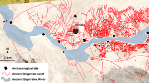
Figure 1. Topographic map of the Mesopotamian floodplain, drawn using Shuttle Radar Topography Mission data, showing the location of the Eridu Region and the networks of modern and ancient rivers and canals in the floodplain (after Jotheri Reference Jotheri2016: fig. 2:30).

Figure 2. An example of a contemporary crevasse splay on the modern Euphrates 30km north-east of the Eridu Region: A) Corona satellite image taken in 1968; B) the reconstructed crevasse splay, illustrating how farmers can modify a crevasse splay, dig irrigation canals, build a barrage to control the flooded water and claim land for farming in southern Mesopotamia (figure by authors).
Most of the ancient irrigation canal networks now visible on the ground in modern Iraq belong to the Parthian and Sasanian periods (from the late first millennium BC) onward (Adams Reference Adams1981; Jotheri & Allen Reference Jotheri, Allen, Lawrence, Altaweel and Philip2020). The older irrigation networks were covered by the younger networks or the sedimentation of rivers. Consequently, little is known about earlier irrigation canals and associated farms—evidence as to size, shape, location and extent has largely been erased. By contrast, the Eridu region of southern Mesopotamia (Figure 1) was occupied from the Early Ubaid until the Neo Babylonian periods (late sixth to early first millennium BC) (Safar et al. Reference Safar, Mustafa and Lloyd1981). A shift in the ancient course of the Euphrates River left this region dry and consequently unoccupied after the early first millennium BC until now (Adams Reference Adams1981). This has allowed the archaeological landscape of this region to remain intact and thus we were able to identify and map a vast, intensive and well-developed network of irrigation canals that pre-date the early first millennium BC.
Methodology
The present study implemented a combination of geological, geomorphological, remote sensing, historical and archaeological approaches. Geological and geomorphological maps of the region were reviewed. Satellite images (Figure 3) of different resolutions and times, including historic CORONA imagery, were consulted. Fieldwork was carried out, including the ground-checking of remote-sensing work and the collection of drone images and camera photography (Figure 4). Differentiation between natural and artificial canals includes consideration of canal patterns, topographic cross-sections, crevasse splays, marshes, meanders, cut-offs and oxbow lakes, and stream directions—these were assessed using the criteria and methods described by Jotheri (Reference Jotheri, Zhuang and Altaweel2018).

Figure 3. Top) high-resolution Digital Globe satellite image taken in 2006 showing part of the Eridu archaeological site and part of the irrigation canal network to the east of the site; bottom) a reconstruction of the ancient irrigation canal in this area (in red) (figure by authors).

Figure 4. Ground-truthing of the remote sensing work: A) drone images show two minor irrigation canals; B & C) photographs of the two small canals (figure by authors).
Results
A vast and well-developed network of artificial irrigation canals, including more than 200 primary and large canals, was identified and mapped (Figure 5). The main canals are directly connected to the ancient course of the Euphrates and are between 1 and 9km long, and between 2 and 5m wide. Moreover, more than 4000 minor and branch canals connected to the main canals are identified. The length of these branch canals is between 10 and 200m while the width is between 1 and 2m. More than 700 farms are identified, and minor or branch canals are typically found around the perimeter of each farm. The area of each farm is between 500 and 20 000m2 (Figure 6). It seems that the ancient course of the Euphrates stayed in its riverbed for most of the time the farms were occupied, only moving laterally within the riverbed. There were no avulsions or significant shifts of the river in the region during the period of occupation, allowing the primary canals to connect with the river continuously. Both sides of the river were canalised and farmed, although farmers exploited the northern side more heavily than the southern side.

Figure 5. The reconstructed irrigation canal network in context with the ancient Euphrates riverbed and the archaeological sites of the Eridu region. The base map is a Corona satellite image (figure by authors).

Figure 6. An example of the intensive farms and irrigation canals in the Eridu region: left) high-resolution Digital Globe satellite image taken in 2006; right) the reconstructed canals and farms. The main canals are longer and wider and connected to each other. Farms are mostly divided by smaller canals (figure by authors).
Conclusions and future work
This reconstructed network of irrigation canals represents the combined agricultural activities for all the periods of occupation in the region and it is unlikely that all of the canals were running simultaneously during the entire occupation period (i.e. from the sixth until the early first millennium BC). Canals require immense labour and experience in water management to operate successfully (Lang & Ertsen Reference Lang and Ertsen2024). Therefore, it is essential to conduct additional research on the chronology of the canals to better understand changes in the irrigation systems and agricultural landscape over time. Reconstruction of the ancient marshes in this region would also indicate any reclamation and exploitation activities. Finally, comparing the character and dimensions of the canals and farms with contemporaneous descriptions in the texts of the cuneiform tablets could provide additional, valuable insights into agricultural practices and management in the Euphrates floodplain and in Mesopotamia more broadly.
Funding statement
The British Institute for the Study of Iraq in London funded this project.


 Open access