Introduction
Located at the centre of the Marsala Lagoon on the western coast of Sicily, the 40ha island of Motya (modern San Pantaleo) was the site of a flourishing settlement in the Bronze and Iron Ages. The island offered natural resources, including salt, fish and fresh water, and a well-protected harbour at a strategic location between North Africa, Iberia and Sardinia (Nigro & Spagnoli Reference Nigro and Spagnoli2017: 111). From the second millennium BC onwards, it attracted people from across the ‘Middle Sea’ (Nigro Reference Nigro and Lemaire2014b, Reference Nigro and Cazzella2016).
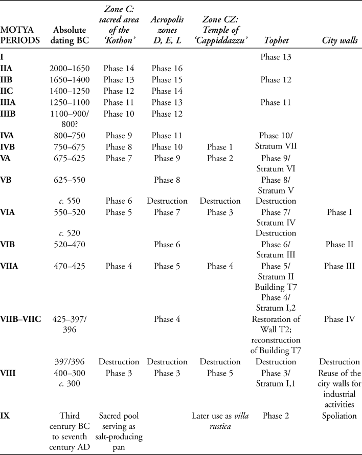
Four main periods of occupation have been identified on the acropolis of the site (see Table 1: zones D, E & L; for full version, see Table S1 in the online supplementary material (OSM)): Motya IIA and IIB–C (2000–1250 BC) and Motya IIIA and IIIB (1250–900 BC). Around the beginning of the eighth century BC (Motya IVA), Phoenician settlers arrived on Motya, integrating with the local population (later known as ‘Elymians’) and giving rise to a distinctive “West Phoenician cultural identity” (Nigro & Spagnoli Reference Nigro and Spagnoli2017: 113). By the seventh century BC, the settlement had developed into an important port-city, with a wide exchange network across the Central and Western Mediterranean. As a result, Motya soon came into conflict with Carthage, the rising power on the opposite side of the Strait of Sicily, on the North African coast. Towards the middle of the sixth century BC, Carthaginian forces led by General Malco destroyed Motya, but the city swiftly recovered, with the building of an impressive city wall at the beginning of Motya VIA amongst the earliest such structures in the Central Mediterranean (Nigro Reference Nigro2019d, Reference Nigro2020). Other monumental constructions within the city at this time included two major religious areas, one to the north and one to the south. The city wall and the two religious compounds represent key redevelopments that suggest the city had strengthened its status as a Central Mediterranean counterpart to Carthage.
Table 1. Stratigraphic periods and phases in the main areas of Motya (for full version, see Table S1 in the OSM; for dating, see Ciasca Reference Ciasca1992; Nigro Reference Nigro and Cazzella2016, Reference Nigro and Guirguis2018, Reference Nigro2020).
For almost 60 years, the Sapienza Università di Roma and the Soprintendenza per i Beni Culturali ed Ambientali of Trapani have collaborated on the exploration of Motya, undertaking 42 seasons of excavation. These investigations have made it possible to establish a site-wide chronology based on 16 excavation areas (Nigro Reference Nigro and Guirguis2018: 254; Figure 1; Table S1). The most recent campaigns, undertaken between 2002 and 2020, have focused on the large (52.5 × 37m) rectangular, stone-lined water basin, known in the archaeological literature as the ‘Kothon’, located in the southern part of Motya. Previous investigations of this feature concluded that it was an artificial inner harbour connected with the city's role in Mediterranean trade. Here, the results of the latest fieldwork are used to present a complete re-interpretation of the architecture and function of the ‘Kothon’, arguing that it was, instead, a sacred pool at the centre of a monumental sanctuary with possible astronomical functions.
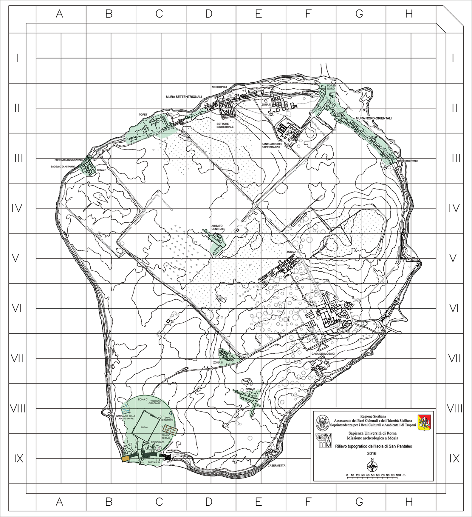
Figure 1. Map of the island of Motya showing the sacred area of the ‘Kothon’ in the south-western quadrant (© Sapienza University of Rome Expedition to Motya).
The ‘Kothon’: its exploration and interpretation
The term ‘kothon/cothon’ was used by Greek and Latin authors (Appian. Pun. 127; Strabo 17.3.15; see Horace Reference Horace1972: 627–28; Biffi Reference Biffi1999) to describe the military harbour of Carthage, a circular basin with an island at its centre (Vecchio Reference Vecchio and Nigro2004: 35). Following this classical definition, scholars have applied the term to several similar structures found elsewhere across the Mediterranean, including at the site of Motya (Carayon Reference Carayon2005). The ‘Kothon’ at Motya was first explored in the early 1900s by the Anglo-Sicilian pioneer archaeologist Joseph Whitaker (Pace Reference Pace1915). Whitaker mistook a channel leading from the basin as a means of accessing the sea, consequently identifying the basin as harbour, which he labelled a “Carthaginian cothon” (Whitaker Reference Whitaker1921: 188–93). Subsequently, work was undertaken by the British Expedition at Motya between 1955 and 1970 (Isserlin Reference Isserlin and Romanelli1961, Reference Isserlin1962, Reference Isserlin1970, Reference Isserlin1971a, Reference Isserlin and Niemeyer1982; Isserlin et al. Reference Isserlin, Parr and Culican1956, Reference Isserlin, Culican, Brown and Cutroni1958, Reference Isserlin, Coldstream and Snodgrass1970). A synthesis of the results was published by the director of the expedition, Benedikt Isserlin, in Antiquity 50 years ago (Isserlin Reference Isserlin1971b). Isserlin revised Whitaker's interpretation, arguing that the feature was a type of dry dock for the careening or repair of ships (Isserlin Reference Isserlin1973, Reference Isserlin1974a; Isserlin & Du Plat Taylor Reference Isserlin and Du Plat Taylor1974: 57).
Renewed excavations in the area surrounding the ‘Kothon’ now permit a more fundamental reinterpretation of this feature. The basin is located at the centre of a monumental religious complex dating to 550–397/396 BC (Motya VI–VII) and comprising three main temples (Nigro Reference Nigro and Afeiche2012a: 381–83) (Figure 2). It is argued here that the basin was not a harbour but, rather, a sacred pool, which collected fresh water and may have served for the observation of the movement of stars that were important for Phoenician navigation. Temples, architectural niches, stelae and other features within the complex were orientated towards rising and setting stars and constellations of practical and symbolic significance (e.g. equinoxes, solstices). This new interpretation notwithstanding, in homage to Joseph Whitaker (the first person to investigate this feature), the term ‘kothon’ is retained in the present article.

Figure 2. Aerial view of the sacred area of the ‘Kothon’ on the island of Motya, with the main structures investigated by Rome ‘La Sapienza’ University (© Sapienza University of Rome Expedition to Motya).
The sacred area of the ‘Kothon’: the temples and the circular temenos
The renewed exploration of the Motya basin followed the excavation, between 2002 and 2010, of a large cultic building—the Temple of Ba'al (Figure 2)—that was in use from c. 800 to 397/396 BC (Motya VI–VII) (Nigro Reference Nigro, Nigro and Rossoni2004: 68–71, Reference Nigro and Ampolo2009a: 551–52, Reference Nigro, Fortunelli and Masseria2009b: 703–708, Reference Nigro, Doumet-Serhal and Maila-Afeiche2015a: 84–93; Nigro & Spagnoli Reference Nigro and Spagnoli2017: 49–53). Further excavations between 2009 and 2021 revealed the temenos wall, 0.7–1.5m wide and 3m high, which encloses the ‘Kothon’ and the Temple of Ba'al within a circular, 118m-diameter area (Nigro Reference Nigro and Guirguis2018: 262–68, Reference Nigro, Ferjaoui and Redissi2019a: 1650–52). The investigation of the temple and the temenos, both of which were associated with religious activities, changed our interpretation of the ‘Kothon’ significantly, as did the discovery that the basin was fed by three subterranean freshwater springs. Further investigations within the temenos enclosure have revealed a second temple, dedicated to the Syro-Phoenician goddess Astarte (Nigro Reference Nigro2015b: 236–44, Reference Nigro and Guirguis2018: 269–71, Reference Nigro, Blakely and Collins2019b), and a third building on the western side of the complex, labelled the ‘Sanctuary of the Holy Waters’ on account of the cultic and hydraulic installations found within (Nigro Reference Nigro, Bouffer, Belvedere and Vassallo2019c: 149–52).
The earliest phases of the temples of Ba'al (Shrine C14, then Temple C5) and Astarte (Shrine C12) date to the arrival of Phoenician settlers on the island (Motya IVA, 800–750 BC; Nigro & Spagnoli Reference Nigro and Spagnoli2017: 8–9, 49–56). At this stage, the site of the later ‘Kothon’ was a natural spring-fed pond, with a block-lined side. Both temples underwent major reconstructions at the beginning of Motya VI (550–470 BC), when the entire city was rebuilt in a monumental fashion. At this time, the natural pool was transformed into the more formal, stone-lined basin that became known as the ‘Kothon’, a rectangular structure orientated north-northeast to south-southwest at the centre of the temenos enclosure wall. By Motya VI–VII (550–397/396 BC), the complex enclosed within the circular temenos wall comprised the spring-fed pool and three temples: the Temple of Ba'al (C1–C2 at this stage), laid out at a right-angle to the south-eastern arc of the enclosure wall (Nigro Reference Nigro2007a: 25–27, Reference Nigro, Gruber, Ahituv, Lehmann and Talshir2012b: 301–303, Reference Nigro2014a: 9); the Temple of Astarte (C6–C4 at this stage) in the north-east of the temenos and aligned on the pool's long axis (north-northeast to south-southwest); and the Sanctuary of the Holy Waters (C9–C7 at this stage) within the north-western arc of the temenos wall, where it deviates sharply, proceeding for a short distance in a straight line. This line, if projected, runs towards the midpoint of the south side of the basin.
Excavation and survey work allow us to identify the planning concept behind the sacred complex, and the functional and symbolic nature of its various alignments. The arrangement of buildings, stelae, altars, bothroi (pits), votive offerings (Spagnoli Reference Spagnoli, Blakely and Collins2019: 344–47) and other features within the enclosure suggest a place of religious activity dedicated to the sacred waters, the sky and the associated gods—all key elements of Phoenician religious beliefs. The Temple of Ba'al is orientated approximately east-southeast (110°), where the constellation of Orion (known as Ba'al to the Phoenicians) rises at the winter solstice (Nigro Reference Nigro and Antonello2010). The temple's main entrance is orientated to the south-southwest (200°). During excavation of this temple, the bronze pointer of a navigation tool, or astrolabe, was recovered (Nigro Reference Nigro2009c: 40), supporting the suggestion of an astral orientation. Meanwhile, the Temple of Astarte is orientated south-southwest (200°), where the planet Venus (the goddess Astarte/Aphrodite) rises in summer; conversely the niche, which would have housed the likeness of the goddess, is on the northern side of the temple, orientated towards the nearby Mount Eryx. The latter was the site of the Elymian city of the same name (Nigro Reference Nigro2015b: 236–37) and the location of a renowned temple of Astarte/Aphrodite/Venus, noted by Cicero (e.g. Verr., II, 2, 2, 24-5; 2, 2, 92-3 e 115 e 2, 5, 141) for its wealth and sacred prostitution (Ribichini Reference Ribichini, Blanco, Séiquer and Vivancos2000; Lietz Reference Lietz2012: 84–86, 199–206).
On the western side of the ‘Kothon’, the Sanctuary of the Holy Waters was associated with the sunset and the netherworld. It originally included a temple (C7) with a long room orientated east-northeast (Motya VI–VII, 500–397/396 BC), a shrine (C9) and an area for offerings. A huge votive pit lined with stone and filled with offerings in the form of animal bones possibly formed a mundus, or portal to the underworld. The pit was covered by two large stone anchors set side by side into the floor at the terminus of the temenos wall, in an arrangement that finds parallel at the contemporaneous city of Kition in Cyprus (Nigro Reference Nigro2015b: 234–35, Reference Nigro and Guirguis2018: 271–73).
The ‘Kothon’ and its re-interpretation
The ‘Kothon’ was excavated over two seasons: in 2005, when it was drained and the perimeter wall of stone blocks was cleared of vegetation (Nigro Reference Nigro2006: 44), and in 2013, when the pool was drained again and excavated by mechanical means (Nigro Reference Nigro2014a: 20–23). These excavations identified channels that conveyed water from the freshwater springs into the pool (Nigro Reference Nigro and Guirguis2018: 262–63, Reference Nigro, Ferjaoui and Redissi2019a: 1646–48). Critically, these investigations also confirmed that, at no point during the life of the Phoenician city (eighth to fifth centuries BC), was the pool ever connected to the Marsala Lagoon and hence to the open sea. Following the destruction of Motya in 397/396 BC, the city wall between the South Gate and the south-western corner tower was dismantled to create a dry dock and a small channel dug to connect the pool to the lagoon. Subsequently, in the Roman period (second to fourth centuries AD), the ‘Kothon’ was repurposed for fish farming and activities, such as the production of lime (Nigro Reference Nigro, Tusa and Buccellato2015c: 18–19); later, between the sixteenth and eighteenth centuries, the pool was used as a salt pan (Vecchio Reference Vecchio and Nigro2004: 35–36). It was the post-Phoenician-phase channel, connecting the lagoon to the pool, which led Whitaker to identify the latter as a harbour, or “Carthaginian cothon” (Whitaker Reference Whitaker1921: 188–93). Although Isserlin correctly recognised the channel as a dry dock (Isserlin Reference Isserlin1973, Reference Isserlin1974a; Isserlin & Du Plat Taylor Reference Isserlin and Du Plat Taylor1974: 57), he overlooked the fact that it could not have served as an inlet to a hypothetical navigable basin (Isserlin Reference Isserlin1972, Reference Isserlin1974b).
The 2013 excavation revealed that the rectangular pool (52.5 × 37m) was delimited by a continuous wall of ashlar blocks, arranged over five to six stepped courses (Nigro Reference Nigro2014a: 32–34). This is particularly clear on the south side (Nigro Reference Nigro2014a: 66–71) (Figure 3). Along the north side, a platform (M.4555) projecting approximately 0.52m (Figures 4 & 5) over the pool's edge would have allowed water to be drawn or ablutions performed (Nigro & Spagnoli Reference Nigro and Spagnoli2012: 3; Nigro Reference Nigro and Guirguis2018: 257).
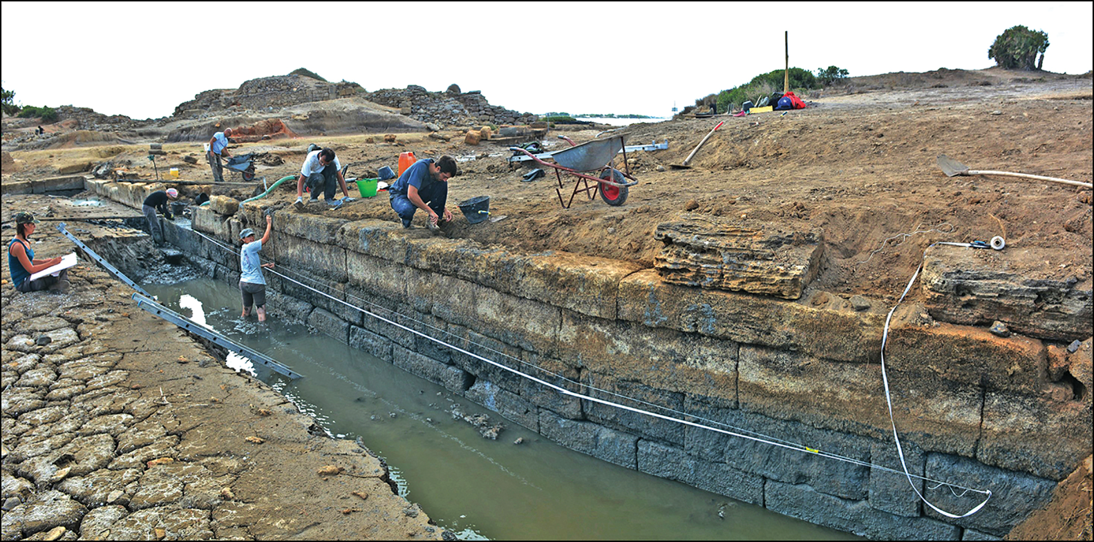
Figure 3. The southern wall of the ‘Kothon’, section M.4575 (see Figure 4) separating the pool from the Marsala Lagoon; viewed from the north (© Sapienza University of Rome Expedition to Motya).

Figure 4. Plan of the artificial freshwater basin (‘Kothon’). The section shows the ancient and modern water levels across this sacred pool (© Sapienza University of Rome Expedition to Motya).

Figure 5. Protruding ledge M.4555 (see Figure 4), roughly at the mid-point of the northern side of the ‘Kothon’; viewed from the west (© Sapienza University of Rome Expedition to Motya).
Excavation behind the north and east walls of the pool allows us to connect the constructional history of the ‘Kothon’ with the stratigraphy of the sacred area and the city as a whole. The ‘Kothon’ originated as a pond created by natural springs, which was initially reworked as a dock during Motya IVB (750–675 BC) and then transformed into the rectangular pool in Motya VIA (550–520 BC), retaining this form until the destruction of the city at the end of Motya VII, in 397/396 BC. In the modern period, when the pool was used as a salt pan, the rising sea level—approximately 0.8m higher than in antiquity—required the pool to be raised (Tusa Reference Tusa and Nigro2004: 449–51; Ravanelli et al. Reference Ravanelli2019).
The bottom of the pool was cut into the clayey marl bedrock and sloped gently down from north to south (Nigro Reference Nigro2014a: 32–34). At the north end, the water depth would have been 0.8m, increasing to a maximum of 1.5m at the south end (Figure 5). The pool was therefore not navigable, except by small service boats. The latter would have been necessary to reach the rectangular stone podium situated at the centre of the pool. In later years, nearly all the blocks forming the podium were removed and reused at the pool's south-western corner (Nigro Reference Nigro and Guirguis2018: 262–63), where they were used to contain the rubble resulting from the collapse of the city wall's south-west corner tower (Figure 2) (Isserlin Reference Isserlin1974b: 194; Nigro Reference Nigro2014a: 28–31).
Comparison with the contemporaneous Amrit sanctuary in Syria (Mingazzini Reference Mingazzini and Ciasca1968: 105–112; Dunand & Saliby Reference Dunand and Saliby1985)—a Phoenician temple with a sacred pool—suggests that the podium, situated on the central axis of the pool, may have served as the base of a shrine hosting a statue (Nigro Reference Nigro, Mastino, Spano and Zucca2009d: 89–93, Reference Nigro2014a: 90–91, Reference Nigro and Guirguis2018: 263). Blocks were offset on the pool's northern side (M.4555 in Figures 2, 4 & 5) as a means for entry. This hypothesis is supported by the discovery, on the perimeter of the Motya basin, of a stone block featuring an Egyptian gola (a decorative moulding) on a pedestal and a large, sculpted foot (Nigro Reference Nigro2014a: 26–29) (Figure 6). The latter is compatible with a statue of a male deity (Figure 7) recovered from the lagoon in 1933 (Mingazzini Reference Mingazzini1938; Falsone Reference Falsone1970) and now on display at the Museo Archeologico Regionale A. Salinas in Palermo (Fontan & Le Meaux Reference Fontan and Meaux2007: 331).

Figure 6. Block with the carved foot of a statue found on the edge of the pool (© Museo Archeologico Regionale A. Salinas, Palermo).

Figure 7. Sandstone statue of a male deity found in 1933 in the Marsala Lagoon (height: 1.28 m), Palermo, Museo Archeologico Regionale A. Salinas (© Museo Archeologico Regionale A. Salinas, Palermo).
The identity of the statue is suggested by the discovery of an inscription with a Greek dedication to ‘Belios’ (Ba'al), found in a votive pit beside the south-eastern corner of the pool (Guizzi Reference Guizzi, Nigro and Spagnoli2012: 13–15). We argue that this statue stood on the podium at the centre of the ‘Kothon’, its large dimensions—approximately 2.4m high—personifying the mighty Ba'al (Figure 8), and the arrangement constituting the spatial and ideological fulcrum of the entire sanctuary. In 2019, a replica of the statue was placed at the centre of the pool to recreate the visual impression that might have been experienced by an inhabitant of ancient Motya (Figure 9).
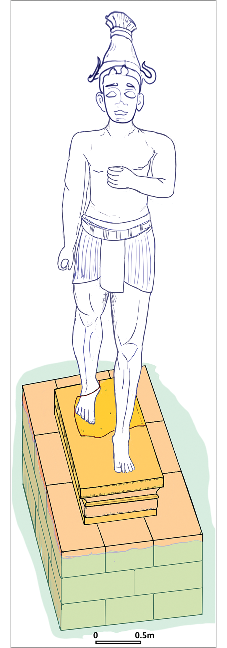
Figure 8. Graphic reconstruction of the podium erected in the centre of the ‘Kothon’ supporting the statue of Ba'al (© Sapienza University of Rome Expedition to Motya).

Figure 9. View of the refurbished ‘Kothon’ with a replica of the statue of Ba'al at its centre (© Sapienza University of Rome Expedition to Motya).
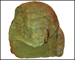
Moreover, it has been argued that the circular temenos and the sacred pool constituted a vast astronomical observatory (Nigro Reference Nigro2009c). This interpretation is suggested by several finds, including the pointer of a navigation instrument in the Temple of Ba'al (noted above), and the discovery, in the north-eastern corner of the pool, of a worn statue of a dog-headed baboon—the personification of the Egyptian god Thoth, the god of knowledge and wisdom, who was associated with astronomy (Dothan & Regev Reference Dothan and Regev2011) and often depicted in zodiacs (e.g. at Dendera; Priskin Reference Priskin2015) (Figure 10). Temples to the latter in ancient Egypt also featured sacred pools (Gessler-Löhr Reference Gessler-Löhr1983).
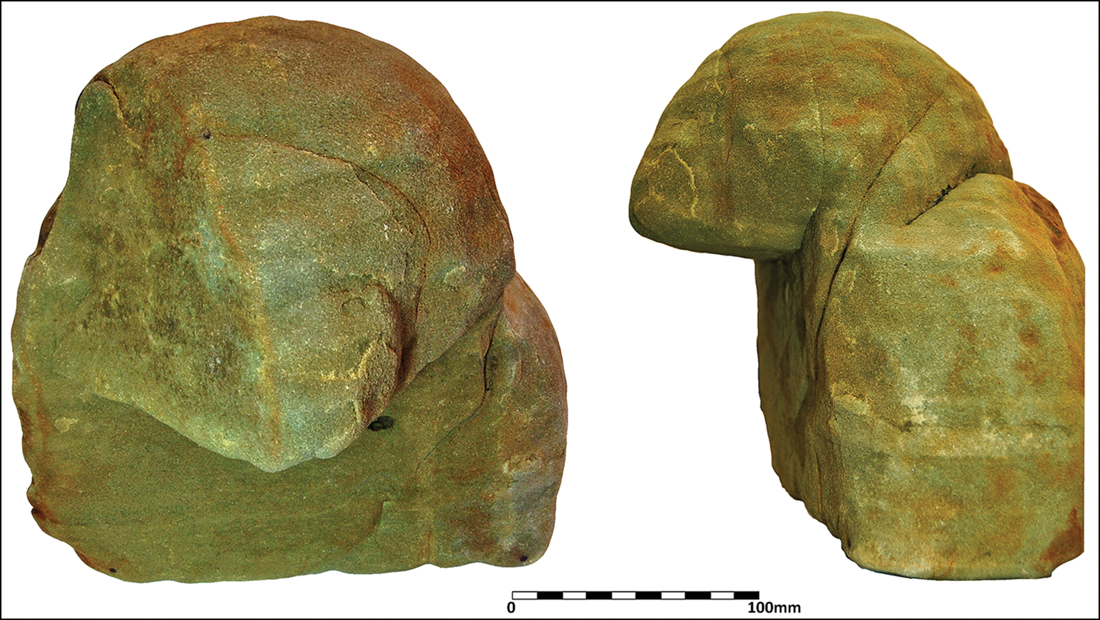
Figure 10. Worn fragment of a sacred baboon figure (MC.12.120) made of Egyptian green sandstone, found in the north-east corner of the ‘Kothon’ (© Sapienza University of Rome Expedition to Motya).
The reflecting surfaces of pools could be used for astronomical observations by using poles to mark the position of stars reflected in the water, allowing the observation and measurement of celestial bodies and their angles relative to the horizon. The constellations and their positions in the night sky on significant dates, such as solstices and equinoxes, are mirrored in the alignments of the main structures at the site, as well as through sacred features that include stelae carefully placed within the temenos to mark the rising, zenith, or setting of the stars over the horizon (Nigro Reference Nigro and Antonello2010).
The stars and constellations were regarded by the Phoenicians as gods and sacred ancestors. Foremost of these was Ba'al, represented by the constellation Orion (Nigro Reference Nigro, Helas and Marzoli2007b: 262–65, Reference Nigro and Antonello2010). The Temple of Ba'al, its propylaea (gateway) and a number of aligned stelae are all orientated towards the point on the horizon where Orion rises immediately after sunset at the winter solstice, a point which coincides with the rising sun on that day (for an archaeoastronomical reconstruction of the sky at the time the temple was rebuilt, c. 550 BC, see Nigro Reference Nigro2009c). This spatial organisation connects the architectural layout of the sacred area with the symbolism of Ba'al (Egyptian Osiris), the god who supported the rebirth of the sun (Frankfort Reference Frankfort1948: 168).
Discussion
The reinterpretation of the results from the new excavations at Motya make the city's ‘Kothon’ one of the largest and better-known sacred pools of the pre-Classical Mediterranean world. Together with the ‘Maabed’ of Amrit in Syria, it illustrates the multiple functions and varied symbolism of cult installations in the Phoenician world. The Phoenicians shared in and helped to transform and transmit a broad tradition connected with springs, water and related cult installations (Spagnoli Reference Spagnoli, Tvedt and Oestigaard2014; Bouffer et al. Reference Bouffer, Belvedere and Vassallo2019). Sacred lakes or pools are also known in Egypt, where they were dedicated to the gods Amun (at Karnak), Mut (at Tanis) and Thoth (at Hermopolis)—the latter possibly hosting sacred ibis (Threskiornis aethiopicus)—as well as in Mesopotamia, where pools were used for sacred fish (an ongoing tradition at Urfa, Turkey, in the pool of Abraham's Mosque). Pools could also host a range of other sacred animals, including geese, fish, ibis and even baboons. These sacred sites were used for purification rituals for both humans and cult images (Gessler-Löhr Reference Gessler-Löhr1983).
The spatial layout of the ‘Kothon’ and the surrounding temenos at Motya also leads us, moreover, to argue that the circular enclosure was conceived to represent the celestial vault. As Leonardo da Vinci would later suggest, pools are well suited for observing and measuring the night sky on account of their perfectly horizontal surfaces. The area of the circular temenos provided a space within which the sky and stars could be plotted on the Earth, in a manner that was compatible with representations of the sky known from antiquity (e.g. the Dendera zodiac from Egypt: Priskin Reference Priskin2015; or the Dougga ‘Rose of the Winds’ from Tunisia: Aounallah & Golvin Reference Aounallah and Golvin2017: 285–355). Capella (Alpha Aurigae), the sixth brightest star in the night sky, rises to the north at the autumn equinox, and its position is marked by a niche with evidence of offerings in the Motya temenos (Nigro Reference Nigro and Guirguis2018: 267–68 & fig. 22). At the autumn equinox, Sirius (Alpha Canis Major)—the brightest star in the night sky—rises to the south, a position marked by the South Stela (Figure 2). Finally, Orion, identified with the Phoenician god Ba'al, rises to the east-southeast at the winter solstice; Motya's Temple of Ba'al is orientated in this direction.
Conclusion
Fifty years after the investigations of Isserlin, recent excavations at Motya demonstrate that the ‘Kothon’ was not a maritime harbour but, rather, a freshwater pool. Moreover, positioned at the centre of one of the largest cultic complexes of the pre-Classical Mediterranean, the pool also served cultic functions, hosting a statue of Ba'al and permitting the observation of the night sky. The recent discoveries at Motya have wide implications, especially in connection with the origins of the Phoenician settlement, its transformation into a city and the function of some of its major monuments. The cultic and astronomical role played by the sacred enclosure and pool in the origins and development of Motya, advanced here, adds another element, showing that Motya was open to cultural interactions and hybridisation, counterbalancing Carthage's growing political and economic domination. Consequently, Motya was a site quite different from the rising western Phoenician power of Carthage. It remained a flourishing free-port and, in time, developed an open attitude, especially towards Greece and the Greek cities of Sicily. Carthage's disappointment with this attitude, however, was the cause of a delay in help for Motya, when the tyrant Syracuse Dionysius placed the city under siege and then destroyed it in 397–396 BC.
Acknowledgements
The author is grateful to the Superintendence of Trapani of Region Sicily and the G. Whitaker Foundation, Palermo, for fruitful cooperation in the excavations at Motya over the last two decades. This article is dedicated to the late Sebastiano Tusa, Assessor of Culture and Superintendent of the Sea of Sicily, who strongly supported the Sapienza Archaeological Expedition to Motya and the re-excavation of the ‘Kothon’.
Funding statement
The excavations at Motya are supported by Sapienza Università di Roma (Fund Great Excavations) and the Ministry of University and Scientific Research of Italy. This article also benefitted from the PRIN2017 Fund within the project People of the Middle Sea. The author gratefully acknowledges the Honor Frost Foundation in London for support during the 2013 season.
Supplementary material
To view supplementary material for this article, please visit https://doi.org/10.15184/aqy.2022.8


