1. Introduction
The Bohai Sea, China, is the southernmost oceanic basin in the Northern Hemisphere to exhibit annual freezing. Affected by solar and atmospheric (i.e. Eurasian winter monsoon) forcing, sea-ice formation occurs in the Bohai Sea as early as December and the ice is completely melted by the end of the following March. Therefore, the ice period of the Bohai Sea is >3 months every year.
Observations and investigations of sea ice were begun in China at the end of the 19th century and information on the early work can be found in various sources. However, only after the 1960s was systematic and intensive research carried out. Overall, the early studies mostly reported when sea ice was a hazard to marine transportation and engineering. With the shortage of water in the Bohai Rim, which has become an increasingly serious issue since the 1990s, some scientists have proposed the use of sea ice as a freshwater resource and have carried out studies to support this idea (Reference Shi, Ha, Yuan, Zhou and XieShi and others, 2002; Reference Wang, Su and LiuWang and others, 2003).
The theoretical basis for the exploitation of sea ice as a freshwater resource is that salts are expelled continuously during the thermal growth of sea ice. The salinity of new sea ice is <50% of that of the parent sea water, and in the winter season, especially during warm periods, further salts are ejected from the ice sheet. Thus, the salinity of sea ice is far lower than that of sea water. The salinity of Bohai sea water ranges from 29% to 3 1 %, whereas it is only 4–11% for sea ice (Reference ZhangZhang, 1979). Moreover, the salinity can be reduced even further to 0.2–2.0% using sea-ice desalination methods (Reference XieXie and others, 2009). Further analysis of meltwater from sea ice has demonstrated the feasibility of sea ice being exploited as a freshwater resource (Reference Xu, Chen, Liu, Zhang, Lin and GuanXu and others, 2003). Previous studies of such exploitation have also focused on the estimation of sea-ice volume (Reference Gu, Zhang, Xie, Li and CuiGu and others, 2003; Reference NingNing and others, 2009), the utilization of sea ice for agricultural irrigation (Reference Xie, Zhao, Li, Wu and XiaoXie and others, 2007) and the improvement of saline alkali soil with sea-ice meltwater (Reference Tao, Gu, Lin and Xu Yand BuTao and others, 2011). Important breakthroughs have been achieved in the technology of sea-ice ‘mining’ (Reference Shi, Gu, Wang, Wang, Lui and LiShi and others, 2010) and desalination (Reference GuGu and others, 2012). Compared with other conventional means of alleviating regional scarcity of fresh water, such as sea-water desalination and large-scale water-transfer engineering, with the use of low temperature and gravity as the basis of the technology, the exploitation of sea ice as a freshwater resource has great potential. Further scientific research and technical development will certainly promote realization of the industrial mass production of fresh water from sea ice.
However, owing to the ice environment and related factors, the volume and regeneration potential of sea ice differs among the sub-regions of the Bohai Sea. This inevitably leads to regional variations in the exploitation potential of sea ice. In addition, variations in environmental conditions in the coastal areas of the Bohai Sea restrict the implementation of sea-ice exploitation. Therefore, spatial distribution is the primary topic for feasibility studies of sea-ice exploitation in the Bohai Sea, but systematic studies on this issue have been rare. Accordingly, the aim of this study is to evaluate the feasibility of the Bohai Sea sub-regions for the exploitation of sea ice by analysing the environmental conditions.
2. Sea Ice in the Bohai Sea and Environmental Conditions
2.1. Bohai Sea and sea ice
The Bohai Sea is an inland sea in China located in the latitude–longitude rectangle 378070–418050 N, 1178350–1218150 E. Its main regions are Liaodong Bay, Bohai Bay, Laizhou Bay and the central Bohai Sea (Fig. 1). The mean water depth is 18m and the maximum depth is 85 m. Liaodong Bay is the northernmost region and contains most of the sea ice, followed by Bohai Bay. Ice conditions in Laizhou Bay are mild and unstable, and usually no ice forms in the central Bohai Sea (except during extreme years).

Fig. 1. The geography of the Bohai Sea together with the spatial distribution of sea-ice thickness on 31 January 2008.
Ice conditions in the Bohai Sea are dynamic. Sometimes when the wind becomes strong the drift ice will be pushed to pile up in the opposite coastal area (Reference ZhangZhang, 1979). As a result, in the regions where the ice piles up, such as the eastern coastal area of Liaodong Bay shown in Figure 1, the ice thickness can increase in a short time.
2.2. Environmental conditions influencing sea-ice exploitation
Mass production of fresh water from sea ice depends on several important factors. In addition to the quality of sea ice and the technologies of ‘mining’, desalination, storage and transportation, the most crucial factor affecting the development value of the resource is the actual sea-ice reserve (Reference Xie, Gu, Yuan and ChenXie and others, 2003). The diurnal maximum sea-ice volume of the Bohai Sea in recent years ranged from 1.3 to 6.0 × 10⁹ m3 (Reference YuanYuan and others, 2012). The volume of sea ice is huge, but it is dispersed throughout the Bohai Sea. Therefore, the spatial distribution of sea ice has a key role in determining the locations that are suitable for the mining of sea ice. Moreover, sea ice can regenerate after mining, and the formation and growth of sea ice is closely related to the air temperature, solar radiation, depth of the sea, salinity of sea water and turbulence and mixing of sea water in the sea. As for the Bohai Sea, the air temperature and water depth are the most important factors affecting the volume of sea ice that forms.
For the regional exploitation of sea ice, several engineering problems need to be solved. The most feasible method of sea-ice mining is still a shore-based technology, which is based on mechanical equipment to take the ice from the sea and ancillary facilities that extend from the shoreline to the sea area (Fig. 2). Using these ancillary facilities (trestle, railroad), sea-ice mining can pass over the intertidal zone where mining is difficult. The spatial extent of the ancillary facilities, determined by the width of the intertidal zone, should not be too large (<1000m) to lower the investment of capital in the construction and the cost of transportation of sea ice to shore. The water depth of the area for sea-ice mining should be large enough (>2m) to maintain normal mining operation. Therefore, the coastal conditions are the most crucial factors for sea-ice exploitation engineering.

Fig. 2. Mechanical equipment for taking (a) sea ice and (b) ancillary facilities for ice mining with the shore-based technology.
3. Data and Methods
3.1. Data sources
Information regarding the volume of sea ice was extracted from satellite images of the Bohai Sea taken mostly during the winter season (from December to March of the following year) from 1988 to 2011. The images were obtained from the US National Oceanic and Atmospheric Administration (NOAA) database of the University of Tokyo, Japan, and the China National Meteorological Centre. After excluding the images with cloud cover and other defects (stripe noises, salt-and-pepper noises, etc.), 580 images were selected from more than 2000 originals to determine the sea-ice extent and thickness. The extent can be clearly detected from the visual bands of the satellite data, and the thickness can be estimated based on the mathematical model reflecting the relation between sea-ice thickness and albedo (Reference Grenfell and PerovichGrenfell and Perovich, 1984; Reference YuanYuan and others, 2012). Furthermore, breakthroughs in the methods of estimation of sea-ice volume in the Bohai Sea (Reference Gu and ShiGu and Shi, 2004; Reference XieXie and others, 2006) make it possible to accurately evaluate the ice thickness of each gridcell in the 580 satellite images.
Air temperature data for the winter seasons in the Bohai Sea were obtained from the China Meteorological Administration (http://cdc.cma.gov.cn/home.do). Submarine topography information, coastline locations and coastal water depths were extracted from the marine chart of the Navigation Guarantee Department of the Chinese Navy Headquarters (2010). Sea-water salinity and wind direction data were obtained from a marine environmental atlas of the offshore areas of China (State Oceanic Administration of China, http://mds.coi.gov.cn).
3.2. Data processing
Firstly, the Bohai Sea area was rasterized and the marine chart was digitized by means of a spatial interpolation. The Bohai Sea mesh consisting of 73 944 gridcells (1 km × 1 km) was produced using ArcGIS 9.3 (GIS software by the Environmental Systems Research Institute).
The volume of sea ice can be determined from the area and the thickness of the ice cover. The spatial distribution and the local thickness of the ice, as well as other sea-ice properties, can vary daily. Therefore, it is not reasonable to determine the sea-ice resources in specific areas simply by the ice situation at a given time or on the basis of the normal conditions. In the present study, ice that was >10 cm thick was taken to equal the minimum level of guaranteed resources. The guarantee level of this ice was then defined as the Bohai Sea ice richness standard (according to the operating characteristics of the sea-ice mining equipment: if ice thickness is <10 cm, the operation efficiency is greatly reduced). The guarantee level can be equivalent to the frequency of ice mining days (F), which was calculated for each gridcell as
where x and y represent the geographic coordinates of any unit in the sea area and T(x, y) h >10 is the number of cases when the sea-ice thickness was >10 cm. The outcome is shown in Figure 3. In northern Liaodong Bay the frequency is >60%, while it is <50% at the shore of Bohai Bay.

Fig. 3. The frequency of sea ice >10cm thick in the winter season (December–March) in the period 1988–2011.
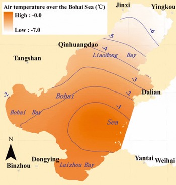
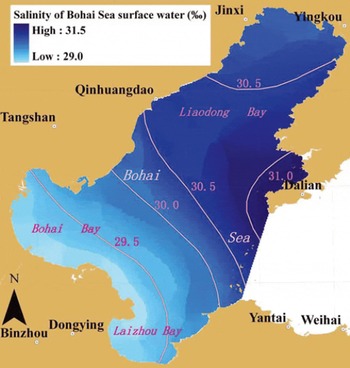
Using the same grid and the sampled data points, the index values of temperature, water depth and salinity for the Bohai Sea were calculated using the ‘Interpolation to Raster’ tool in ArcGIS 9.3. The resulting spatial distribution maps of air temperature and salinity in the Bohai Sea in the winter season are shown in Figures 4 and 5, respectively. In the northern half of Liaodong Bay the temperature is less than –5°C, but elsewhere the temperature is largely controlled by the open water areas. The surface salinity of the water is 29–31%, kept this low because of the Yellow River inflow into the Bohai Sea.

Fig. 4. The spatial distribution of air temperature over the Bohai Sea in the winter season.

Fig. 5. The spatial distribution of surface salinity in the Bohai Sea in the winter season (December–March).
3.3. Methods for evaluating location suitability
Based on the spatial differences of the factors that influence the exploitation of sea ice as a freshwater resource, the suitability of the study area was evaluated using a systematic analysis and a comprehensive assessment. These factors were classified into two types: (1) the sea-ice resources and (2) the environmental requirements for sea-ice mining. Sea ice is distributed throughout the sea area, but the environmental requirements were mainly connected to the state of the coastal area. Accordingly, the areas of the Bohai Sea were evaluated in two sections: the sea area and the coastal area. The sea area was examined using the grid analysis methods in ArcGIS, and the indexes related to sea-ice resource conditions were weighted and standardized for each gridcell. Then the overall layout of the suitability of the sea area was determined. The suitability of the coastal area was analysed and evaluated according to the spatial distribution of sea-ice resources and coastal environment conditions.
4. Evaluation of the Feasibility of Bohai Sea Sections For Sea-Ice Exploitation
4.1. Comprehensive Evaluation of the Sea Area
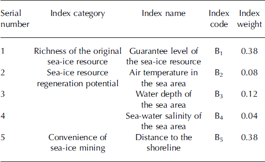
A comprehensive evaluation of the feasibility of the sea area for sea-ice exploitation should include measurements of the richness of the original (natural) sea ice and the potential for sea-ice regeneration. Moreover, for shore-based ice mining, the proximity to the ice at the coast is important. Accordingly, an index system of sea-ice resource conditions in the Bohai Sea area was constructed (Table 1) and a matrix was created for comparison of the significance of each index on the basis of expert opinion and associated discussion of results.
Table 1. The index system of sea-ice resource conditions in the sea area

After the indexes had been selected and weighted, the index value of each gridcell in the sea area (S) was calculated as

where wi is the weight of the ith index and bi is the value of the ith index after being standardized for the gridcell. Larger values correspond to better sea-ice resource conditions. The spatial distribution is shown in Figure 6.

Fig. 6. The spatial distribution of the sea-ice resource index (0–1) in the Bohai Sea.
Index values >0.60 can be taken to represent the areas with feasible sea-ice resources. Thus, according to the graphical representation (Fig. 6), the best areas are located mainly in the nearshore area of northern Liaodong Bay, in a narrow and long area along the coast of Bohai Bay and in a few sporadic spots elsewhere at the coast. The areas with index values >0.80 are located mainly at the end of Liaodong Bay and in the eastern coastal area of northern Liaodong Bay.
4.2. Analysis of the environmental conditions of the coastal area
According to the evaluation in Section 4.1, the nearshore area of northern Liaodong Bay and the narrow and long area along the coast of Bohai Bay should be considered for sea-ice exploitation. The detailed coastal conditions of these two key regions with good resource conditions are shown in Figures 7 and 8.

Fig. 7. The sea-ice resource index and the coastal environment conditions in northern Liaodong Bay.

Fig. 8. The sea-ice resource index and the coastal environment conditions in Bohai Bay.
A large area of the intertidal zone is located at the end of northern Liaodong Bay where the width of the zone is >5km (Fig. 7). This is highly unfavourable for the mining of the abundant sea ice on the coast. The conditions are superior on the eastern and western coasts of northern Liaodong Bay where the width of the intertidal zone is <1 km. There is also a large shallow water area, especially at the end of the bay and on the eastern coast, with a value of the sea-ice resource conditions index >0.80. The wide intertidal zone and the large shallow water area constrain the mining of sea ice in northern Liaodong Bay, but some regions with good conditions for coastal sea-ice exploitation can still be found, such as some coastal areas north of Changxing Island on the eastern coast and the coastal areas near Huludao and Juhua Island on the western coast (see the dotted circles in Fig. 7).
In Bohai Bay, the area with good sea-ice resource conditions begins at Caofeidian in the north and ends at Dongying Harbour in the south (Fig. 8). However, an obvious handicap for the mining of sea ice in this area is the intertidal zone, which is widely distributed along most of the coastal area: from the west of Caofeidian to Tianjin Harbour the width of the intertidal zone is ∼3 km; from south of Tianjin Harbour to Huanghua Harbour the width is ∼5 km; and south of Huanghua Harbour the width is as large as 10 km. Therefore, the width of the zone increases from north to south in Bohai Bay. The intertidal zone is narrow only at the harbours of Tianjin, Huanghua and Dongying due to the presence of other coastal engineering constructions. More importantly, the sea area with good resource conditions corresponds mostly to a shallow water area with a depth <2 m, except in the case of Dongying Harbour area and the adjacent sea area.
Conclusions
The feasibility of using sea ice as a freshwater resource in the Bohai Sea region has been investigated. The following conclusions are drawn:
-
1. The favourable sea areas are located mainly in the nearshore area of northern Liaodong Bay and in a narrow and long area along the coast of Bohai Bay.
-
2. Although in the northern end of Liaodong Bay the wide intertidal zone and shallow water along the coast restrict the exploitation of sea ice, there are still good coastal conditions on the eastern and western sides. As for Bohai Bay, the restrictions due mainly to the width of the intertidal zone exist throughout most of the coastal area.
Overall, northern Liaodong Bay is superior in exploitation potential compared with the other parts of the Bohai Sea. Some projects, such as that of the Bayuquan Branch Co. of Anshan Iron and Steel Co. Ltd, have already made preparations to exploit the sea ice in this coastal area for industrial water supply (Reference Xu, Wang, Gu, Jiang, Chen and YuanXu and others, 2010).
Acknowledgements
This research was supported by the National 863 Key Project of China (No. 2011AA100505), the projects of the State Key Laboratory of Earth Surface Progresses and Resource Ecology (2010-TD-02 and 2012-ZD-01) and the National Science and Technology Support Key Project of China (No. 2006BAB03A03). We thank the individuals in the working group for their help during the research.


