INTRODUCTION
Analyses of racial and ethnic segregation in the United States indicated three basic trends at the end of the twentieth century: (1) slow but steady declines in the degree of Black-White segregation (measured by the index of dissimilarity) with parallel declines in Black spatial isolation (measured by the P* index); (2) the continued residential segregation and spatial isolation of Asians at low to moderate levels with no significant trend upward or downward; and (3) steady Hispanic segregation at moderate to high levels combined with rising levels of Hispanic spatial isolation (Iceland Reference Iceland2009; Logan et al., Reference Logan, Stults and Farley2004; Massey et al., Reference Massey, Rothwell and Domina2009). Preliminary work based on the 2010 census has yielded widely discrepant reports on America’s progress toward integration. Whereas Logan and Stults (Reference Logan and Stults2011) see the persistence of segregation and argue that “the pace of integration has slowed to a standstill,” Glaeser and Vigdor (2011) proclaim “the end of the segregated century.”
The past forty years have witnessed a plethora of powerful demographic, economic, and social shifts that have transformed race relations in the United States to produce a more complicated residential configuration in American cities. Demographically, the nation has been reshaped by mass immigration from Asia and Latin America, changing the paradigmatic urban structure from the “chocolate city and vanilla suburbs” of the 1960s (Farley et al., Reference Farley, Schuman, Bianchi, Colasanto and Hatchett1978) to the “prismatic metropolis” of the new millennium (Zubrinsky and Bobo, Reference Zubrinsky and Bobo1996). In economic terms, inequalities of income and wealth have risen to record levels (Keister Reference Keister2000; Piketty and Saez, 2007; Wolff Reference Wolff2010), class segregation has increased (Massey and Fischer, Reference Massey, Fischer, Gale and Pack2003; Reardon and Bischoff, Reference Reardon and Bischoff2011), and the socioeconomic gap between Whites and minorities has widened, even as many minority members have moved into the middle class (Massey Reference Massey2007).
In the social realm, attitudes towards African Americans have shifted so that Whites no longer support segregation and discrimination as matters of principle, though many continue to harbor negative racial stereotypes, display limited tolerance of racial mixing, and offer little support for any form of civil rights enforcement (Bobo Reference Bobo, Krysan and Lewis2004; Bobo and Charles, Reference Bobo and Charles2009; Massey Reference Massey2011; Schuman et al., 1998). Latinos, meanwhile, have increasingly been demonized as a threat to American society and depicted in harsh, racially coded terms (Chavez Reference Chavez2001, Reference Chavez2008; Massey Reference Massey2009; Massey and Pren, Reference Massey and Pren2012a, Reference Massey and Prenb; Massey and Sanchez, Reference Massey and Sánchez2010; Santa Ana Reference Santa Ana2002). With respect to both groups, unconscious racism and prejudice also appear to be prevalent American social cognition (Banaji Reference Banaji, Roediger, Nairne, Neath and Surprenan2001; Fiske et al., 2009; Lee and Fiske, Reference Lee and Fiske2006; Quillian Reference Quillian2006) and play at least some role in shaping behavior (Bargh Reference Bargh, Greenberg, Koole and Pyszczynski2004; Ziegert and Hanges, Reference Ziegert Jonathan and Hanges2005).
Public policies enacted during the Civil Rights era appear largely to have ended overt racial discrimination in real estate and lending markets. Discrimination in housing was prohibited by the 1968 Fair Housing Act and discrimination in mortgage lending was banned by the 1974 Equal Credit Opportunity Act and the 1977 Community Reinvestment Act. As a result, minorities are no longer openly denied access to homes and credit, though audit studies reveal that traditional discriminatory practices continue surreptitiously (Charles Reference Charles2003; Ross and Turner, Reference Ross and Turner2004; Squires Reference Squires1994; Turner et al., Reference Turner, Freiberg, Godfrey, Herbig, Levy and Smith2002). In addition, new and more subtle forms of discrimination have been invented (Massey Reference Massey2005), including linguistic profiling (Fischer and Massey, Reference Fischer and Massey2004; Massey and Lundy, Reference Massey and Lundy2001; Purnell et al., Reference Purnell, Idsardi and Baugh1999; Squires and Chadwick, Reference Squires and Chadwick2006), predatory lending (Lord Reference Lord2004; Renuart 2004; Squires Reference Squires2004), and reverse redlining (Brescia Reference Brescia2009; Friedman and Squires, Reference Friedman and Squires2005; Rugh and Massey, Reference Rugh and Massey2010; Smith and DeLair, Reference Smith, DeLair, Turner and Skidmore1999; Turner et al., Reference Turner, Freiberg, Godfrey, Herbig, Levy and Smith2002; Williams et al., Reference Williams, Nesiba and McConnell2005).
In recent decades, density zoning has emerged as a powerful force promoting racial segregation. Limits on the density of residential construction in predominantly White communities drive up the cost of housing to make it unaffordable to low income, minority households (Glaeser et al., Reference Glaeser, Gyourko and Saks2005; Pendall Reference Pendall2000). As result, the more restrictive the density zoning regime (the stricter the limits on residential density), the higher the level of racial segregation and the less the shift toward integration over time (Rothwell2011; Rothwell and Massey, Reference Rothwell and Massey2009). Unsurprisingly, restrictive density zoning has also been linked to higher levels of income segregation (Rothwell and Massey, Reference Rothwell and Massey2010), and instrumental variable regressions suggest both relationships are not only strong, but causal.
In sum, whereas certain causes of segregation may have faded, new ones have appeared and the effects on levels and trends in residential segregation in the United States today are unclear. In this paper we seek to shed light on the true nature of the current situation by undertaking a systematic analysis of trends in the residential segregation and spatial isolation for Blacks, Whites, Hispanics, and Asians using a balanced panel of 287 metropolitan areas with consistently defined metropolitan boundaries from 1970 through 2010. After considering trends in segregation and spatial isolation, we specify and estimate a comprehensive explanatory model to reveal the underlying causes of residential segregation for Blacks and Hispanics in many quarters of the United States. In doing so we seek to identify the metropolitan circumstances in which segregation continues to be actively produced, and those in which shifts toward desegregation are facilitated.
DATA AND METHODS
Our principal data source is the Decennial Census of Housing and Population for 1970, 1980, 1990, 2000, and 2010 and the 2008–2010 American Community Survey. We extracted data on measures of residential segregation and spatial isolation for 1980–2010 from Logan and Stults (Reference Logan and Stults2011) for all metropolitan areas and divisions (hereafter MSAs) in the United States as defined in 2009. For 1970 we used data from the professional version of Social ExplorerFootnote 1 at the census tract level to compute segregation and isolation indices for MSAs as defined in 2009. Our dataset consists of a balanced panel of 287 consistently defined MSAs for which we were able to compute segregation indices for 1970–2010. The MSAs included in our analysis are listed in Appendix A.
Here we focus on two of segregation’s five constituent dimensions: unevenness and isolation (Massey and Denton, Reference Massey and Denton1988a). We measure unevenness using the well-known index of dissimilarity, which captures the degree to which the residential distribution of any two groups departs from the ideal of evenness. In an even distribution, each neighborhood has the same proportion of minority and majority members as the metropolitan area as a whole. Our indicator of neighborhood is the census tract and we consider three minority groups—non-Hispanic Blacks, non-Hispanic Asians, and Hispanics and compare their residential distribution to that of non-Hispanic Whites. Under these circumstances, the index of dissimilarity states the relative percentage of minority group members and non-Hispanic Whites who would have to exchange tracts to achieve an even residential distribution.
We measure a group’s spatial isolation using the P* index, which gives the minority percentage within the neighborhood of the average minority member. The Black isolation index, for example, gives the percentage Black in the neighborhood of the average African American residing in a particular metropolitan area. Whereas the dissimilarity index is invariant with respect to the minority-majority composition of a metropolitan area, the isolation index directly depends on the relative number of minority versus majority group members.
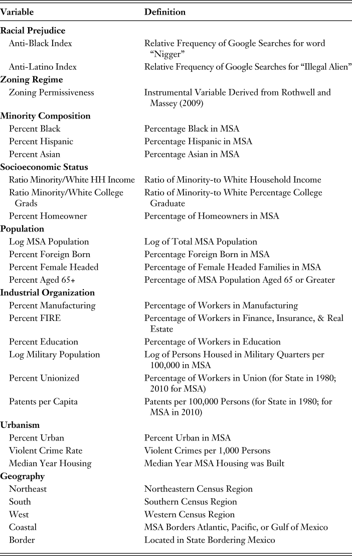
In order to consider the determinants of residential segregation and spatial isolation we assembled data on a variety of variables that prior studies have shown to be relevant in shaping residential outcomes in U.S. metropolitan areas, which are listed in Table 1. Until now investigators have been unable to measure variation in the extent of racial-ethnic prejudice across metropolitan areas, owing mainly to the cost of developing reliable survey estimates from probability samples of hundreds of different areas but also to the reluctance of respondents to admit to having prejudicial sentiments. Google Trends, however, offers new opportunities to assess topics that were previously difficult for survey researchers to tackle (Stephens-Davidowitz Reference Stephens-Davidowitz2013). For example, the most extreme expression of anti-Black sentiment and the harshest epithet one can apply to an African American is the word “nigger” and when we entered variations on this term into Google Trends we found it to be the subject of a large volume of internet searches that yielded a robust and quite variable distribution of frequencies across metropolitan areas since 2004.
Table 1. Independent Variables Used to Predict Segregation Outcomes for Blacks, Hispanics, and Asians

Stephens-Davidowitz (Reference Stephens-Davidowitz2013) performed a similar operation using Google Trends and found that the resulting index correlated strongly with other known measures of racial prejudice at the aggregate level; the index strongly predicted voter turnout for Obama across market areas in the 2008 presidential election. Whereas he used market areas, we employed metropolitan areas, which are smaller, and found that in some the volume of searches was too small to support a reliable index, and in these cases we substituted the state-level search frequency. On this index, the five most racist metropolitan areas were Flint, MI, Altoona, PA, Charleston, WV, Scranton, PA, and Wheeling, WV. The five least racist were Salt Lake City, UT, Ogden, UT, Provo-Orem, UT, Honolulu, HI, and Napa, CA.
When we entered various pejorative terms for Asians (chink, gook, etc.) into Google Trends, we did not find a sufficient volume of searches to provide a reliable index of Anti-Asian bias across metropolitan areas, suggesting a much lower level of hostility against this group. Likewise, when we entered various pejorative terms for Latinos into the system (spic, beaner, etc.) we also came up empty. However, recent decades have seen the rise of a Latino threat narrative in the media and public discourse tied to the framing of Latino immigrants as “illegal” (owing to undocumented migration) and therefore by definition “criminals” and “lawbreakers” (Chavez Reference Chavez2001, Reference Chavez2008). When we entered variations on the term “illegal immigrant” into Google Trends we again encountered a rather large volume of searches that yielded a robust and variable distribution of frequencies across metropolitan areas. As before, we substituted the state-level frequency whenever the volume was too low to sustain measurement within a particular metropolitan area. According to this index the lowest levels of anti-Latino sentiment were observed in Honolulu, HI, Bangor, ME, Cleveland, OH, Detroit, MI, and Lewiston, ME, whereas the highest levels occurred in Santa Barbara, CA, El Paso, TX, Brownsville, TX, Phoenix, AZ, and Tucson, AZ.
In addition to White animus toward certain minority groups, as noted above researchers have also demonstrated a strong causal connection between restrictive density zoning and both class and racial segregation (Rothwell and Massey, Reference Rothwell and Massey2009, Reference Rothwell and Massey2010). In their survey of local land regulations prevailing in forty-nine metropolitan areas, Pendall et al. (Reference Pendall, Puentes and Martin2006) asked 1,677 governmental units to report the maximum allowable density permitted in the jurisdictions they controlled. Localities that allowed less than four units per acre were coded 1; those that allowed four to seven units were coded 2; those permitting eight to fifteen units were coded 3; those allowing sixteen to thirty were coded 4; and those permitting thirty or more units per acre were coded 5. Rothwell and Massey (Reference Rothwell and Massey2009) computed the average density score across jurisdictions for each metropolitan area and found that it strongly predicted segregation, even after the application of rigorous controls.
In order to establish the causal effect of density zoning on segregation, they derived a prediction equation to estimate the density score as an instrumental variable, using year of statehood as the principal exogenous identifier. We borrowed their prediction equation and used it here to estimate density instruments for all metropolitan areas in our data set according to the following formula (1). Following Rothwell and Massey (Reference Rothwell and Massey2009), all predictors are defined as of 1980 except for the intergovernmental transfer variable, which was defined as of 1967 according to their formula.
Density Instrument = −48.394 + Year of Statehood * 0.007 + Percent Black * −0.006 + Percent Hispanic + 0.022 + Log of Population * −0.080 + Unionization Rate * −0.015 + Intergovernmental Transfers as a Share of Local Revenues * 0.005 + Coastal Location * 0.297 + Percent Urban * 0.004 + Share in Manufacturing * 0.021 + Median Age of Housing * 0.021 + Percent Homes Owner Occupied * −0.010 + Violent Crime Rate * −0.0002 + Ratio of Minority to White Median Family Income * 0.114.
The relative size of minority groups has long been recognized as a key determinant of segregation and discrimination. Sociologists have long argued that larger minority groups pose a greater threat to majority interests than smaller ones, in both symbolic and practical terms (Blalock Reference Blalock1967; Blau Reference Blau1977; Blauner 1972; Lieberson 1980). Symbolically, a larger minority population increases the visibility and salience of group members in public. Practically, more minority group members intensify competition for scarce public and private resources and can be expected to yield higher levels of residential dissimilarity.
In addition, the minority percentage has a direct mathematical relationship with the P* isolation index, essentially setting its lower bound. In a metropolitan area that is 20% Black and 80% White, for example, the minimum possible isolation index for African Americans is twenty, which would occur when the two groups are evenly distributed across neighborhoods (yielding a dissimilarity index of zero), thereby producing a distribution where every neighborhood is 20% Black. The upper bound, of course, would be 100, which would occur when all Blacks lived in neighborhoods that were 100% Black and all Whites lived in neighborhoods that were 100% White.
To a large extent, therefore, residential isolation is produced in urban areas by the confluence of a high level of dissimilarity with a large percentage of minority group members. Apart from these structural influences, the degree of segregation and isolation has been found to vary according to the socioeconomic status of the group in question (Denton and Massey, Reference Denton and Massey1988; Iceland Reference Iceland and Goering2007; Iceland et al., Reference Iceland, Sharpe and Steinmetz2005). Given that U.S. housing markets are segmented by price, and that wealth and income continue to vary sharply by race and ethnicity, intergroup differences in socioeconomic status translate into differences in residential status, leading to segregation (Massey and Denton, Reference Massey and Denton1985, Reference Massey and Denton1993). In general, the greater the gap in socioeconomic status between Whites and minorities, the greater the level of minority segregation and spatial isolation (Alba and Logan, Reference Alba and Logan1991, Reference Alba and Logan1993; Massey and Denton, Reference Massey and Denton1987). Hence our data set includes two indicators of relative status: the ratio of minority to White household income and the ratio of minority to White college graduates. In each case, we used census data to compare minority group members (Blacks, Hispanics, or Asians) to Whites living in the same metropolitan area. In addition, since homeowners have a greater stake in the status of a neighborhood than do renters and thus tend to behave more conservatively in response to perceived threats (Hirsch Reference Hirsch1983; Sugrue Reference Sugrue1996), we also control for the relative number of homeowners in each metropolitan area.
Research has generally shown that minority segregation and isolation vary systematically by metropolitan demographic circumstances, being greater in metropolitan areas that have more inhabitants (Massey and Denton, Reference Massey and Denton1987, Reference Massey and Denton1988b), more foreign born (Denton and Massey, Reference Denton and Massey1988; Iceland and Scopilliti, Reference Iceland and Scopilliti2008), more female-headed households (Massey et al., Reference Massey, Denton and Eggers1994), and more elderly (Farley and Frey, Reference Farley and Frey1994; Massey Reference Massey2006). Older Whites tend to be more prejudiced than younger persons (Maykovich Reference Maykovich1975; Schuman et al., 1998; St. John Reference St. John1996) and so are more resistant to residential integration.
Segregation has also been hypothesized to vary according to patterns of industrial organization, with large manufacturing sectors and high rates of unionization pushing segregation levels upward (Lieberson Reference Lieberson1980; Massey and Denton, Reference Massey and Denton1993). In contrast, metropolitan areas dominated by “creative class” service industries, such as finance, insurance, and real estate, tend to be more diverse (Florida Reference Florida2002). Another indicator of a creative class economy is the rate of patent production, which we also include in the model. Sectoral employment data was drawn from the census whereas the unionization data came from Hirsch and Mcpherson (Reference Hirsch and Macpherson2012). Patent production was computed as the number of patents per 100,000 persons in the MSA using data on utility patents from the U.S. Patent and Trademark Office.
Researchers have also shown that metropolitan areas dominated by colleges and universities and large military populations are more integrated than others (Farley and Frey, Reference Farley and Frey1994). The military is the most integrated institution in American society and its influence apparently shapes race relations and housing patterns in metropolitan areas that contain them (Moskos and Butler, Reference Moskos and Butler1996). Using census data we computed the number of persons living in military quarters per 100,000 persons. Expressions of prejudice decline sharply with education, and in order to assess the dominance of the educational sector in each metropolitan area we computed the proportion of workers employed in education.
We also consider the influence of several facets of urbanism. Since metropolitan areas are constructed from multiple counties, many of which contain significant non-urban populations, we measure the percentage of metropolitan inhabitants who are actually urban residents (living in census tracts with greater than 1,000 persons per square mile). Moreover, given that Whites, on average, continue to associate African Americans with higher rates of crime (Quillian and Pager, Reference Quillian and Pager2001, Reference Quillian and Pager2010) and resist integration based on this perception (Emerson et al., Reference Emerson, Chai and Yancey2001) we also constructed violent crime rates for MSA’s using count data from the U.S. Federal Bureau of Investigation (2012). Metropolitan areas with newer housing stocks built after the civil rights era tend to be less segregated than those areas built up in earlier periods (Farley and Frey, Reference Farley and Frey1994), we drew upon census data to compute the median year in which an MSA’s housing was built.
Finally, we control for geographic location by including dummy variables for region (with the Midwest serving as the reference category), a dummy variable for whether the MSA is located on a coast (given that coastal areas tend to have more restrictive building codes and higher housing costs (Glaeser and Gyourko, Reference Glaeser and Gyourko2008)), and a final dummy for location in a border state, where levels of Hispanic segregation have historically been higher (Grebler et al., 1970; Massey Reference Massey1979).
TRENDS IN RESIDENTIAL SEGREGATION AND SPATIAL ISOLATION
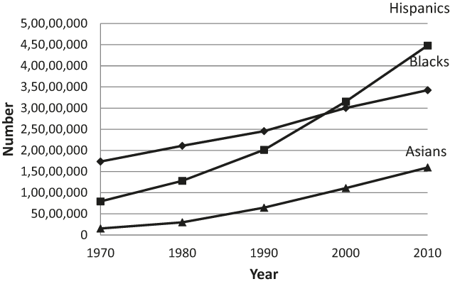
As noted above, group size strongly affects the potential for segregation and isolation experienced by minority members in metropolitan America, so we begin our analysis by showing trends in the number of Hispanics, Blacks, and Asians residing in our panel of 287 metropolitan statistical areas from 1970 through 2010. As seen in Figure 1, the greatest change in the nation’s racial-ethnic makeup over past four decades has been the remarkable growth of the Hispanic population, which surged from eight million to forty-five million persons and went from 4.7% to 16.3% of the population of these MSAs. The number of Asians also grew very rapidly, expanding by a factor of more than ten, but from a much smaller base, going from 1.5 million in 1970 to sixteen million in 2010 and raising their share of the population from 0.8% to 4.7%. Over the same period, the number African Americans roughly doubled in size, going from 17.4 to 34.2 million, but their share of the population climbed upward only slowly, going from 11.1% to 12.6% owing mainly to immigration from Africa and the Caribbean. In strictly demographic terms, then, we can say that the potential for segregation and isolation in metropolitan America increased sharply for Hispanics and to a lesser extent for Asians, but shifted little for African Americans.

Fig. 1. Growth of Minorities in U.S. Metropolitan Areas 1970–2010
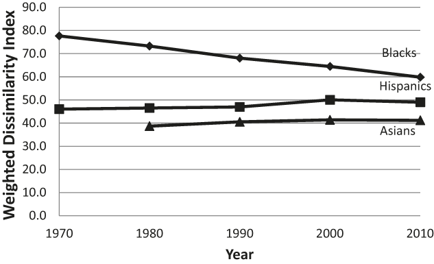
Figure 2 shows average values of residential dissimilarity with respect to non-Hispanic Whites for Blacks, Hispanics, and Asians in the 287 metropolitan areas from 1970 to 2010. The average values were computed by weighting the dissimilarity for each metropolitan area by the size of the minority population. Thus the average index for Blacks in 2010 gives the degree of neighborhood segregation experienced by the average Black inhabitant of the 287 metropolitan areas in that year. In considering tract-level residential dissimilarities, index values below 30 are conventionally considered “low;” those between 30 and 60 are viewed as “moderate;” those above 60 are seen as “high;” while any value above 75 is labeled “extreme” (Massey and Denton, Reference Massey and Denton1988a).

Fig. 2. Trends in Neighborhood-Level Dissimilarity from Whites 1970–2010
According to these standards, over the past four decades African American segregation has fallen from extreme to merely high levels. The pace of the decline was roughly linear, with the index dropping from an average value of 78 in 1970 to reach 60, the lower boundary of the high range, in 2010, a decline of about 4.5 index points per decade. The prevailing trend in Black-White segregation is thus one of moderate but steady decline. Nonetheless, at the current rate of change, average Black-White residential dissimilarity would not reach the upper threshold of the low range for another sixty-seven years.
In contrast to the pattern of steady decline observed for Blacks, the prevailing pattern of residential dissimilarity for Hispanics and Asians is one of relative stasis. Despite the massive increase in the size of both groups, dissimilarity indices for Hispanics and Asians rose only slightly over the past four decades. Average Hispanic-White dissimilarity rose from a value of 46 in 1970 to 49 in 2010 while average Asian-White dissimilarity only rose from 39 to 41 between 1980 and 2010. Such stability in residential dissimilarity in the face of rapid population growth is remarkable. Whereas in the twentieth century the growth of Black urban populations spurred Whites to practice more intense exclusion and discrimination that yielded sharply rising Black-White dissimilarities (Lieberson Reference Lieberson1980; Massey and Denton, Reference Massey and Denton1993; Sugrue Reference Sugrue1996), the rapid growth of metropolitan Hispanic and Asian populations from 1970 to 2010 does not appear to have triggered a comparable surge in Hispanic-White or Asian-White segregation. The contrasting experience of African Americans in the early twentieth century compared with that of Hispanics and Asians today implies that rising numbers of African Americans then posed a much greater threat to Whites than rising numbers of Hispanics and Asians do today.
When it comes to spatial isolation, both substantive and mathematical effects are relevant in determining index values because the P* index is a mathematical function of the minority percentage. It necessarily increases as the minority percentage rises no matter how Whites react to a growing minority presence or how dissimilarity changes. Indeed, even if residential dissimilarity were to remain constant, the isolation index would increase if the minority percentage were to rise. For African Americans, then, the trend in spatial isolation is expected to depend on which process has more force in determining index values: the slight increase in the demographic potential for isolation attributable to the slow increase in the Black percentage over the four decades or the faster decline in the structural potential for segregation brought about the slow but steady decrease in residential dissimilarity.
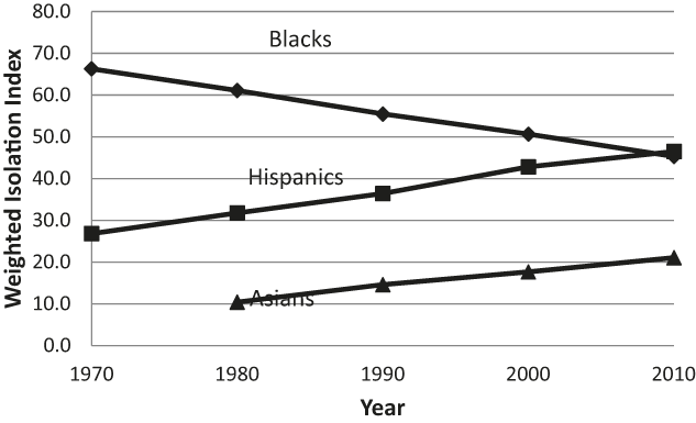
As Figure 3 shows, the effect of the steadily decline in Black dissimilarity appears to outweigh the modest increase in the relative size of the urban Black population in determining Black isolation. As before, we computed size-weighted isolation indices for Blacks, Hispanics, and Asians from 1970 through 2010. The degree of spatial isolation experienced by African Americans decreased linearly at roughly the same rate as the decline in dissimilarity, falling by an average of 4.8 points per decade and dropping from a value of 65 in 1970 to 46 in 2010. In contrast, Hispanic isolation increased quite sharply, as we would expect given the large increase in group size combined with slowly rising dissimilarity. The Hispanic isolation index rose from 27 to 47 over the period, an increase of around 5 points per decade. We also observe an increase in Asian spatial isolation, which went from an index value of 10 in 1980 to reach 21 in 2010. Given their small share of most metropolitan populations, however, the pace of the increase was only about 3.7 points per decade for Asians, and even the value of 21 in 2010 indicates a relatively low level of Asian spatial isolation.

Fig. 3. Trends in Neighborhood-Level Isolation Indices 1970–2010
In sum, Black dissimilarity and isolation indices have both steadily declined over the past four decades at a rate of around 5 points per decade and the average level of Black-White dissimilarity now lies at the frontier between “high” and “moderate” segregation with an index value of 60. In contrast, dissimilarity and isolation have both increased for Hispanics and Asians. Although the increase in dissimilarity has been slight and in 2010 both remained well within the “moderate” range of segregation, increases in the size of the Asian and Hispanic populations have pushed isolation indices upward. Although the rate of Asian growth has been sharp, the relative size of the population has remained small in most metropolitan areas and average isolation remains quite low with an index value of 20. Among Hispanics, however, rapid rates of urban population growth has combined with very large absolute numbers have increased spatial isolation to levels comparable to those of African Americans. As of 2010, the average isolation index stood at roughly 46 for both groups.
Despite the impressive shifts toward integration by African Americans overall, the declines have been quite uneven across metropolitan areas. In general, levels of segregation and isolation are much higher and the declines considerably slower among large metropolitan areas with large Black populations. Indeed, in their analysis of residential segregation in the fifty largest metropolitan areas of 1980, Massey and Denton (Reference Massey and Denton1989, Reference Massey and Denton1993) identified sixteen areas in which African Americans experienced a uniquely intense form of segregation across multiple geographic dimensions, a condition they labeled “hypersegregation.” Neither Hispanics nor Asians experienced hypersegregation in the metropolitan areas they examined. Wilkes and Iceland (Reference Wilkes and Iceland2004) updated the analysis using 2000 census data for all metropolitan areas and identified twenty-nine metropolitan areas in which African Americans were hypersegregated. Although Asians still did not experience hypersegregation in any metropolitan area, by 2000 hypersegregation for Hispanics had emerged in the Los Angeles and New York metropolitan areas.
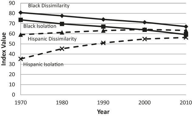
In Figure 4 we consider trends in residential segregation and spatial isolation for Hispanics and Blacks in those areas identified as hypersegregated in 2000. These metropolitan areas contain roughly a third of all African Americans in the United States and nearly half of those who live in metropolitan areas, and they account for 16% of all Latinos and close to 20% of metropolitan Latinos. Obviously in these metropolitan areas that house a disproportionate share of Blacks and Hispanics levels of segregation and isolation are considerably higher and downward trends are far more limited than among metropolitan areas in general. Among hypersegregated Black areas dissimilarity falls from 81 to 67 and isolation drops from 74 to 59 for a decline of only 3.5–3.7 points per year, leaving Black-White dissimilarity well within the high range in 2010 and isolation at a very elevated level. In the two hypersegregated Hispanic areas, moreover, levels of dissimilarity and isolation rose such that both came to roughly equal those observed in Black hypersegregated areas.

Fig. 4. Trends in Segregation and Isolation within Hypersegregated Metropolitan Areas
Finally, we consider what neighborhood circumstances look like from the viewpoint of non-Hispanic Whites. To this point our analyses of neighborhood composition have relied strictly on the P* isolation index, but P* actually refers to a family of isolation and contact indices. The isolation index gives the average likelihood of within-neighborhood contact with members of one’s own group whereas contact indices give the likelihood of within-neighborhood contact with members of other groups. Within any metropolitan area, the isolation and contact indices for any given group must sum up to 100. Figure 5 examines how the world has changed for Whites by presenting weighted averages computed to measure the degree of own-group isolation and intergroup contact for Whites residing in neighborhoods of the 287 metropolitan areas between 1970 and 2010.

Fig. 5. Trends in White Isolation and Contact Indices
These figures underscore the asymmetric nature residential experiences for minority and majority group members in metropolitan areas, for despite the steady declines in Black segregation, falling Black isolation, the massive increase of Hispanics, and the large increase of Asians within metropolitan areas, Whites still inhabit overwhelmingly White neighborhoods. Although the White isolation index dropped from a value of 91 in 1970 to 74 in 2010—some 4.4 points per decade—the starting point constituted a very extreme level of isolation. Moreover, despite the shift in White isolation, the average White American still lived in a neighborhood that was roughly three-quarters White in 2010, a time when the United States as a whole was only 63% White and that share was rapidly falling.
Mixing within neighborhoods likewise has not kept pace with the changing racial-ethnic composition of the nation for the shift away from White isolation involved relatively small changes in the degree of contact with minority group members. In the four decades from 1970 to 2010, for example, the likelihood of White neighborhood contact with African Americans rose by less than 1 point per decade to yield an index value of 8 in 2010; contact with Asians grew by just 1.4 point per decade to reach a value of 6 in 2010; and contact with Hispanics rose by only 2 points per decade to achieve a value of 11. It is only through the combined effect of rising contact with Hispanics, Blacks, and Asians together that White isolation fell to the extent observed. Considered on a group-by-group basis, contact probabilities with minority groups remain minuscule. In the end, the vast majority of Whites do not experience the rising racial-ethnic diversity of contemporary America.
EXPLAINING CONTEMPORARY SEGREGATION AND ISOLATION
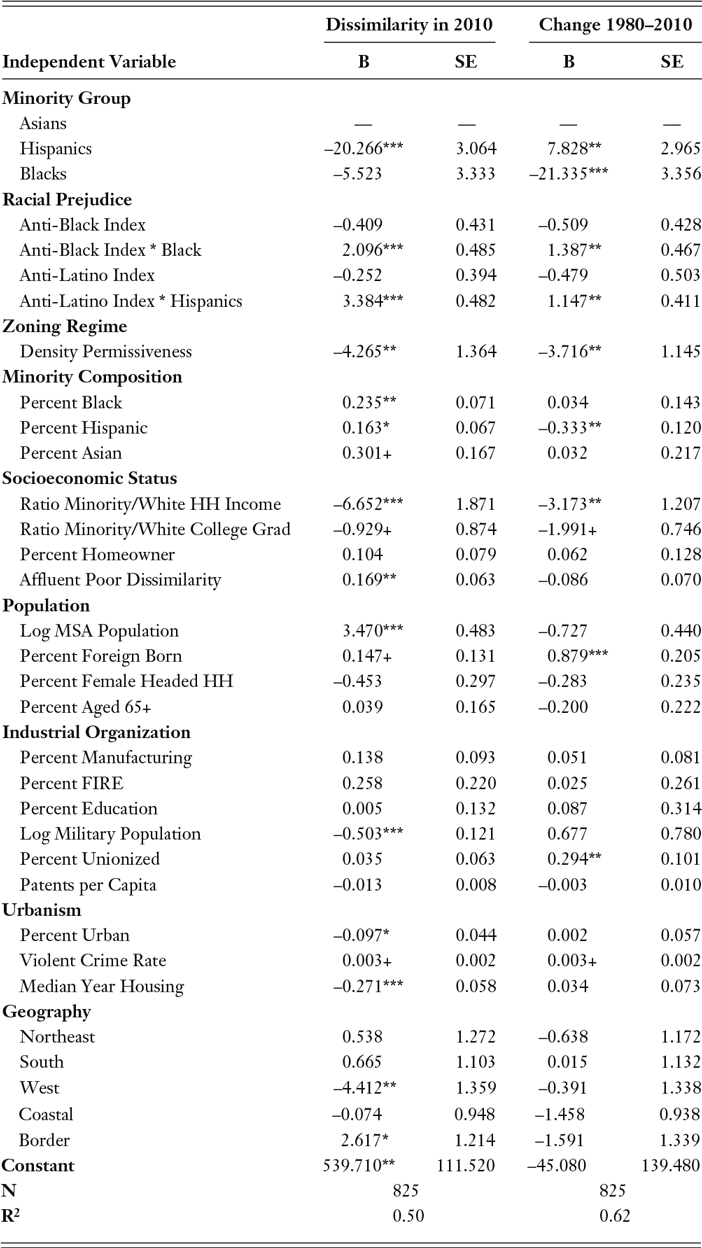
In order to isolate the principal drivers of segregation and integration we estimated the effect of the independent variables described in Table 1 on levels of residential dissimilarity and spatial isolation in 2010. We also assess the determinants of change from 1980 to 2010 by regressing changes in dissimilarity and isolation scores on changes in the values of the various independent variables over the period. Rather than estimating separate models for African Americans, Hispanics, and Asians, for economy of presentation we concatenate data for the three groups into a single file and include dummy variables to indicate which group’s segregation is being measured as the dependent variable. All independent variables pertain to the metropolitan area population as a whole except for the indices of racism and illegal immigration, which are specific to Blacks and Hispanics, respectively, and the ratios of minority/White income and minority/White college graduates which are defined with respect to Blacks, Hispanics, and Asians when regressed on dissimilarities defined for the same three groups.
As of 2010, the group dummy variables in the first panel indicate that if other factors in the model were equal, Hispanics would exhibit a residential dissimilarity from Whites that was 20.3 points below that of Asians (p < 0.001) whereas African Americans would display a dissimilarity 5.5 points lower (n.s.). In fact, Asians are far less segregated from Whites than either Blacks or Hispanics, which implies that other things are decidedly not equal. In the second panel of Table 2 we interact these indices of anti-Black and anti-Latino sentiment with the dummy variables for membership in each group. Results indicate that anti-Black racism has a powerful and highly significant effect in predicting the level of Black-White segregation. Each point increase in the anti-Black index raises the expected level of Black-White dissimilarity by 2.09 points, potentially raising the dissimilarity index by 15 points over the observed range of the scale. Among Latinos, the effect is even more pronounced. Each point increase in the anti-Latino index raises Hispanic-White dissimilarity by 3.4 points, potentially raising Hispanic dissimilarity by 23 points over the observed range of the index.
Table 2. Effect of Selected Variables on Minority-White Residential Dissimilarity in 2010 and 1980–2010 Change

*** p < .001 **p < .01 *p < .05 + p < .10 (Note: Number of MSAs = 275)
As expected, the density instrument also strongly predicts the degree of racial-ethnic segregation across metropolitan areas. In this case, a higher density score indicates a more permissive zoning regime, allowing a higher average level of residential density. As can be seen, higher allowable densities are associated with significantly lower levels of residential dissimilarity. Moving the index from its observed minimum to its observed maxim would reduce residential dissimilarity by 16 points.
Also as expected, residential dissimilarity is predicted by the relative size of the minority population. Each point increase in the percentage of Blacks raises dissimilarity by 0.235 points, yielding a potential increase of 12 points as the percentage goes from its observed minimum to maximum. Likewise, each point increase in the percentage of Hispanics raises dissimilarity by 0.163 points, yielding a potential shift of 15 points from its minimum to maximum. Although the coefficient is only marginally significant (p < 0.10), each point increase in the percentage of Asians raises dissimilarity by 0.301 points, yielding a potential shift of 21 points over the observed range of percentages.
Aside from their relative numbers, the relative income of each minority group strongly predicts the residential dissimilarity they experience. Each point increase in the ratio of minority to White household income lowers residential dissimilarity by 6.65 points. Among African Americans the income ratio varies from 0.17 to 1.14, yielding a potential drop in dissimilarity of 6.5 points over the range of the index. Among Hispanics the range is from 0.31 to 1.43, yielding a potential drop of 7.5 points; but among Asians the range goes from 0.35 to 2.81 yielding a potential decline of 16.4 points. Thus, one important reason for the lower level of Asian-White dissimilarity is the relatively high incomes earned by Asians, which in most metropolitan areas top those of Whites. The ratio of college-educated minority members to college educated Whites works in the same direction—lowering levels of residential dissimilarity—but the effect is much weaker and only marginally significant. Racial-ethnic segregation, however, is quite strongly and positively associated with the degree of class segregation. The residential dissimilarity between the affluent and the poor is potentially responsible for an upward shift of 6 points in the level of racial-ethnic dissimilarity as it goes from its observed minimum to maximum.
As other researchers have found, we also find that racial-ethnic segregation is greater in large metropolitan areas and lower in areas with a sizeable military presence and in those with a newer housing stock. Each point increase in the log of metropolitan population increases residential dissimilarity by 3.47 points potentially accounting for a shift of 17 points from the smallest to the largest metropolitan area. However, each point increase in the log of the military population per 100,000 persons reduces racial-ethnic dissimilarity by 0.503 points whereas each year increase in the median year of housing lowers it by 0.271 points, yielding potential reductions of 4 points and 12 points, respectively, as these variables range from minimum to maximum. A few of our other substantive predictors—percent foreign born, percent urban, and the violent crime rate—also predict racial-ethnic segregation but the effects are weak and usually only of marginal significance. Among geographic effects, we see that levels or racial and ethnic segregation are systematically lower in the West (by 4.412 points) compared with the Midwest and systematically higher in border states (by 2.617 points) than elsewhere in the country.
The right-hand columns show a model predicting change in racial-ethnic dissimilarity between 1980 and 2010. The dummy variables indicating group membership, the prejudice indices, the density instrument, and the geographic indicators are all time-invariant but all other variables are defined in terms of their change between 1980 and 2010. As we would expect given trends already reported, the coefficient for Hispanics is positive and significant (7.828), the coefficient for Blacks is negative and significant, (-21.335) indicating that, other things equal, Hispanic segregation increased over the three decades while Black segregation decreased. In both cases, however, shifts toward integration were impeded by higher levels of anti-Black or anti-Latino sentiment, and across metropolitan areas by more restrictive regimes of density zoning. Holding constant anti-Latino sentiment, however, an increase in the percentage Hispanic was associated with a lower level of residential dissimilarity. Rising minority income relative to Whites was strongly associated with declining residential dissimilarity, as was rising education relative to Whites, though as in the cross-sectional model the latter effect was much weaker an only marginally significant. Not surprisingly, immigration, as measured by a rising share of foreign born, was strongly associated with rising residential dissimilarity as was the metropolitan rate of unionization.
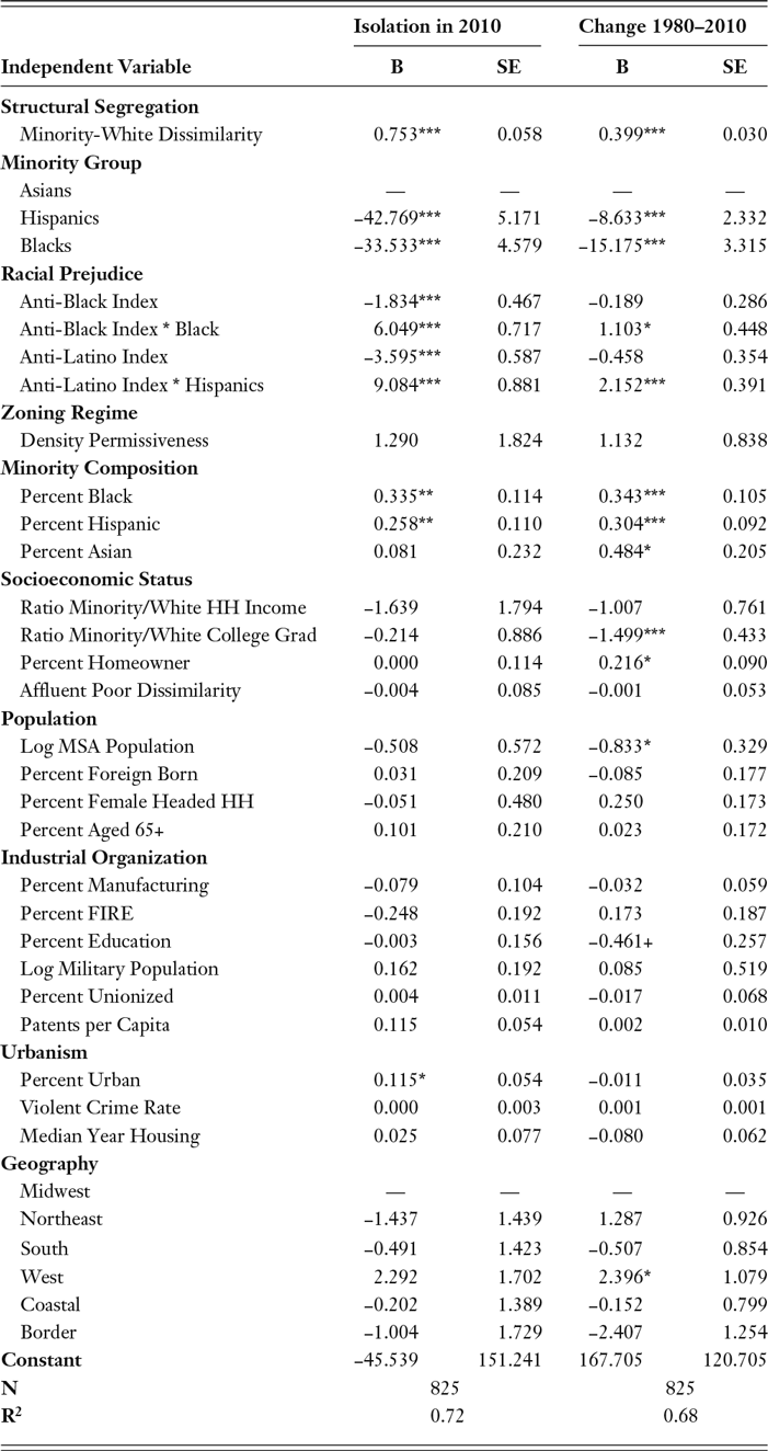
Table 3 presents regressions to predict the degree of spatial isolation in 2010 as well as changes in isolation between 1980 and 2010, conditional on the observed level of residential dissimilarity. The degree of spatial isolation experienced by a group largely follows from its relative size and the degree of residential dissimilarity it experiences. It is no surprise, therefore to discover that residential dissimilarity and minority percentages very powerfully predict the level of isolation in 2010 as well as changes from 1980 to 2010. These findings are not substantively interesting since they follow directly from the definition and properties of the P* index. What is of interest here is the other factors that contribute to spatial isolation above and beyond these mathematical determinants.
Table 3. Effect of Selected Variables on Spatial Isolation in 2010 and 1980–2010 Change

*** p < .001 **p < .01 *p < .05 + p < .10 (Note: Number of MSAs = 275)
As can be seen, the principal determinant of spatial isolation beyond dissimilarity and minority composition is the extent of racial prejudice, which acts to intensify isolation in the cross section and forestall reductions over time. Each point increase in anti-Black sentiment increases the spatial isolation of African Americans by 6.049 points and is associated with an increase of 1.103 points in isolation over time, yielding potential shifts of 42 points in the degree of isolation and 8 points of change in isolation over the observed range of anti-Black prejudice. Likewise, each point increase in anti-Latino sentiment is associated with an increase of 9.084 points in the degree of Hispanic spatial isolation and a 2.152 point increase in isolation over time, yielding potential shifts of 61 points of isolation and 14 points of change in isolation over the observed range of the prejudice index. Beyond these effects, not much else affects the level of spatial isolation. The only strong effect is the effect of a higher relative level of minority education, which promotes a decline in racial-ethnic isolation over time. The zoning instrument has no effect, implying that its influence on spatial isolation occurs entirely through its strong effect on residential dissimilarity.
CONCLUSION
The foregoing analyses reveal that the United States is neither moving toward the end of the segregated century nor resting at a point of stalled integration. Rather, Black and Hispanic segregation and spatial isolation continue to be actively produced in some metropolitan areas while being mitigated in others. On the one hand, segregated metropolitan areas are those of large size with relatively large but poor minority populations, an older stock of housing, a restrictive regime of density zoning, little military presence, and rapid immigration. In addition to these structural metropolitan circumstances, segregation and isolation are boosted by a high degree of anti-Black or anti-Latino sentiment. According to our analyses, those metropolitan areas that are integrating over time are those having relatively affluent and well-educated minority populations, low levels of anti-Black and anti-Latino sentiment, low rates of immigration, and permissive regimes of density zoning.
These forces yield a varied panorama of trends, with segregation and isolation falling sharply in some areas but persisting at high levels in others. Although Asians generally experience very moderate levels of segregation and little isolation wherever they live, Blacks continue to experience high segregation and little progress toward integration in many metropolitan areas while Hispanics display rising levels of segregation and isolation in other areas. In both cases, metropolitan areas displaying high segregation and little progress toward integration house a disproportionate number of minority group members. As a result, hypersegregation continues to characterize the residential experience of a large share of both African Americans and Hispanics even as some areas move rapidly toward integration.
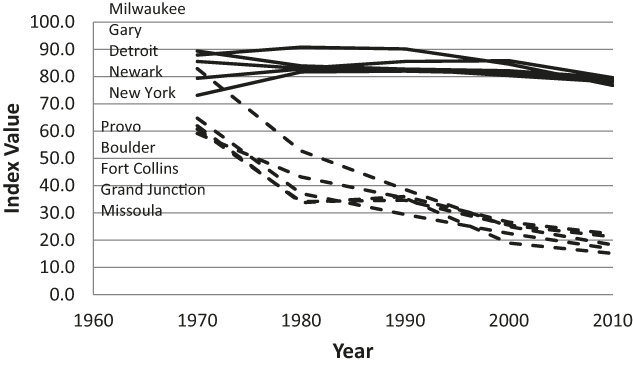
The contrast is well illustrated by the two extremes of the distribution of metropolitan areas by residential dissimilarity. Figure 6 shows trends in Black-White dissimilarity for the five most and five least racially segregated metropolitan areas in 2010. As can be seen, Black segregation fell sharply in Provo, UT, Missoula, MT, as well as in Boulder, Fort Collins, and Grand Junction, CO—all small metropolitan areas in western states with small, relatively affluent Black populations characterized by low levels of prejudice and a relative absence of restrictive density zoning regulations. In addition, Provo, Fort Collins, Missoula, and Boulder also happen to be college towns, which Farley and Frey (Reference Farley and Frey1994) found generally display lower levels of racial segregation.

Fig. 6. Trends in Black-White Dissimilarity in Five Most and Five Least Segregated Metropolitan Areas
In contrast, Black segregation persisted virtually unchanged at extremely high levels in Milwaukee, WI, Gary, IN, Detroit, MI and New York—large metropolitan areas with sizeable, poor Black communities in areas characterized by a relatively high level of anti-Black prejudice and restrictive density zoning regimes. Thus, in the five most segregated areas, the average Black percentage was high at 23.8%, the average zoning score was relatively restrictive at 2.97, and the average index of anti-Black sentiment stood at 68.8. In contrast, across the five least segregated areas the average Black percentage stood at just 1.0%, the average density score was almost a point more permissive at 3.82, and the average index of anti-Black sentiment was more than ten points lower at 54.6.
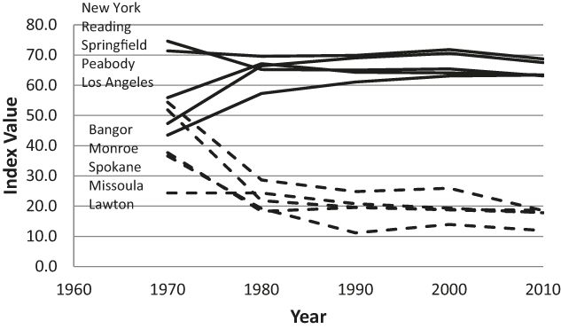
Figure 7 shows comparable trends for Hispanic-White dissimilarity in the five most and least segregated areas for Hispanics in 2010. Sharp declines in segregation are observed in Bangor, ME, Monroe, MI, Spokane, WA, Missoula, MT, and Lawton, OK—generally small metropolitan areas with relatively small, slowly growing Hispanic populations characterized by low levels of immigration, little anti-Latino sentiment, and permissive density zoning regimes. At the same time, increases in segregation were observed in the two largest areas of Hispanic settlement, New York and Los Angeles (which became hypersegregated during the period). In addition, three smaller metropolitan areas experienced rapid immigration and Hispanic population growth in areas characterized by restrictive zoning regimes and notable anti-immigrant sentiment—Springfield and Peabody, MA and Reading, PA.

Fig. 7. Trends in Hispanic-White Dissimilarity in Five Most and Five Least Segregated Metropolitan Areas
The latter areas also have historically housed predominantly Puerto Rican populations, which have long experienced greater segregation levels than other Hispanic groups owing to their Afro-Caribbean heritage (Denton and Massey, Reference Denton and Massey1989; Massey and Bitterman, Reference Massey and Bitterman1985). Nonetheless, all three metropolitan areas experienced rapid Hispanic population growth driven largely by immigration from other Latin American nations, which in two cases dramatically reduced the relative share of Puerto Ricans. By 2010 only 28% of Hispanics in Peabody were Puerto Rican and just 56% were Puerto Rican in Reading (the figure remained high at 85% in Springfield). In any event, the five most segregated metropolitan areas for Hispanics exhibited an average Hispanic percentage of 24.7% and a change of 13.9 points since 1980, compared with figures of just 4.5% and 1.7 in the five least segregated areas. Likewise, the density index was less permissive at 3.12 compared with 3.58 in the least segregated areas and anti-Latino sentiment was greater at 60 compared with 50.
In sum, the situation with respect to residential segregation and spatial isolation has become substantially more varied across metropolitan America since 1980. For African Americans, the ghetto has shifted from being a universal feature of urban life to being a variable condition associated with metropolitan characteristics such as large population size, a high Black percentage, and elevated levels of racial prejudice. For Latinos, the barrio has become an increasingly common feature of urban life in those metropolitan areas where the percentage of Hispanics is high, the population has been growing because of rapid immigration, and anti-Latino sentiment is high. Across all metropolitan areas, restrictive density zoning has emerged as a strong force producing segregation and isolation for both groups and shifts toward integration are associated with higher minority socioeconomic status. Which trend prevails in the long run—continued segregation or moves toward integration—remains to be seen; but residential segregation clearly is not yet a thing of the past in the United States.
Appendix A Metropolitan areas included in balanced panel.
Abilene, TX MSA
Akron, OH MSA
Albany, GA MSA
Albany-Schenectady-Troy, NY MSA
Albuquerque, NM MSA
Alexandria, LA MSA
Allentown-Bethlehem-Easton, PA-NJ MSA
Altoona, PA MSA
Amarillo, TX MSA
Ames, IA MSA
Anchorage, AK MSA
Anderson, IN MSA
Anderson, SC MSA
Ann Arbor, MI MSA
Anniston-Oxford, AL MSA
Appleton, WI MSA
Asheville, NC MSA
Athens-Clarke County, GA MSA
Atlanta-Sandy Springs-Marietta, GA MSA
Atlantic City-Hammonton, NJ MSA
Auburn-Opelika, AL MSA
Augusta-Richmond County, GA-SC MSA
Austin-Round Rock-San Marcos, TX MSA
Bakersfield-Delano, CA MSA
Baltimore-Towson, MD MSA
Bangor, ME MSA
Barnstable Town, MA MSA
Baton Rouge, LA MSA
Battle Creek, MI MSA
Bay City, MI MSA
Beaumont-Port Arthur, TX MSA
Bellingham, WA MSA
Bend, OR MSA
Bethesda-Rockville-Frederick, MD MDIV
Billings, MT MSA
Binghamton, NY MSA
Birmingham-Hoover, AL MSA
Bismarck, ND MSA
Blacksburg-Christiansburg-Radford, VA MSA
Bloomington, IN MSA
Bloomington-Normal, IL MSA
Boise City-Nampa, ID MSA
Boston-Quincy, MA MDIV
Boulder, CO MSA
Bowling Green, KY MSA
Bremerton-Silverdale, WA MSA
Bridgeport-Stamford-Norwalk, CT MSA
Brownsville-Harlingen, TX MSA
Brunswick, GA MSA
Buffalo-Niagara Falls, NY MSA
Burlington, NC MSA
Burlington-South Burlington, VT MSA
Cambridge-Newton-Framingham, MA MDIV
Camden, NJ MDIV
Canton-Massillon, OH MSA
Cape Coral-Fort Myers, FL MSA
Cape Girardeau-Jackson, MO-IL MSA
Carson City, NV MSA
Casper, WY MSA
Cedar Rapids, IA MSA
Champaign-Urbana, IL MSA
Charleston, WV MSA
Charleston-North Charleston-Summerville, SC MSA
Charlotte-Gastonia-Rock Hill, NC-SC MSA
Charlottesville, VA MSA
Chattanooga, TN-GA MSA
Cheyenne, WY MSA
Chicago-Joliet-Naperville, IL MDIV
Chico, CA MSA
Cincinnati-Middletown, OH-KY-IN MSA
Clarksville, TN-KY MSA
Cleveland, TN MSA
Cleveland-Elyria-Mentor, OH MSA
Coeur d’Alene, ID MSA
College Station-Bryan, TX MSA
Colorado Springs, CO MSA
Columbia, MO MSA
Columbia, SC MSA
Columbus, GA-AL MSA
Columbus, IN MSA
Columbus, OH MSA
Corpus Christi, TX MSA
Corvallis, OR MSA
Crestview-Fort Walton Beach-Destin, FL MSA
Cumberland, MD-WV MSA
Dallas-Plano-Irving, TX MDIV
Dalton, GA MSA
Danville, IL MSA
Danville, VA MSA
Davenport-Moline-Rock Island, IA-IL MSA
Dayton, OH MSA
Decatur, AL MSA
Decatur, IL MSA
Deltona-Daytona Beach-Ormond Beach, FL MSA
Denver-Aurora-Broomfield, CO MSA
Des Moines-West Des Moines, IA MSA
Detroit-Livonia-Dearborn, MI MDIV
Dothan, AL MSA
Dover, DE MSA
Dubuque, IA MSA
Duluth, MN-WI MSA
Durham-Chapel Hill, NC MSA
Eau Claire, WI MSA
Edison-New Brunswick, NJ MDIV
El Centro, CA MSA
Elizabethtown, KY MSA
Elkhart-Goshen, IN MSA
Elmira, NY MSA
El Paso, TX MSA
Erie, PA MSA
Eugene-Springfield, OR MSA
Evansville, IN-KY MSA
Fairbanks, AK MSA
Fargo, ND-MN MSA
Farmington, NM MSA
Fayetteville, NC MSA
Fayetteville-Springdale-Rogers, AR-MO MSA
Flagstaff, AZ MSA
Flint, MI MSA
Florence, SC MSA
Florence-Muscle Shoals, AL MSA
Fond du Lac, WI MSA
Fort Collins-Loveland, CO MSA
Fort Lauderdale-Pompano Beach-Deerfield Beach, FL MDIV
Fort Smith, AR-OK MSA
Fort Wayne, IN MSA
Fort Worth-Arlington, TX MDIV
Fresno, CA MSA
Gadsden, AL MSA
Gainesville, FL MSA
Gainesville, GA MSA
Gary, IN MDIV
Glens Falls, NY MSA
Goldsboro, NC MSA
Grand Forks, ND-MN MSA
Grand Junction, CO MSA
Grand Rapids-Wyoming, MI MSA
Great Falls, MT MSA
Greeley, CO MSA
Green Bay, WI MSA
Greensboro-High Point, NC MSA
Greenville, NC MSA
Greenville-Mauldin-Easley, SC MSA
Gulfport-Biloxi, MS MSA
Hagerstown-Martinsburg, MD-WV MSA
Hanford-Corcoran, CA MSA
Harrisburg-Carlisle, PA MSA
Harrisonburg, VA MSA
Hartford-West Hartford-East Hartford, CT MSA
Hattiesburg, MS MSA
Hickory-Lenoir-Morganton, NC MSA
Hinesville-Fort Stewart, GA MSA
Holland-Grand Haven, MI MSA
Honolulu, HI MSA
Hot Springs, AR MSA
Houma-Bayou Cane-Thibodaux, LA MSA
Houston-Sugar Land-Baytown, TX MSA
Huntington-Ashland, WV-KY-OH MSA
Huntsville, AL MSA
Idaho Falls, ID MSA
Indianapolis-Carmel, IN MSA
Iowa City, IA MSA
Ithaca, NY MSA
Jackson, MI MSA
Jackson, MS MSA
Jackson, TN MSA
Jacksonville, FL MSA
Jacksonville, NC MSA
Janesville, WI MSA
Jefferson City, MO MSA
Johnson City, TN MSA
Johnstown, PA MSA
Jonesboro, AR MSA
Joplin, MO MSA
Kalamazoo-Portage, MI MSA
Kankakee-Bradley, IL MSA
Kansas City, MO-KS MSA
Kennewick-Pasco-Richland, WA MSA
Killeen-Temple-Fort Hood, TX MSA
Kingsport-Bristol-Bristol, TN-VA MSA
Kingston, NY MSA
Knoxville, TN MSA
Kokomo, IN MSA
La Crosse, WI-MN MSA
Lafayette, IN MSA
Lafayette, LA MSA
Lake Charles, LA MSA
Lake County-Kenosha County, IL-WI MDIV
Lake Havasu City-Kingman, AZ MSA
Lakeland-Winter Haven, FL MSA
Lancaster, PA MSA
Lansing-East Lansing, MI MSA
Laredo, TX MSA
Las Cruces, NM MSA
Las Vegas-Paradise, NV MSA
Lawrence, KS MSA
Lawton, OK MSA
Lebanon, PA MSA
Lewiston, ID-WA MSA
Lewiston-Auburn, ME MSA
Lexington-Fayette, KY MSA
Lima, OH MSA
Lincoln, NE MSA
Little Rock-North Little Rock-Conway, AR MSA
Logan, UT-ID MSA
Longview, TX MSA
Longview, WA MSA
Los Angeles-Long Beach-Glendale, CA MDIV
Louisville/Jefferson County, KY-IN MSA
Lubbock, TX MSA
Lynchburg, VA MSA
Macon, GA MSA
Madera-Chowchilla, CA MSA
Madison, WI MSA
Manchester-Nashua, NH MSA
Manhattan, KS MSA
Mankato-North Mankato, MN MSA
Mansfield, OH MSA
McAllen-Edinburg-Mission, TX MSA
Medford, OR MSA
Memphis, TN-MS-AR MSA
Merced, CA MSA
Miami-Miami Beach-Kendall, FL MDIV
Michigan City-La Porte, IN MSA
Midland, TX MSA
Milwaukee-Waukesha-West Allis, WI MSA
Minneapolis-St. Paul-Bloomington, MN-WI MSA
Missoula, MT MSA
Mobile, AL MSA
Modesto, CA MSA
Monroe, LA MSA
Monroe, MI MSA
Montgomery, AL MSA
Morgantown, WV MSA
Morristown, TN MSA
Mount Vernon-Anacortes, WA MSA
Muncie, IN MSA
Muskegon-Norton Shores, MI MSA
Myrtle Beach-North Myrtle Beach-Conway, SC MSA
Napa, CA MSA
Naples-Marco Island, FL MSA
Nashville-Davidson-Murfreesboro-Franklin, TN MSA
Nassau-Suffolk, NY MDIV
Newark-Union, NJ-PA MDIV
New Haven-Milford, CT MSA
New Orleans-Metairie-Kenner, LA MSA
New York-White Plains-Wayne, NY-NJ MDIV
Niles-Benton Harbor, MI MSA
North Port-Bradenton-Sarasota, FL MSA
Norwich-New London, CT MSA
Oakland-Fremont-Hayward, CA MDIV
Ocala, FL MSA
Ocean City, NJ MSA
Odessa, TX MSA
Ogden-Clearfield, UT MSA
Oklahoma City, OK MSA
Olympia, WA MSA
Omaha-Council Bluffs, NE-IA MSA
Orlando-Kissimmee-Sanford, FL MSA
Oshkosh-Neenah, WI MSA
Owensboro, KY MSA
Oxnard-Thousand Oaks-Ventura, CA MSA
Palm Bay-Melbourne-Titusville, FL MSA
Palm Coast, FL MSA
Panama City-Lynn Haven-Panama City Beach, FL MSA
Parkersburg-Marietta-Vienna, WV-OH MSA
Pascagoula, MS MSA
Peabody, MA MDIV
Pensacola-Ferry Pass-Brent, FL MSA
Peoria, IL MSA
Philadelphia, PA MDIV
Phoenix-Mesa-Glendale, AZ MSA
Pine Bluff, AR MSA
Pittsburgh, PA MSA
Pittsfield, MA MSA
Pocatello, ID MSA
Portland-South Portland-Biddeford, ME MSA
Portland-Vancouver-Hillsboro, OR-WA MSA
Port St. Lucie, FL MSA
Poughkeepsie-Newburgh-Middletown, NY MSA
Prescott, AZ MSA
Providence-New Bedford-Fall River, RI-MA MSA
Provo-Orem, UT MSA
Pueblo, CO MSA
Punta Gorda, FL MSA
Racine, WI MSA
Raleigh-Cary, NC MSA
Rapid City, SD MSA
Reading, PA MSA
Redding, CA MSA
Reno-Sparks, NV MSA
Richmond, VA MSA
Riverside-San Bernardino-Ontario, CA MSA
Roanoke, VA MSA
Rochester, MN MSA
Rochester, NY MSA
Rockford, IL MSA
Rockingham County-Strafford County, NH MDIV
Rocky Mount, NC MSA
Rome, GA MSA
Sacramento-Arden-Arcade-Roseville, CA MSA
Saginaw-Saginaw Township North, MI MSA
St. Cloud, MN MSA
St. George, UT MSA
St. Joseph, MO-KS MSA
St. Louis, MO-IL MSA
Salem, OR MSA
Salinas, CA MSA
Salisbury, MD MSA
Salt Lake City, UT MSA
San Angelo, TX MSA
San Antonio-New Braunfels, TX MSA
San Diego-Carlsbad-San Marcos, CA MSA
Sandusky, OH MSA
San Francisco-San Mateo-Redwood City, CA MDIV
San Jose-Sunnyvale-Santa Clara, CA MSA
San Luis Obispo-Paso Robles, CA MSA
Santa Ana-Anaheim-Irvine, CA MDIV
Santa Barbara-Santa Maria-Goleta, CA MSA
Santa Cruz-Watsonville, CA MSA
Santa Fe, NM MSA
Santa Rosa-Petaluma, CA MSA
Savannah, GA MSA
Scranton–Wilkes-Barre, PA MSA
Seattle-Bellevue-Everett, WA MDIV
Sebastian-Vero Beach, FL MSA
Sheboygan, WI MSA
Sherman-Denison, TX MSA
Shreveport-Bossier City, LA MSA
Sioux City, IA-NE-SD MSA
Sioux Falls, SD MSA
South Bend-Mishawaka, IN-MI MSA
Spartanburg, SC MSA
Spokane, WA MSA
Springfield, IL MSA
Springfield, MA MSA
Springfield, MO MSA
Springfield, OH MSA
State College, PA MSA
Steubenville-Weirton, OH-WV MSA
Stockton, CA MSA
Sumter, SC MSA
Syracuse, NY MSA
Tacoma, WA MDIV
Tallahassee, FL MSA
Tampa-St. Petersburg-Clearwater, FL MSA
Terre Haute, IN MSA
Texarkana, TX-Texarkana, AR MSA
Toledo, OH MSA
Topeka, KS MSA
Trenton-Ewing, NJ MSA
Tucson, AZ MSA
Tulsa, OK MSA
Tuscaloosa, AL MSA
Tyler, TX MSA
Utica-Rome, NY MSA
Valdosta, GA MSA
Vallejo-Fairfield, CA MSA
Victoria, TX MSA
Vineland-Millville-Bridgeton, NJ MSA
Virginia Beach-Norfolk-Newport News, VA-NC MSA
Visalia-Porterville, CA MSA
Waco, TX MSA
Warner Robins, GA MSA
Warren-Troy-Farmington Hills, MI MDIV
Washington-Arlington-Alexandria, DC-VA-MD-WV MDIV
Waterloo-Cedar Falls, IA MSA
Wausau, WI MSA
Wenatchee-East Wenatchee, WA MSA
West Palm Beach-Boca Raton-Boynton Beach, FL MDIV
Wheeling, WV-OH MSA
Wichita, KS MSA
Wichita Falls, TX MSA
Williamsport, PA MSA
Wilmington, DE-MD-NJ MDIV
Wilmington, NC MSA
Winchester, VA-WV MSA
Winston-Salem, NC MSA
Worcester, MA MSA
Yakima, WA MSA
York-Hanover, PA MSA
Youngstown-Warren-Boardman, OH-PA MSA
Yuba City, CA MSA
Yuma, AZ MSA

